Prosper in a dynamic world
Search

Heavy rain looms for eastern NSW

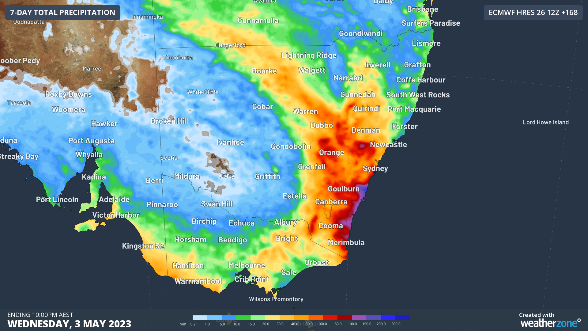
Widespread rain and thunderstorms will affect eastern Australia this weekend and early next week, with parts of eastern NSW expected to see more than 100 mm of rain by Monday.

A series of cold fronts and low pressure troughs will cause showers over a broad area of southern and eastern Australia during the remainder of this week.

This wet weather will initially be confined to parts of southern WA, SA, Vic and Tas on Thursday, with most areas only seeing light falls.

Showers and storms will spread further north into NSW from Friday and southern Qld from Saturday, as an upper-level trough pushes north and interacts with a feed of tropical moisture.

Forecast models suggest that rain will become more widespread and heavier over NSW and parts of southern Qld on the weekend as the upper-level trough transitions into a cut-off low above eastern Australia.

At this stage, the heaviest rain is likely to occur in NSW between Saturday and Monday. One area of particular risk for heavy rain and flooding will be the southern half of the NSW coast and adjacent ranges, where a focused stream of onshore winds could produce more than 100 mm of rain and possibly more than 200 mm in some places.

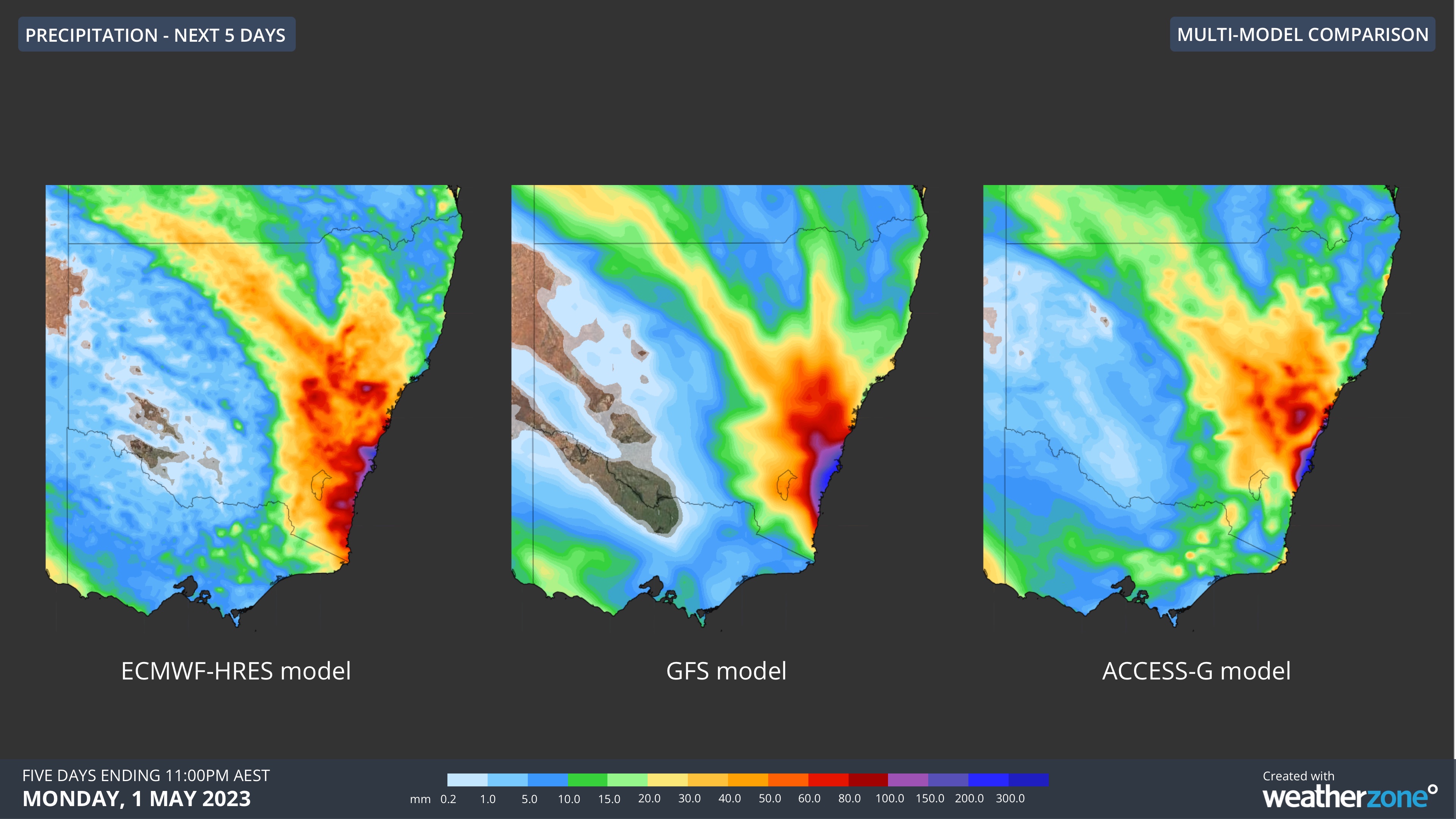
Image: Comparison of accumulated rain between Thursday, April 27 and Monday, May 1 from three different forecast models.

Severe weather warnings, flood watches and flood warnings may be issued for parts of eastern NSW this weekend as we start to get a clearer picture of where and how much rain will fall. Be sure to keep an eye on the latest warnings for the most up-to-date information on this evolving weather system.

DTN APAC provides a suite of services tailored towards the insurance industry. From severe weather ‘heads-up’ from our meteorologist team, to detailed warnings and extreme observation alerts, to post-event reporting, we can cover any major weather event. To find out more, please explore our website or email us at apac.sales@dtn.com.

Latest news

Satisfy your weather obsession with these news headlines from around the nation, and the world.

La Niña more likely this year after BoM switches to new index – what does this mean for Australian businesses?

The likelihood of La Niña occurring in 2025 has increased due to a change in the way the Bureau of Meteorology calculates sea surface temperature anomalies in the tropical Pacific Ocean. What is La Niña? La Niña refers to a distinct pattern of sea surface temperatures across the tropical Pacific Ocean. When La Niña is […]

Southern Hemisphere’s polar vortex is weakening – here’s what this means for Australian weather

Stratospheric warming high above Antarctica could cause the Southern Hemisphere’s polar vortex to weaken at an unusually fast pace over the coming weeks. This weakened polar vortex has the potential to affect weather patterns across Australia and other parts of the Southern Hemisphere. What is the polar vortex? The polar vortex is a large circulating […]

Severe thunderstorms, tornadoes and flooding rainfall lash out over NSW businesses and industries

Severe thunderstorms, tornadoes and flooding rainfall have disrupted transport, rail, aviation and many other industries across NSW as a low pressure system tracked over the state. Severe thunderstorms and tornadoes in western NSW A tornado was observed near the town of Young on the South West Slopes of New South Wales around 3:30pm on Wednesday […]

Wild night of rain, wind and surf coming for Sydney and surrounds disrupting port, transport and energy utility industries

Intense and disruptive thunderstorms, rain, strong winds and large surf will develop along eastern NSW later today, bringing localised areas of flooding and hazardous driving conditions. A cut-off low currently tracking over western NSW, is bringing heavy rain and thunderstorms to the region. This burst of early spring storms already marks the wettest September day […]