
Flood watches have been issued between central Queensland and northeast New South Wales as unseasonably heavy rain continues to drench parts of eastern Australia.
A deep layer of moisture-laden east-northeasterly winds interacting with a pair of upper-level low pressure systems is causing widespread rain over eastern Australia. This drenching kicked off on the weekend and will continue during the first half of this week.
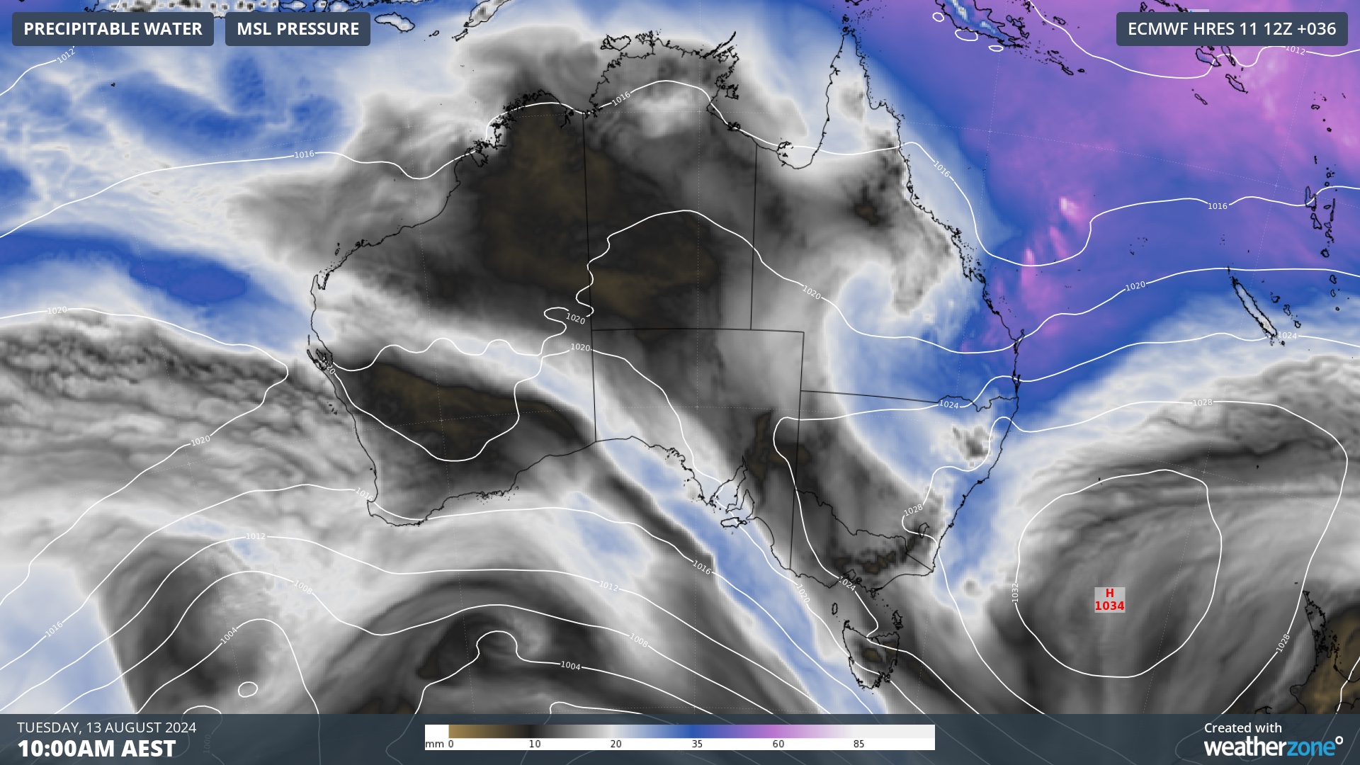
Image: Modelled precipitable water and mean sea level pressure on Tuesday morning, showing moisture-laden air being driven over eastern Australia.
Parts of eastern Qld and northeast NSW received more than 100 mm of rain during the 24 hours to 9am on Monday, including:
- 164 mm at Goonengerry, NSW
- 157 mm at Repentance, NSW
- 157 mm at Evans Head, NSW
- 138 mm at Upper Major Creek, Qld
- 116 mm at Ballina Airport, NSW
- 107 mm at Woodlands, Qld
- 103 mm at Haughton Bridge, Qld
For some places, this was the heaviest August rain in decades.
In Qld, Ayr’s 67.8 mm during the 24 hours to 9am on Monday was its heaviest August daily rainfall in 53 years. Townsville Airport’s 67.2 mm was also a 26-year high for an August day.
NSW also had a few places that picked up their best August rain of this century. Evans Head’s 157.4 mm was the site’s highest August daily total since records commenced there in 1998.
Rain will continue to soak a broad area of eastern Australia between Monday and Wednesday under the influence of the twin upper-level lows.
The maps below show how much rain two computer models are predicting over this three-day period, with the heaviest falls expected to occur in central Qld and northeast NSW.
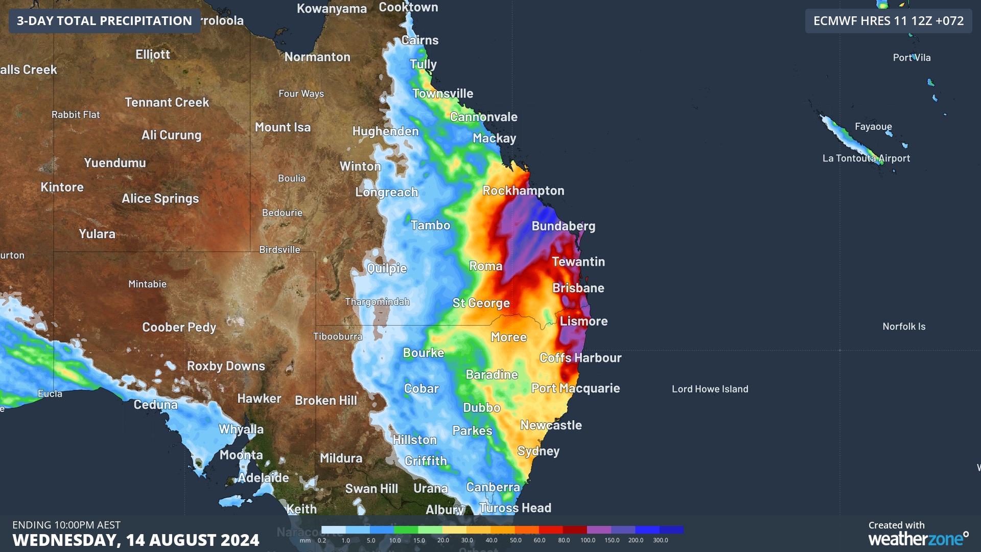
Image: Forecast accumulated rain during the 72 hours ending at 10pm AEST on Wednesday, August 14, 2024, according to the ECMWF-HRES model.
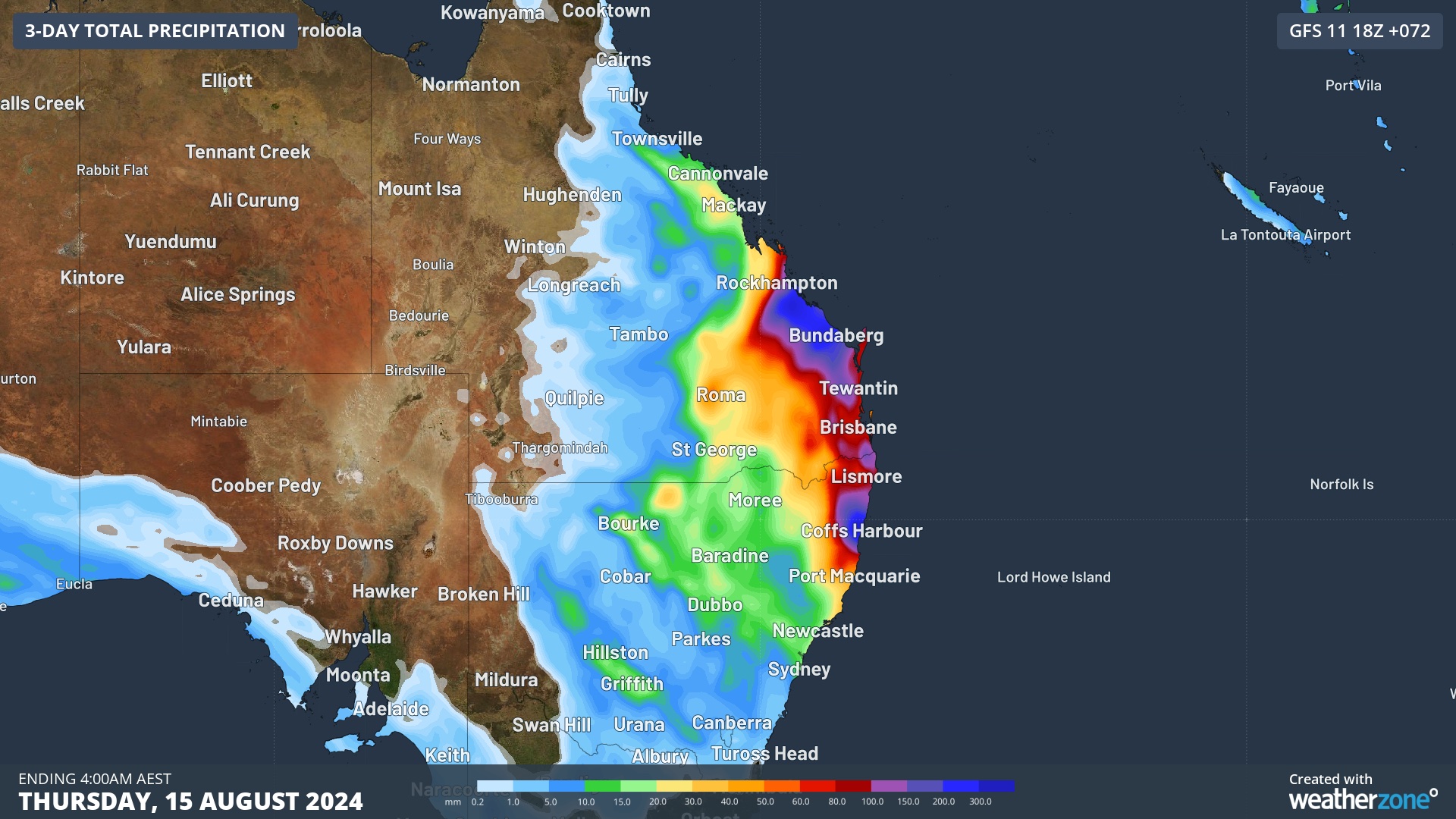
Image: Forecast accumulated rain during the 72 hours ending at 4am AEST on Thursday, August 15, 2024, according to the GFS model.
Some areas of central Qld and northeast NSW could see another 100-200 mm of rain over the next few days, on top of what’s already fallen. A few places might even pick up 200-300 mm, particularly where rainfall is enhanced by local topography or thunderstorms.
Rain will ease over central Qld from Wednesday and most other areas of eastern Australia by Thursday as the upper-level lows weaken and move offshore.
As of midday AEST on Monday, flood watches were in place for parts of central and southeast Qld and northeast NSW. Warnings were also in effect for heavy rain in northeast NSW and hazardous surf in southeast Qld. Be sure to check the latest warnings in Qld and NSW over the next three days.
Are increasingly volatile weather events affecting your insurance company’s bottom line?
Given weather affects your business at all levels of operation, from risk assessment to sales and claim management, it’s worth gaining the foresight of our industry-leading, comprehensive weather services.
DTN APAC, a DTN company, offers you trusted weather intelligence, alerting and analytics to support your business, bringing ease to your risk and claims management.
Severe weather and conditions alerting
Weatherzone’s alerting allows your organisation to mitigate severe weather insurance claims and protect policy holders from lightning, hail, bushfires and other natural disasters. Address specific SMS alerts are sent up to 30 minutes prior to a severe storm’s impact, giving your customers time to prepare themselves, protecting both assets and life. Our alerting system combines the proven technology of TITAN Tracks, with our own Dangerous Thunderstorm Alerts (DTAs) and Total Lightning Network, so you are protected by the most precise service available.
Historical severe weather reporting
StormQuery creates storm reports based on historical data from the Bureau of Meteorology and lightning strike information from our own Total Lightning Network. You can draw historical lightning and severe weather reports – geo-tagged to any address and postcode – to quickly and accurately verify severe weather insurance claims. StormQuery is seamlessly embedded within the Weatherzone interface and is easy to visualise and utilise.
Long-range forecasts
Long-range forecasts enable you to prepare for the seasons ahead – whether it’s tropical cyclone risk, La Niña’s above average rainfall or the bushfire seasons of El Niño. With that foresight, you can equip your customers with the strategies they need to mitigate loss due to fire, flood and severe weather. Nurture your relationship with your customers by providing them with the tools to protect themselves and their assets from increasingly volatile conditions. Data from the forecast reports can also be incorporated into your reinsurance negotiations.
Rain, hail or shine: we are there for you, and your customers. To find out more visit our contact page or email us at apac.sales@dtn.com.


