
Hailstorms are one of Australia’s most costly natural disasters. New research suggests that they are becoming more frequent in some of Australia’s cities.
What is hail?
Hailstones are made of layers of ice which form in thunderstorm updraughts. Hailstones grow larger by colliding with other rain droplets and ice particles in the updraft, until they become too heavy to remain suspended in the air and fall to the surface.
There are several ingredients required for large or giant hailstones to form;
- Sufficient supercooled liquid water in the atmosphere.
- A very strong up-draught allowing the hail to remain suspended in the air, enabling the stones to grow.
- Wind shear (change in wind direction and speed with height), can help create the types of severe thunderstorms that produce hail.
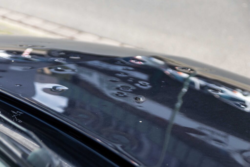
Hail varies in size, with the larger hailstones typically causing the most damage.
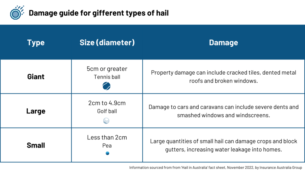
Severe thunderstorm warnings are issued in Australia for large hail above 2cm in diameter, and giant hail above 5cm in diameter.
Economic impact of hail in Australian cities
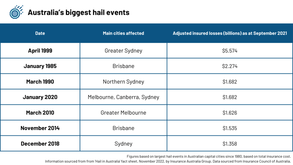
Hailstorms are common across Australia. They are costly natural hazard that can cause injuries and extensive damage to homes and property.
The table below shows that the Sydney hailstorm in 1999 was the most expensive hail event in Australia. 5.574 billion dollars of insured losses were recorded in September 2021.
This was one of the costliest events ever recorded for insurance companies, followed by the Brisbane hailstorm in 1986.
Trends in Australian hail events
A new study has found interesting trends in the number of hail days in Australian capital cities in recent decades.
The map below shows the trends in the annual number of hail prone days across Australian cities during the past four decades. The dominance of blue shading on the map shows that hail days have decreased for most of Australia. However, there are some areas where hail days have become more frequent, especially in the southeast and southwest.
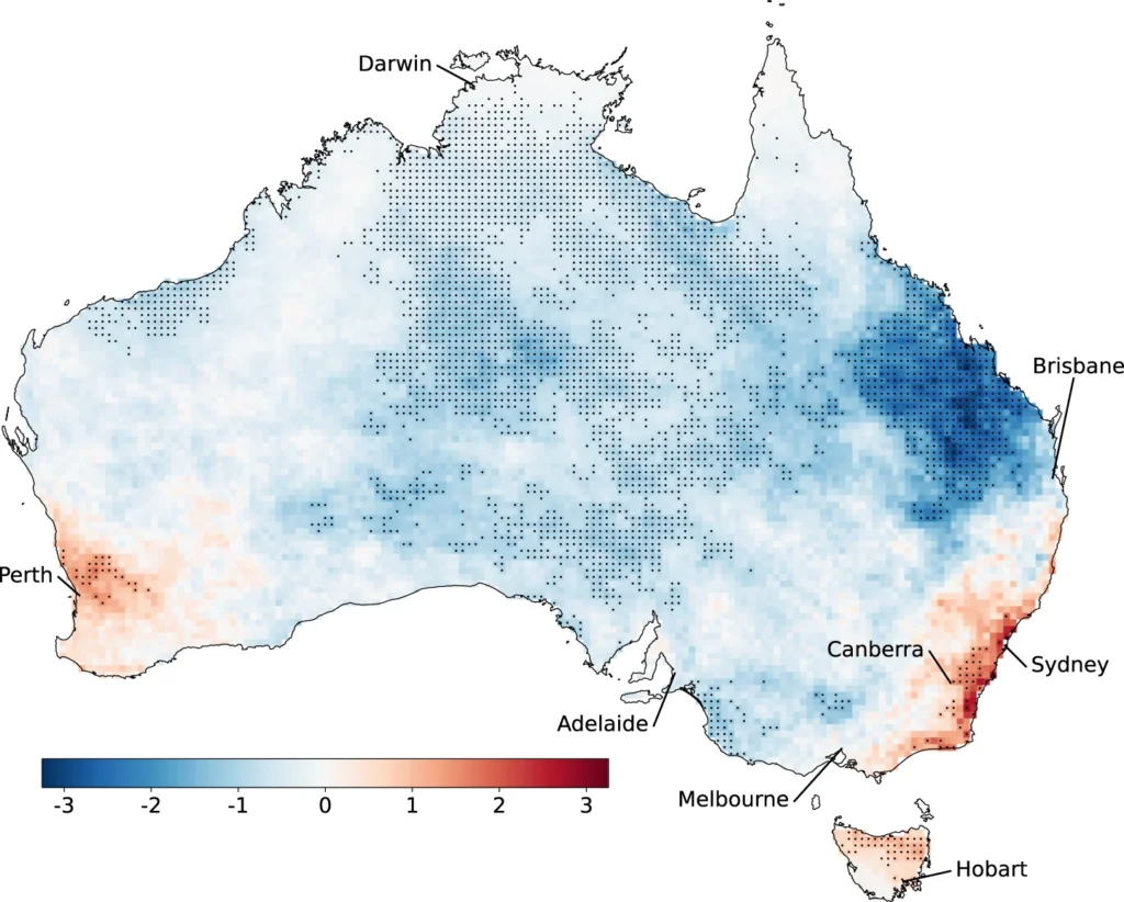
Image: Trends in annual hail-prone days (in days per decade) between 1979 and 2021. Sourced from ‘Changes in hail hazard across Australia: 1979–2021’ via npj Climate and Atmospheric Science (npj Clim Atmos Sci) | ISSN 2397-3722 (online)
Over the period from 1979 to 2021, the number of hail days has increased in Sydney, Perth, Canberra and Hobart. By contrast, Darwin and Adelaide have seen a reduction in hail days over the same period. The study found no statistically significant trends in hail days for Melbourne and Brisbane.
Hobart has seen the quickest increase in the number of hail days, with the capital observing around a 20% increase per decade between 1979 and 2021. Sydney, Perth and Canberra’s hail days increased by around 10% per decade over the same period.
While the study did not explicitly address changes in hailstone size, it noted that eastern and southeastern Australia has seen an increase in large hail in recent years.
How can Weatherzone help?
Given weather affects your business at all levels of operation, from risk assessment to sales and claim management, it’s worth gaining the foresight of our industry-leading, comprehensive weather services.
DTN APAC, a DTN company, offers you trusted weather intelligence, alerting and analytics to support your business, bringing ease to your risk and claims management.
Severe weather and conditions alerting
Weatherzone’s alerting allows your organisation to mitigate severe weather insurance claims and protect policy holders from lightning, hail, bushfires and other natural disasters. Address specific SMS alerts are sent up to 30 minutes prior to a severe storm’s impact, giving your customers time to prepare themselves, protecting both assets and life. Our alerting system combines the proven technology of TITAN Tracks, with our own Dangerous Thunderstorm Alerts (DTAs) and Total Lightning Network, so you are protected by the most precise service available.
Historical severe weather reporting
StormQuery creates storm reports based on historical data from the Bureau of Meteorology and lightning strike information from our own Total Lightning Network. You can draw historical lightning and severe weather reports – geo-tagged to any address and postcode – to verify severe weather insurance claims quickly and accurately. StormQuery is seamlessly embedded within the Weatherzone interface and is easy to visualise and utilise.
Long-range forecasts
Long-range forecasts enable you to prepare for the seasons ahead – whether it’s tropical cyclone risk, La Niña’s above average rainfall or the bushfire seasons of El Niño. With that foresight, you can equip your customers with the strategies they need to mitigate loss due to fire, flood and severe weather. Nurture your relationship with your customers by providing them with the tools to protect themselves and their assets from increasingly volatile conditions. Data from the forecast reports can also be incorporated into your reinsurance negotiations.
Rain, hail or shine: we are there for you, and your customers. For more information, please contact us at apac.sales@dtn.com.


