Rain and thunderstorms will hit part of every state and territory in Australia this week, with flash flooding a heightened risk amid the late-spring severe storm outbreak.
Several factors will align to cause prolific rain and thunderstorm activity over Australia this week:
- A hot air mass will linger over northern and eastern Australia, providing some of the energy required for storm development.
- A slow-moving upper-level trough will pass over southern Australia, causing a contrast between the hot air in the north and east and much cooler air in the south.
- An array of low pressure troughs over the Australian continent will act as triggers for daily thunderstorms.
- Warmer-than-average sea surface temperatures surrounding Australia will supply ample atmospheric moisture to fuel continuous rain and thunderstorm activity throughout the week.
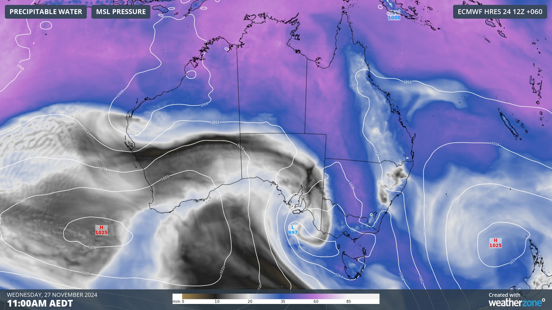
Image: Modelled precipitable water and mean sea level pressure at 11:00am AEDT on Wednesday, November 27, showing a large pool of moisture-laden air sitting over northern and southeastern Australia.
This week’s volatile weather set-up will result in widespread rain and thunderstorms that will see severe storms pummeling multiple states and territories in the final days of spring.
Where will the rain and storms occur?
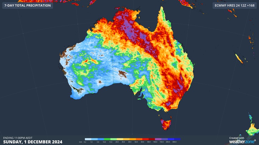
There aren’t many parts of Australia that will escape at least some wet weather in the last week of spring. The map below shows the predicted accumulated rain for this week from one computer model.
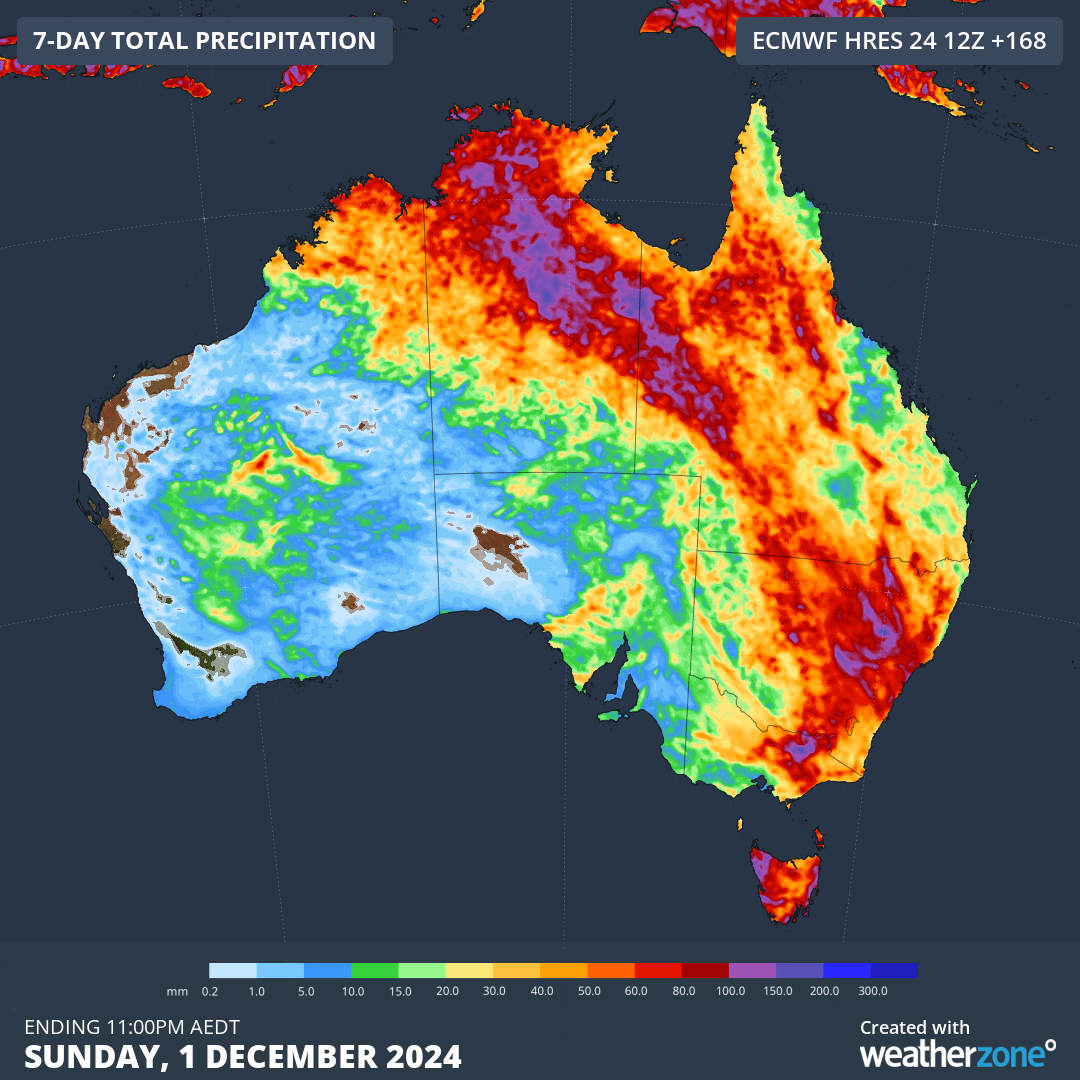
Image: Forecast accumulated rain during the week ending on Sunday, December 1, 2024.
Showers and thunderstorms will be a daily occurrence in northern Australia this week, impacting parts of WA, the NT and Qld.
Further south, rain and storms will pepper parts of southern and southeastern Australia early in the week before increasing and spreading further east through the middle and back end of the week.
While severe thunderstorms and areas of heavy rain are possible in every state and territory this week, the heaviest falls are likely to occur in a broad arc stretching across northern and eastern Australia, including parts of the NT, western Qld, NSW and possibly Vic, Tas and the ACT. Heavy rain and flash flooding will be a heightened risk with severe storms this week due to the abundance of atmospheric moisture that’s available.
Stormtracker is a severe weather solution that can assist you in observing, in real-time, any storm or event that has the potential to impact your business.
Embedded in DTN’s industry interfaces, the system gives you a time advantage when monitoring conditions developing over your infrastructure and location.
Stormtracker is our Global Information System (GIS) tracking tool, providing multiple weather layers and zoom controls overlaid on a map of your location and infrastructure. You can choose a snapshot or full screen view, depending on your requirements. The maps allow you to monitor all weather, and specifically any systems likely to cause risk for your business. You also have the capacity to observe:
- real time lightning and thunderstorm alerts
- localised lightning strike frequency
- official warnings for storm, cyclone, wind, flood and fire
- sentinel hotspot fires and fire agency current incidents
Stormtracker’s radar imagery updates every 10 minutes, so you are always able to respond rapidly to changing conditions. You can customise alerting to notify you when your staff or infrastructure are under threat. With increased situational awareness, your ability to make informed decisions quickly is optimised.
DTN’s experience and intelligence gives you a clear path through complex situations. Let us assist you, offering actionable insight when extreme weather poses risk to your business. For more information please visit our website or email us at sales.apac@dtn.com.


