An extremely hot air mass will cause temperatures to soar over a large area of Australia on Wednesday, with extreme fire danger anticipated in southwest Queensland and northwest Victoria.
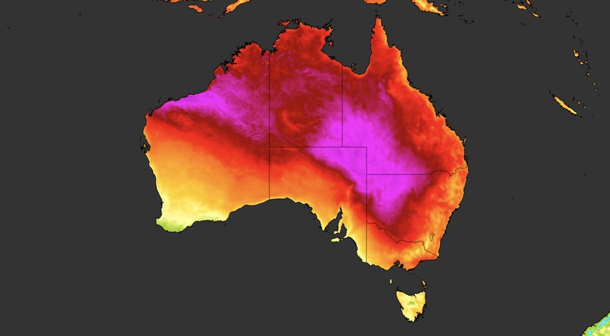
A broad trough of low pressure stretching across Australia is allowing a pool of late-spring heat to lie over parts of several states and territories this week, extending from the nation’s eastern interior to the north of WA.
This weather pattern is causing a multi-day heatwave that’s gripping parts of Qld, NSW, the NT and WA this week. At Birdsville in Qld, the mercury climbed to 45.2°C on Tuesday afternoon and only dropped to 31.7°C on Wednesday morning. By 9:40am on Wednesday, temperatures were already exceeding 40°C in parts of southwest Qld.
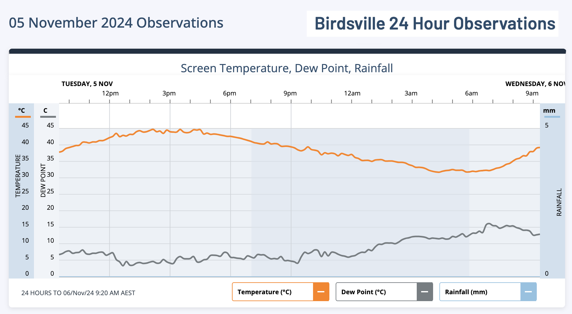
Image: Temperature observations at Birdsville, Qld during the 24 hours ending at 9:20am AEST on Wednesday, November 6, 2024.
Temperatures are predicted to reach the mid-forties in parts of five states and territories on Wednesday, including NSW, Qld, SA, WA and the NT.
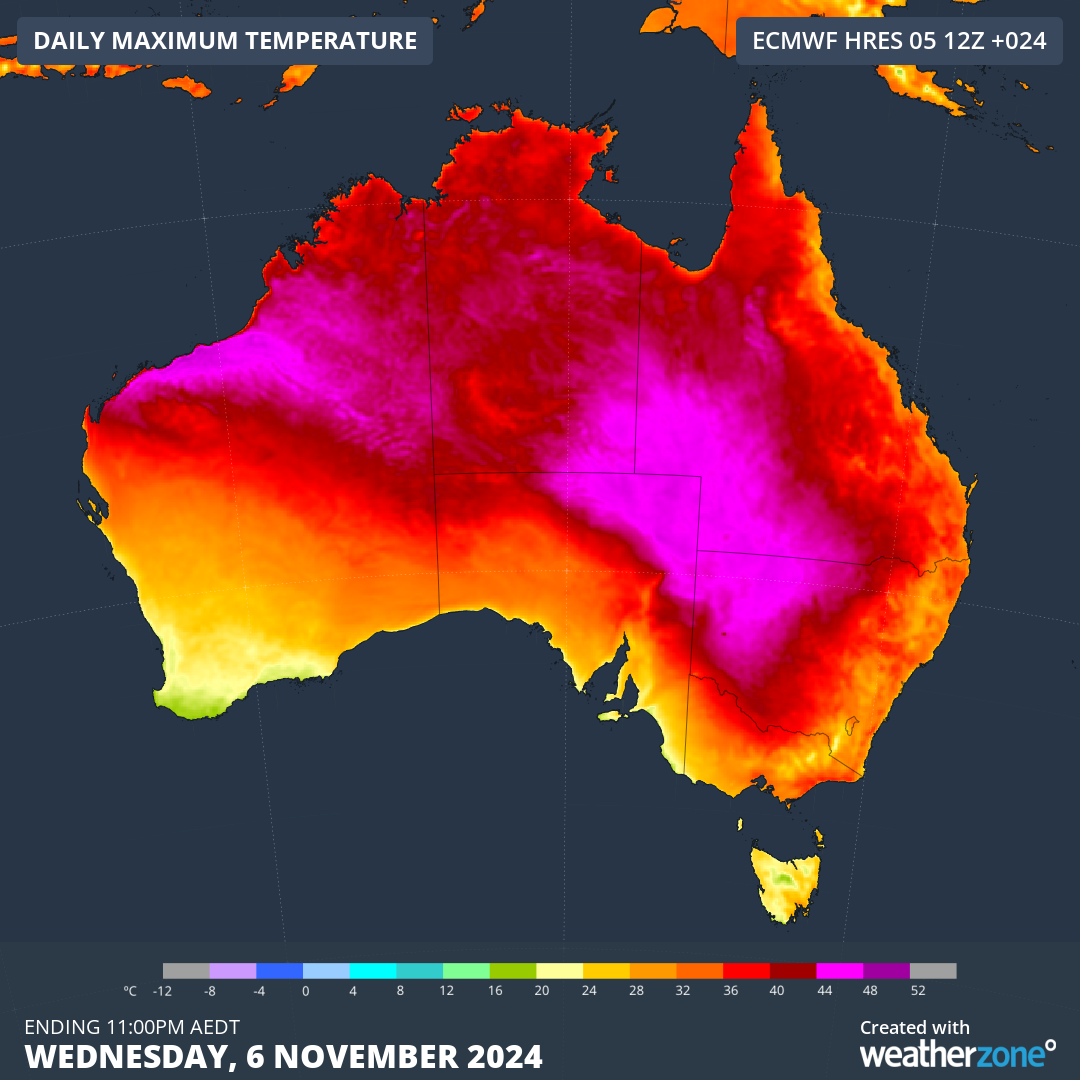
Image: Forecast maximum temperatures on Wednesday, November 6, 2024.
Wednesday’s hot weather will help elevate fire danger ratings in some parts of the country, with extreme fire danger ratings predicted in Qld’s Channel Country and the Mallee in Vic. Total fire bans have been issued in both regions, which is the first total fire ban of the season in Vic.
Fire authorities and emergency services in several states are closely watching a number of fires that were already burning as the sun rose on Wednesday. This includes a fire near Dirranbandi in southwest Qld, where residents have evacuated from their homes in response to the fire travelling towards the town.
While the heat won’t be quite as intense over Australia on Thursday, extreme fire danger ratings are expected to develop the North West fire weather district in NSW.
Check state and territory fire authority websites for the latest fire warnings and fire danger ratings.
Working in often severe conditions in the high-risk fields of forestry and emergency, our consolidated weather services can ensure full situational awareness for you and your team.
DTN APAC serves the forestry and emergency sectors, delivering trusted weather data and severe weather alerting to maintain safety, protect your assets and underpin your planning.
Weatherzone’s trusted nowcasting and forecasting system, OpticastTM, is independently proven to outperform other industry models, allowing you to respond rapidly to changing conditions. Opticast can ingest data from your on-site weather observation equipment, ensuring your forecast is customised to your local microclimate. From nowcasting and 14 day forecasting to seasonal outlooks, you have powerful, hyper-local weather alerting and intelligence, giving you decisive confidence when it’s most needed.
With lightning a prominent cause of forest fires throughout Australia, Weatherzone’s Total Lightning Network offers real-time detection and unsurpassed accuracy of lightning strikes to <200m. Based on a vast sensor network, both intra-cloud and cloud-to-ground strikes are located, ensuring you are alerted when severe weather is building and threatening your teams, assets and infrastructure. When volatile conditions increase the ferocity of fire it’s imperative you have lead-time to enact safety plans, keeping your people out of harm’s way.
Your weather intelligence is accessible across all devices in your network via our Weatherguard App, and your customisable interface.
We are there for you when you need us the most – 24/7, 365 days a year. For more information please visit our website or email us at apac.sales@dtn.com.


