Severe thunderstorms, tornadoes and flooding rainfall have disrupted transport, rail, aviation and many other industries across NSW as a low pressure system tracked over the state.
Severe thunderstorms and tornadoes in western NSW
A tornado was observed near the town of Young on the South West Slopes of New South Wales around 3:30pm on Wednesday afternoon, as severe thunderstorms spread across the state. Tornadoes can bring rapid and widespread destruction of homes, powerlines and derailing of trains and large road vehicles.
The tornado occurred as part of a severe thunderstorm outbreak, with the BoM updating its severe thunderstorm warning shortly afterwards to include a reference to the confirmed tornado. At 4:40pm (AEST), the BoM’s issued its latest severe thunderstorm warning for parts of the Hunter, Central Tablelands, Southern Tablelands, Central West Slopes and Plains, and South West Slopes forecast districts, warning of the risk of damaging winds, large hail and heavy rain. Severe thunderstorm warnings are visible on DTN APAC’s Stormtracker dashboards, allowing for rapid and efficient processing of which warnings could impact your business.
A pair of dramatic images of the tornado showing the classic funnel cloud twisting its way to ground level among the golden spring canola fields were captured by the New South Wales Rural Fire Service.
As several storms sweep across NSW this afternoon, there has been a report of a tornado near Young. These images were captured by a #RFS fire tower looking to the northwest of Young. pic.twitter.com/Iv2WkXelck
— NSW RFS (@NSWRFS) September 10, 2025
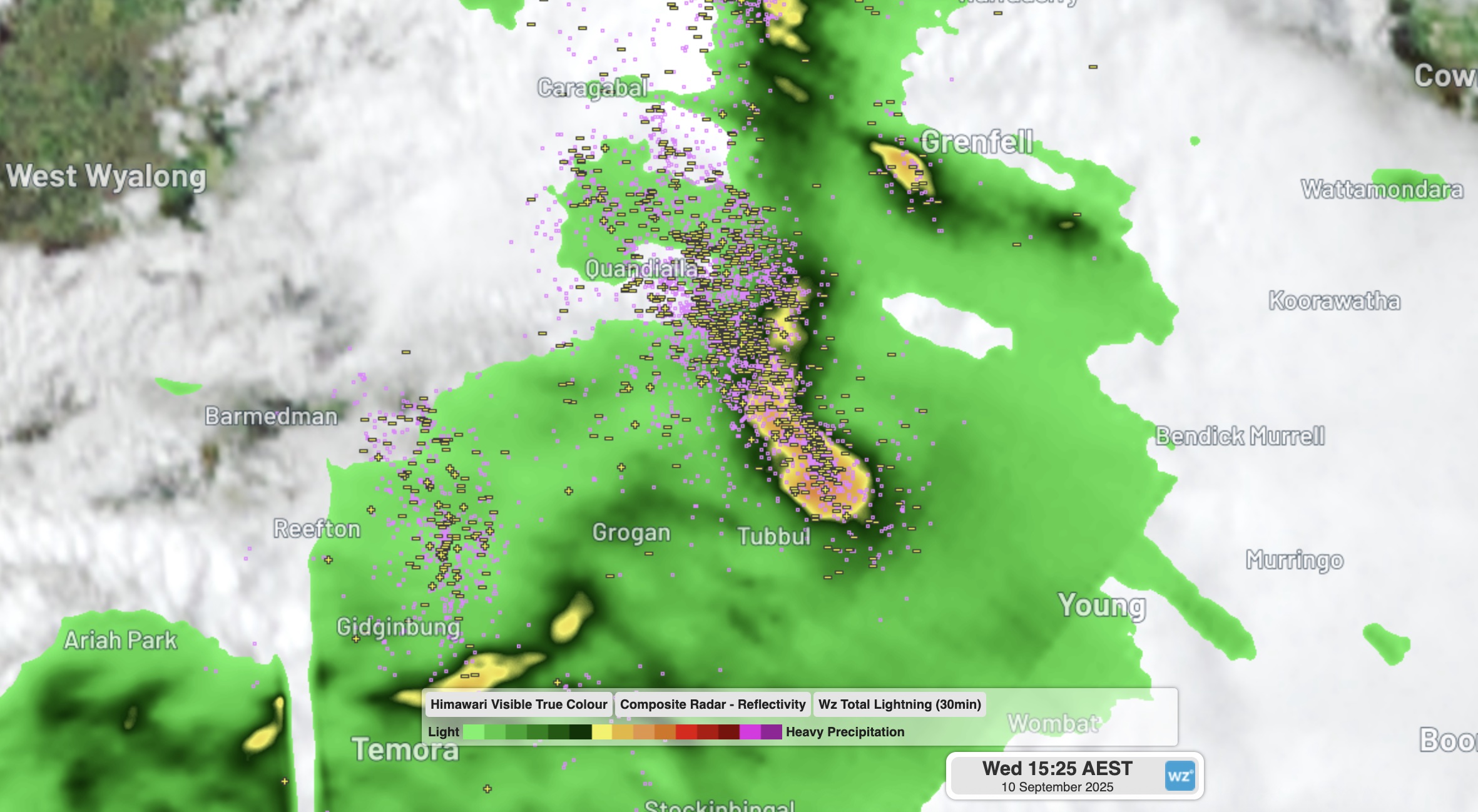
“The storm in which the tornado was embedded could also be seen on the weather radar, where the heaviest areas of rain (the red and yellow areas) just west of Young formed a hook shape which is a sign of a tornadic supercell,” DTN APAC Risk Communication meteorologist Joel Pippard explained.
“In the moments leading up to the tornado, the radar shows a supercell (red shading) just to the east of a line of storms. When the line of storms caught up to the supercell, it disrupted its structure and imparted a rotation on the storm. That created all the ingredients for a funnel cloud to descend to the surface to become a tornado.”
“The type of tornado was a rope tornado,” Pippard added.
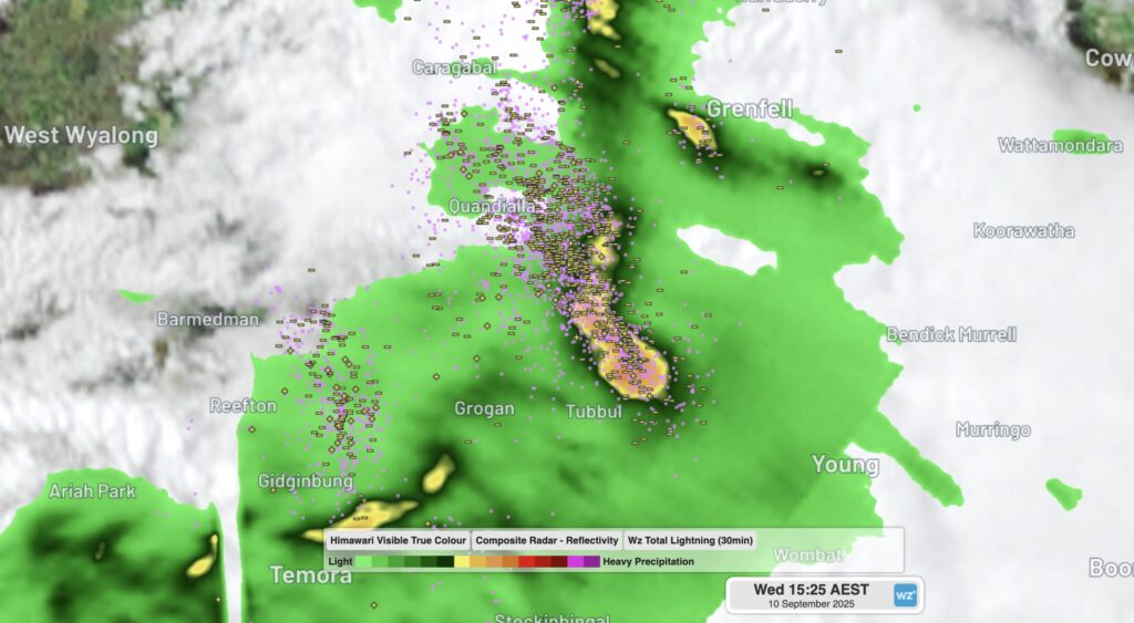
Image: DTN Stormtracker radar image showing the thunderstorm that produced the tornado northwest of Young, NSW, on Wednesday, September 10, 2025.
Flooding rainfall spreads east, bringing Sydney’s wettest September day in 146 years
The combined radar and satellite loop below shows the intense rainfall swirling around a low pressure system centred over the Sydney region between 7pm Wednesday and 7am Thursday. 72mm of rainfall was recorded during that 12-hour period.
Video: 12 hour combined satellite and radar loop for NSW up until 7am on Thursday September 11, 2025.
While there were a few rumbles of thunder in the Sydney region on Wednesday evening, this was a night of persistent heavy rainfall rather than the intense but brief rainfall which tends to be associated with storms.
Sydney, Canberra and Wollongong have all had their wettest day of 2025, while Sydney’s total of 122mm in the 24 hours to 9am Thursday was the city’s heaviest daily rainfall total for September since 1879. Flash flooding across the region has resulted in over 600 incident responses from NSW SES, including 34 flood rescues.
The unstable low pressure system fed by abundant atmospheric moisture which drenched Sydney also brought very high 24-hour rainfall totals to areas south and southwest of the Sydney basin, including:
- 46mm in Canberra, which was the national capital’s highest daily fall of 2025 to date.
- More than 130mm at numerous coastal weather stations south of Sydney, including Kiama, Bellambi and Jervis Bay.
- The highest NSW reading of 144.8mm was in Ulladulla, which is having a very wet year with a year-to-date rainfall total which is approaching double its running average. Ulladulla also had the wettest day anywhere in Australia in July 2025 when 224mm fell on July 2.
Flood warnings have been issued for three rivers in the Sydney Basin – the Nepean, the Georges and the Cooks – as heavy rain continues into Thursday morning.
This is a somewhat unseasonable weather system. September is typically the driest month of the year in Sydney, with a monthly rainfall average of 67.2mm which is almost exactly half that of the wettest month (March with 135.2mm).
The good news for flood affected businesses is that fine weather will return by Friday and stick around all weekend and well into the new week.
How DTN APAC’s Stormtracker can help your business
Embedded in DTN APAC’s industry interfaces, the system gives you a time advantage when monitoring conditions developing over your infrastructure and location.
Stormtracker is our Global Information System (GIS) tracking tool, providing multiple weather layers and zoom controls overlaid on a map of your location and infrastructure. You can choose a snapshot or full screen view, depending on your requirements. The maps allow you to monitor all weather, and specifically any systems likely to cause risk for your business. You also have the capacity to observe:
- real time lightning and thunderstorm alerts
- localised lightning strike frequency
- official warnings for storm, cyclone, wind, flood and fire
- sentinel hotspot fires and fire agency current incidents
Stormtracker’s radar imagery updates every 5 minutes, so you are always able to respond rapidly to changing conditions. You can customise alerting to notify you when your staff or infrastructure are under threat. With increased situational awareness, your ability to make informed decisions quickly is optimised.
DTN APAC’ experience and intelligence gives you a clear path through complex situations. Let us assist you, offering actionable insight when extreme weather poses risk to your business.
Learn more about our large range of industry leading products and services or email us at sales.apac@dtn.com


