Fierce winds are expected to lash parts of Vic, Tas, the ACT and NSW early next week, bringing the risk of wind farm cut outs in the region.
A low-pressure system should develop early next week near Vic and NSW as a cold front interacts with tropical moisture.
This cold front will sweep across SA on Monday and approach Vic later in the evening, bringing strong and gusty winds to both states. Models suggest that these winds will be just the right strength, with the states likely to harness decent wind power on Monday.
The map below shows one model forecast wind gusts on Monday afternoon.
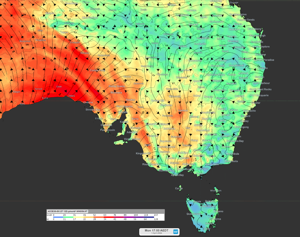
Image: Instantaneous wind gust forecast at 5pm on Monday, April 1, according to Access-G
While strong winds are usually great news for wind farms, the wind speeds on Monday evening and Tuesday could be too strong. There is a sweet spot when it comes to wind power.
Wind gusts above 90km/h (25m/s) can damage the wind turbines and the propellers if they are spinning in these winds.
Most wind farms turn off the turbines if the wind speed reaches the ‘cut off’ wind speed of 90km/h (25m/s) to prevent damage to the turbines.
Unfortunately, if the propellers are turned off on the turbines due to high winds, wind power is not being harnessed. During these periods of intense winds, wind power capacities will be reduced if the turbines remain turned off.
Late Monday into Tuesday, there are early indications that damaging wind gusts could impact parts of Vic, Tas, NSW and the ACT. These winds could exceed the criteria of 90km/h forcing some wind farms to turn the propellers off and reducing the capacity. There is still some uncertainty in the strength and location of these damaging winds, due to varying positions of the low.
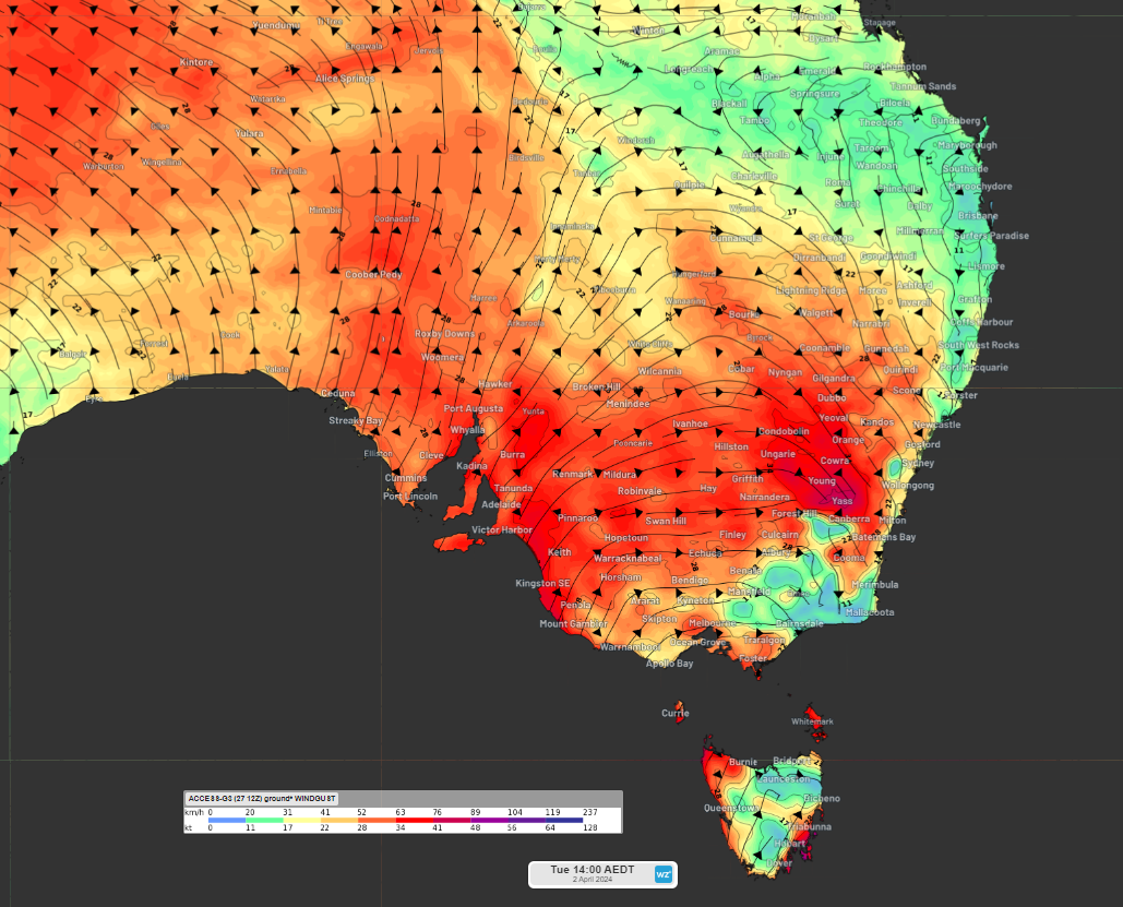
The map below shows one models wind gust forecast on Tuesday afternoon, with winds remaining strong but not too strong in SA.

Image: Instantaneous wind gust forecast at 2pm on Tuesday, April 2, according to Access-G
The low-pressure system is also expected to bring heavy rainfall and thunderstorms which could increase the strength of these winds further in the region on Tuesday.
While the winds should ease on Wednesday as the low-pressure system moves further east in the Tasman Sea, the rainband and thunderstorms will move north through NSW and Qld during the middle of next week. Please keep an eye out for the latest warnings here, as this event unfolds.
DTN APAC delivers industry-leading weather and power generation forecasting and real-time alerting to inform your critical decision-making. Together we can keep your staff and assets safe, and efficiency high.
With lightning strikes, severe weather, flood and fire posing risk to wind farms across Australia, we have tailored solutions that can significantly improve your oversight and response.
Total Lightning Network comprises of regional and global sensors to detect intra-cloud (IC) and cloud-to-ground lightning (CG) strikes within your proximity thresholds. It provides unparalled detection accuracy (<200m) and real-time lightning alerts to any device across your operations team.
Your customizable Energyzone interface and Weatherguard app will provide access to the Total Lightning Network as well as centralized data from state and territory fire agencies, the Bureau of Meteorology, and over 30 national and international private and state organisations. This enables full situational awareness of weather conditions and fire risk, as well as severe weather alerting via text, email and phone call, so your staff can respond effectively when required. For more information, please contact us at apac.sales@dtn.com.


