
A cold front swept through Sydney in the early hours of Sunday morning, but the temperature is four degrees warmer than on Saturday. So why is it warmer after the front?
The cold front did indeed bring in colder air. The airmass temperature at about 1.5km elevation was 14°C on Saturday afternoon. On Sunday, it had fallen to 10°C, and will continue to fall as we move into the afternoon and evening.
Certainly, it has been cold in the south. Adelaide was a crisp 14.5°C at 2pm, exactly 10 degrees colder than the November average. Melbourne just cracked the 20-degree mark but hasn’t felt any warmer than 17 degrees all day.
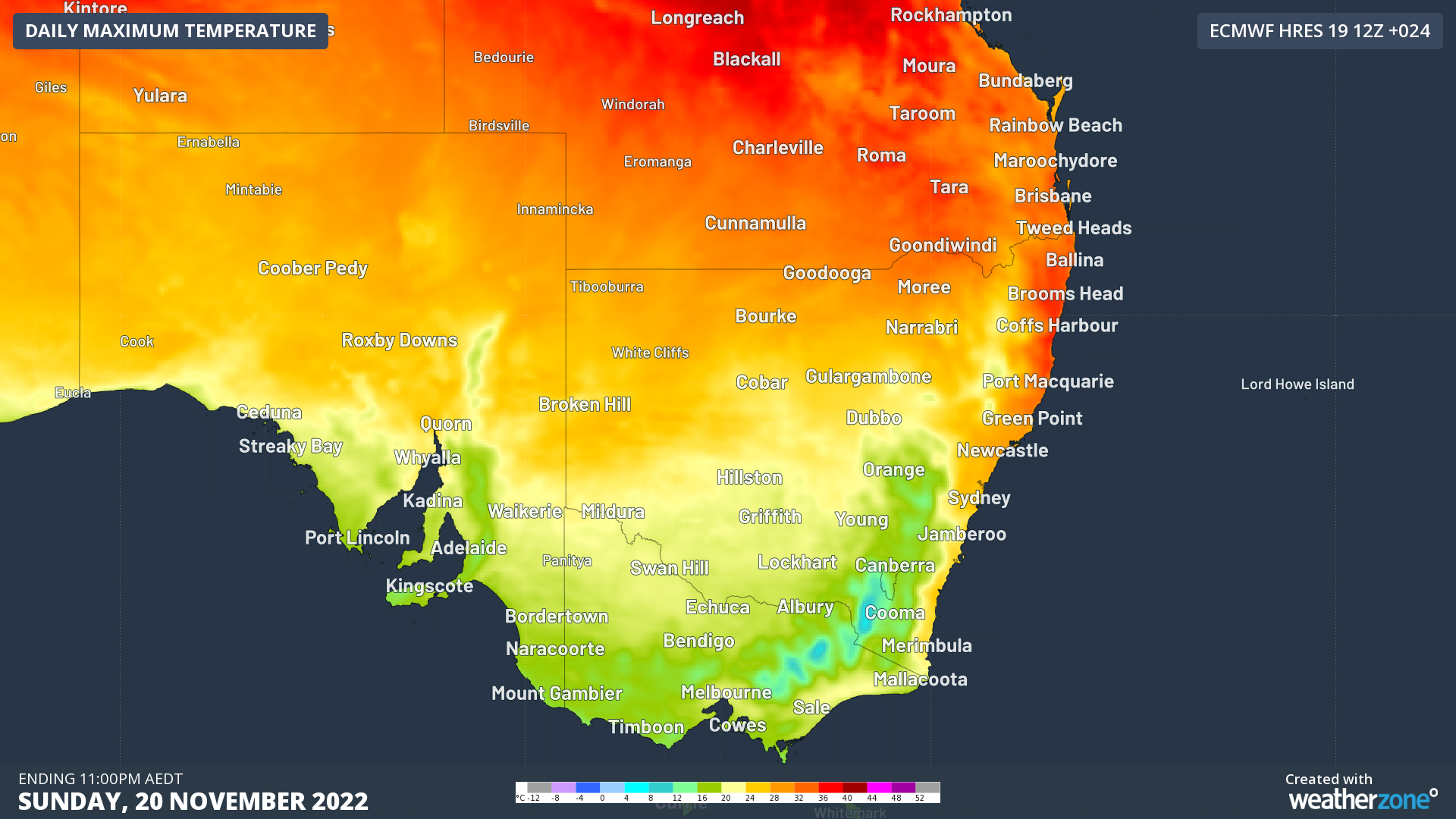
Sydney, on the other hand, reached 27.4°C just before 1pm, four degrees warmer than Saturday’s top and three degrees warmer than the November average. Due to the gusty dry winds and warm temperatures, Sydney has a ‘high’ fire danger rating in place today.
So why was Sydney so warm?
The secret is all in the wind direction. Before the front, winds were reasonably light from the north. That is a favourable direction for a cooling northeasterly seabreeze to form.
After the strong cold front, the winds turned to a westerly direction. This direction directly combats the cooling seabreeeze, preventing it from forming.
Another reason why a westerly wind is warmer is due to the Foehn Effect (pronounced like ‘fern’). This effect occurs when a strong wind blows off a mountain range and descends the other side. When the air descends, it heats up rapidly at a rate of about 10°C for every 1000m it drops (known as the dry adiabatic lapse rate). For Sydney, the mountain range involved is the Blue Mountains, allowing westerly winds to warm up quickly.

Image: Maximum temperatures on Sunday, showing the warmer conditions in eastern NSW and Qld compared to the rest of the southeast.
Sydney is not alone with experiencing warm winds after a cold front on Sunday and Monday. Brisbane is looking at back-to-back days in the mid-thirties, with parts of the Central Coast of Queensland facing severe heatwave conditions. All these locations would normally receive a cooling seabreeze but the westerly winds coming off the Great Dividing Range are acting to raise the mercury.
Temperatures will cool down over the next few days in the east as the airmass cools further and seabreezees start to form once again, although more heat could be on the way next weekend.
DTN APAC provides temperature forecasts all around Australia up to 14 days in advance through its Opticast forecasting system. To find out more, please email us at apac.sales@dtn.com.




