A weeklong stretch of warm and uncomfortable nights is on the horizon for Brisbane, with temperatures soaring and heatwave conditions forecast for the city in the next few days.
A broad low pressure trough stretching across Australia is allowing a pool of late-spring heat to lie over Qld for several days.
The map below shows severe heatwave conditions across large areas of Qld, including parts of Brisbane, as temperatures soar into the mid 30s and low 40s across much of the state.
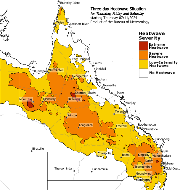
Image: Three-day heatwave forecast from Thursday, November 7. Source: BOM
The Bureau of Meteorology defines a heatwave as three or more days in a row when both daytime and night-time temperatures are unusually high. While this is a forecast for the next three days, the minimum temperatures are forecast to be 3 to 6°C above average over the next week.
Early Thursday morning the temperature only dropped to 21.7°C, which is just a taste of the week to come. Brisbane is forecast to see the warmest run of November nights in five years, with four nights at or above 22°C.
The warmest night is expected to be Thursday night with 24°C, followed by 23°C Friday night, 23°C Saturday, 22°C Sunday, 21-22°C Monday and 20-22°C Tuesday. There is a chance that Brisbane could meet or break the November record of 5 minimum temperatures at or above 22°C set during 2019 and 2009.
The map below shows the minimum temperature forecast Thursday night into Friday morning, with temperatures forecast to reach the mid 20s to low 30s.
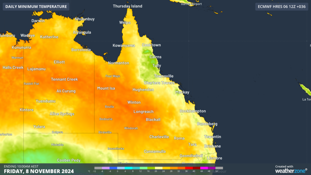
Image: Minimum temperature forecast for Friday morning, November 8, according to ECMWF
Meanwhile daytime temperatures over the next three days should be around 5 to 8°C above the November average, with the following maximums forecast:
- Thursday- 33°C Brisbane, 34°C Archerfield
- Friday- 34°C Brisbane, 26°C Archerfield
- Saturday- 32°C Brisbane, 33°C Archerfield
- Sunday- 30°C Brisbane, 31°C Archerfield
- Monday-29°C Brisbane, 30°C Archerfield
The heat is peaking on Friday, with the humidity across the city expected to make the temperature feel around 3°C hotter than actual on Friday and Saturday.
The heat will peak early Friday and Saturday afternoons, before a welcome seabreeze arrives and cools temperatures slightly.
Looking ahead, daytime temperatures will trend closer to average early next week, while nighttime temperatures will remain warm in the forecast period.
Weatherzone Business has grown to become the outright leader within the Australian energy market, serving wind, solar, hydro, trading, utilities and network companies.
You can’t control the weather, but you can gain precision insights to optimise your response. What lights us up is providing your energy business with tailored weather information to reduce your risk and keep you moving ahead of the curve.
Our services cover all aspects – from wind and solar generation to demand forecasts, wholesale markets to retail so, no matter where your company sits, we have solutions for you. We have worked closely with market participants to create products that meet the evolving needs of the sector, aiming to increase safety and profitability for our customers.
Benefit from the timely delivery of accurate weather information, allowing informed and effective decision-making. For more information please visit our website or email us at sales.apac@dtn.com.
Thumbnail image: EyeEm Mobile GmbH


