
A wave of warm air will sweep across Australia this week, sending temperatures to their highest levels in months in several states and territories.
A high pressure system sitting over southeastern Australia at the start of this week will allow a hot air mass to build over WA.
This heat will send temperatures into the mid-to-high thirties over a broad area of WA as northerly winds drag hot air from the state’s interior towards the south coast.
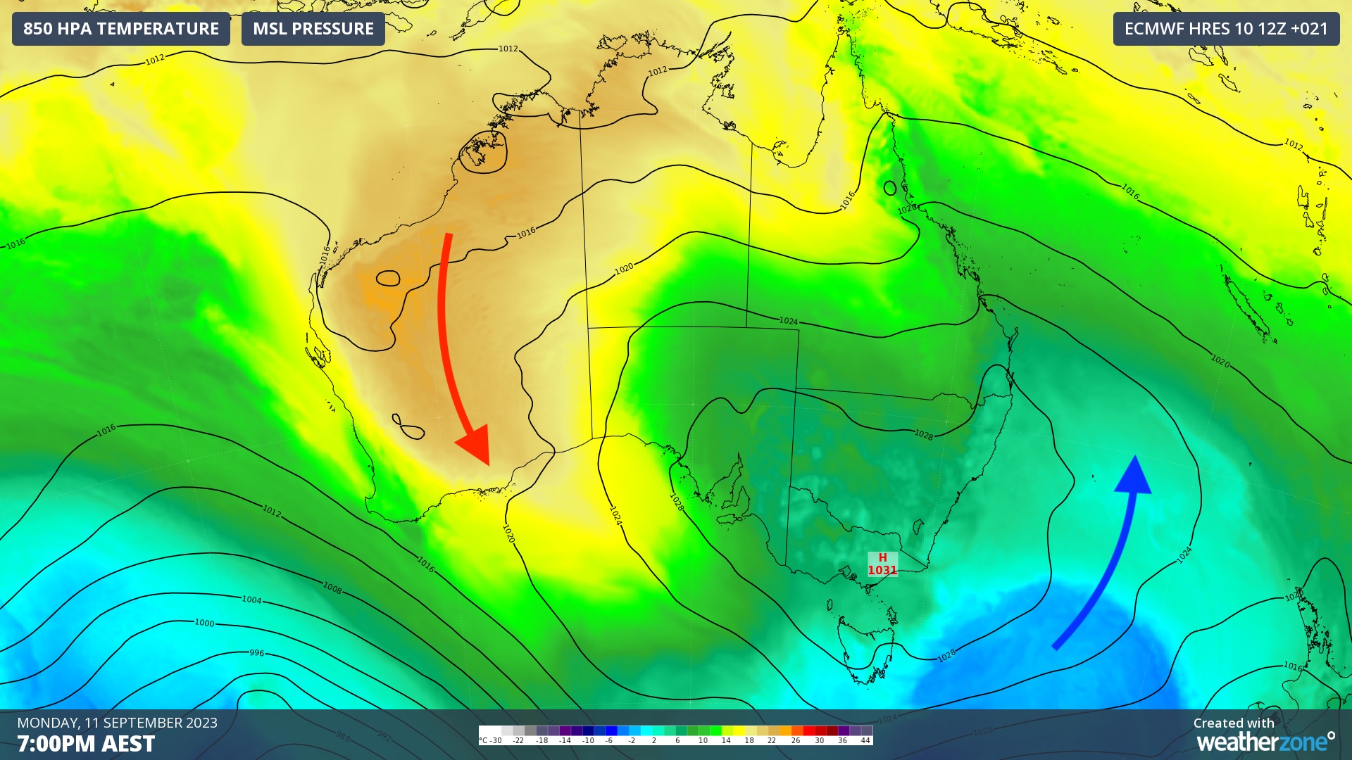
Image: Modelled mean sea level pressure (MSLP) and 850 hPa temperatures, annotated with arrows, showing how a high pressure system centred over southeastern Australia on Monday is helping a hot air mass build and spread over WA.
Kalgoorlie is forecast to reach 34 to 35ºC on Monday and Tuesday respectively, while Marble Bar could hit 36 and 37ºC on these days. For Kalgoorlie, this is close to 10ºC above average for this time of year and within 2ºC of its September record.
After baking WA early in the week, the hot air mass will start to spread across southern and central Australia on Wednesday and Thursday, before drifting across eastern Australia towards the end of the week.
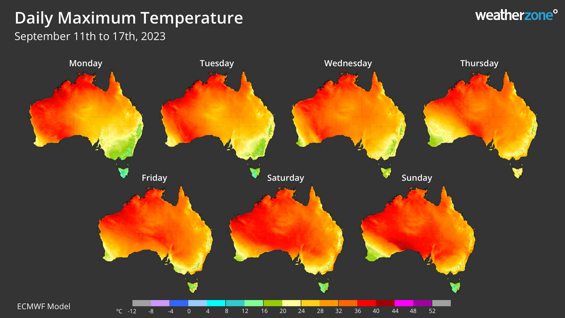
Image: Predicted daily maximum temperatures this week, showing hot air spreading across the country from west to east.
Most of Australia’s state capital cities will get a taste of early-season heat as the warm air mass spreads across the country from west to east this week:
- Adelaide will warm to the mid-twenties from Tuesday and could reach around 28ºC by Thursday.
- Melbourne could see a four-day stretch reaching 24 to 26ºC from Wednesday until Saturday.
- Hobart should see a few days in the low to mid-twenties from Wednesday to Friday
- Canberra will warm up in the back end of the week, possibly reaching 25 to 27ºC each day from Thursday to Sunday
- Sydney could see temperatures rise to the mid to high twenties from Thursday and possibly nudge 30ºC in the city on Saturday and Sunday. Some western suburbs could hit 35ºC on the weekend.
- Brisbane will only see the edge of this warm air mass, possibly climbing to the high twenties on the weekend
While it is still early in the fire season, this week’s hot weather may briefly elevate fire danger ratings in some parts of the country. You can check the latest fire information on your state or territory’s fire service website.
Weatherzone operates Opticast, an ultra-local forecasting system, independently proven to be the best performing of its type in Australia. Providing an unprecedented level of accuracy and precision, Opticast rapidly updates every 10 minutes, intelligently adapting to local observations, and corrects forecasts based on historical evidence. Wherever you are based, we can provide you with the most accurate nowcasting and forecasting data out to 14 days so that you can mitigate operational and safety risks, and plan to make the most of severe weather windows. For more information, please contact us at apac.sales@dtn.com


