
Parts of Australia could reach the mid 30’s this week, as warm and gusty westerly winds bring some early spring weather to the southeastern states.
Several cold fronts and low pressure systems will sweep across southern Australia this week, bringing warm and gusty westerly winds and rain to parts of southern Australia. While a stubborn high pressure system and clear skies allows temperatures to build in central Australia.
The map below shows that parts of central Australia are forecast to see weekly temperatures reach around 9°C above average, as warm air pools in the region.
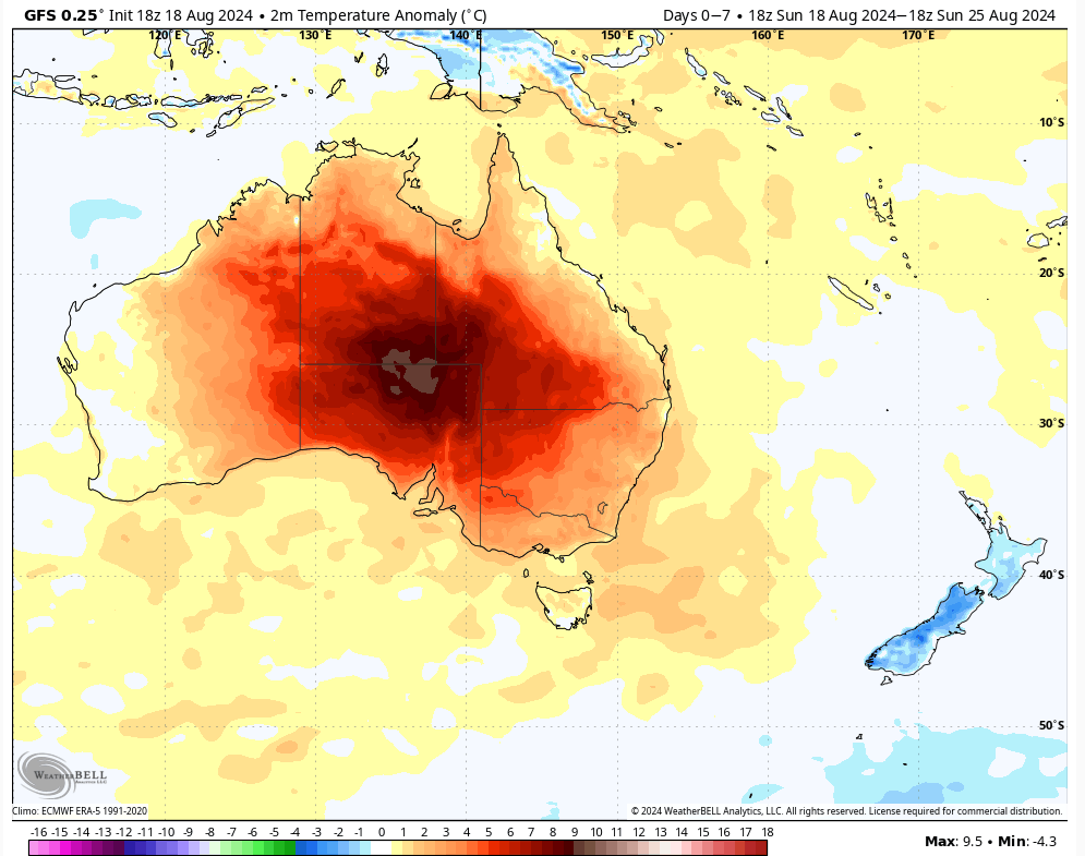
Image: 2m temperature anomaly forecast for the week leading up to Sunday, August 25, according to GFS. Source: WeatherBELL
Temperatures across much of Australia should be warmer than average each day this week, despite cold fronts impacting southern Australia. The cold polar airmasses that you typically see behind these cold fronts are not reaching Australia this week and are slipping further south.
While most of the week should bring warm winter temperatures, there are two pulses of warm air that will impact the southeastern states mid and late this week. Overnight temperatures should also be warm this week, with minimums in Sydney only dropping to around 14 to 15°C early Wednesday morning.
The first mid-week pulse will see temperatures in Sydney rise to around 24 to 25°C on Wednesday, which is around 6 to 7°C above the August average.
The second and more significant burst of warmth is set to impact the southeastern states on the weekend, with some areas of SA to reach around 15 to 18°C above average.
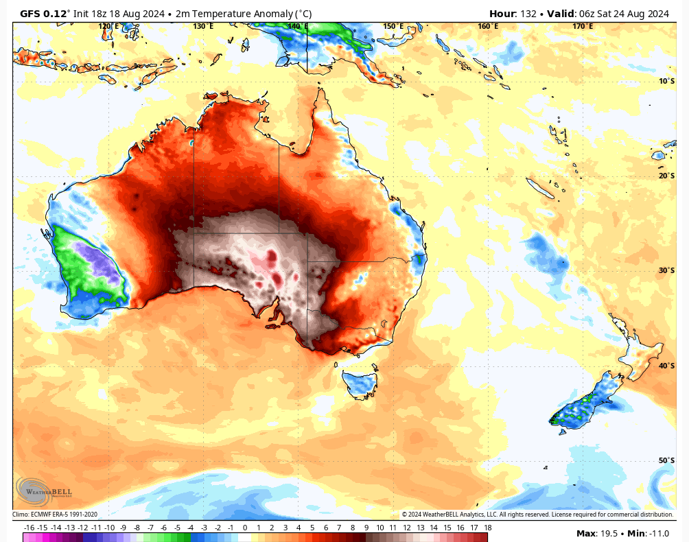
Image: 2m temperature anomaly forecast for 4pm Saturday, August 24, according to GFS. Source: WeatherBELL
Parts of central Australia could break August heat records this week. Alice Springs is expected to reach 35°C this Friday and Saturday, and there’s every chance that its August record temperature of 35.2°C (which is also the record winter high) could be exceeded. Also in northern SA, Oodnadatta (which holds Australia’s equal-highest temp on record in any month of 50.7°C) is heading for a pair of 36-degree days on Friday and Saturday. Its winter record, as well as the state winter record, is 36.5°C.
While much of the weekend’s heat lingers in central Australia, the southeastern states capital territories should also see temperatures creep up to 5 to 8°C above average:
- Adelaide’s maximums on the weekend should be around 23 to 25°C ahead of the cold front
- Melbourne’s daytime temperature is forecast to be around 20 to 23°C on the weekend
- Sydney’s temperature should peak at 23 to 24°C on Sunday, while Bankstown could reach 26°C
This warmth is being caused by several cold fronts generating strong and gusty westerly winds ahead of them.
The images below show several swathes of strong wind moving over southern Australia this week, with the strongest winds expected this weekend.
Image: Instantaneous wind gust forecast for the 7 days leading up to Monday, August 26.
The cold front sweeping across southern Australia on the weekend looks like the strongest of the week, which should produce decent wind power for the National Electricity Market on the weekend.
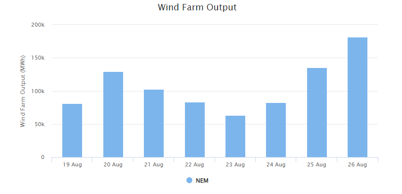
Image: Weatherzone’s National Electricity Market wind farm output forecast for the next 7 days leading up to Monday, August 26.
There are signs that the cold front coming this weekend could produce damaging winds across several states and territories which has the potential to cause wind farm ‘cut outs’.
Generally, cut outs occur when wind speeds exceed 90km/h (25 m/s), which is when the wind turbines are turned off to prevent damage.
While the prevailing westerly winds will keep much of central and northern Australia dry this week, the southern states should see some decent rain totals.
Parts of southwest WA, and western Tas could see weekly totals reaching 80 to 100mm by Sunday, August 25.
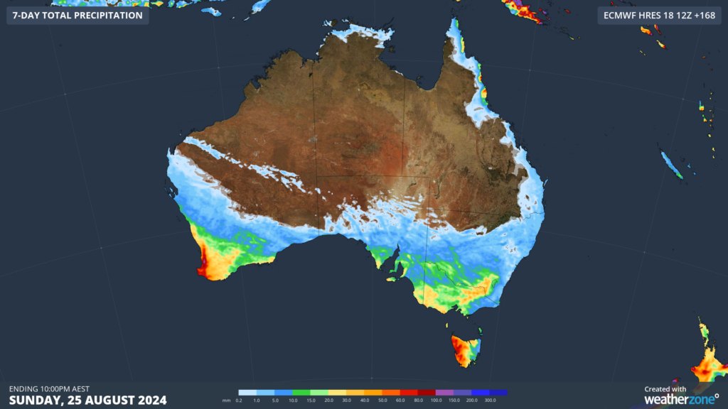
Image: Accumulated rain forecast for the 7 days leading up to 10pm Sunday, August 25.
Meanwhile parts of southern SA, Vic, NSW and the ACT could see totals reaching around 20 to 40mm this week. Some of these falls are expected to be in thunderstorms which unfortunately means they could be hit and miss. Severe thunderstorms could also form across parts of NSW and Vic on Tuesday, potentially producing damaging wind gusts.
Looking ahead, a strong cold front during the middle of next week could interrupt this early spring weather with a cold polar airmass.
Weatherzone Business has grown to become the outright leader within the Australian energy market, serving wind, solar, hydro, trading, utilities and network companies.
You can’t control the weather, but you can gain precision insights to optimise your response. What lights us up is providing your energy business with tailored weather information to reduce your risk and keep you moving ahead of the curve.
Our services cover all aspects – from wind and solar generation to demand forecasts, wholesale markets to retail so, no matter where your company sits, we have solutions for you. We have worked closely with market participants to create products that meet the evolving needs of the sector, aiming to increase safety and profitability for our customers.
Benefit from the timely delivery of accurate weather information, allowing informed and effective decision-making. To find out more visit our contact page or email us at apac.sales@dtn.com.




