
Extremely hot conditions across several states and territories has caused energy demand to soar on Monday, with extreme fire danger and the potential for severe thunderstorms on the cards.
The heat is being caused by hot northerly winds from the interior of Australia moving over the country’s southeast, ahead of a cold front and southerly change that will sweep across parts of southern Australia later on Monday and on Tuesday for eastern NSW and the ACT.
These conditions have led to a particularly sweaty night for Adelaide with the city recording a minimum of 29.6°C at 10:42pm Sunday evening, it hasn’t been warmer overnight in four years. The temperature didn’t cool quickly from there with it still sitting at 33°C at midnight and by 9am on Monday morning it was sitting at a hot 36°C.
The maximum temperature this afternoon will reach the mid to high 40s across parts of SA, Vic, NSW, Qld on Monday.
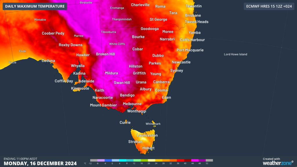
Image: Maximum temperature forecast on Monday, December 16, according to ECMWF
The temperature will peak at 6 to 12°C above average across southeastern Australia on Monday, with the capital’s maximums forecast to reach;
- 38°C in Adelaide, before a southerly change arrives around 8 to 10pm bringing cool relief.
- 41°C in Melbourne, before a cool change arrives between 11pm and 1am.
- Nearly 32°C in Hobart
- 37°C in Canberra
- 33 to 36°C in western Sydney on Monday, low 40s on Tuesday before a cool change arrives between 7 and 9pm. Temperatures on both Monday and Tuesday will feel around 3°C hotter than the actual temperature due to high levels of humidity.
The heat across the National Electricity Market (NEM) will drive possibly the highest energy demand in nearly four years, according to WattClarity.
The hot, dry and windy conditions are generating extreme fire danger across parts of southeastern SA and western Vic on Monday. A total fire ban has been issued for large parts of Vic and SA on Monday.

Image: Forecast fire danger on Monday, December 16. Source: Bureau of Meteorology
These conditions could be made even more dangerous by the potential for high based thunderstorms, which could come with little or no rainfall. This is called dry lightning, which can spark bushfires in hot and dry conditions such as today. These thunderstorms also may become severe, generating damaging wind gusts across parts of the state.
It is also worth noting that parts of southeastern SA and western Vic have been experiencing rainfall deficiencies this year, meaning that there is abundant dry matter and plant material which is highly flammable.
Looking ahead to Tuesday, temperatures will drop into the 20s across Vic and SA, while heat will peak in NSW. Fire danger should ease slightly with parts of southeastern Australia expecting High fire dang.er rather than Extreme.
Working in often severe conditions in the high-risk fields of forestry and emergency, our consolidated weather services can ensure full situational awareness for you and your team.
DTN APAC serves the forestry and emergency sectors, delivering trusted weather data and severe weather alerting to maintain safety, protect your assets and underpin your planning.
Weatherzone’s trusted nowcasting and forecasting system, OpticastTM, is independently proven to outperform other industry models, allowing you to respond rapidly to changing conditions. Opticast can ingest data from your on-site weather observation equipment, ensuring your forecast is customised to your local microclimate. From nowcasting and 14 day forecasting to seasonal outlooks, you have powerful, hyper-local weather alerting and intelligence, giving you decisive confidence when it’s most needed.
With lightning a prominent cause of forest fires throughout Australia, Weatherzone’s Total Lightning Network offers real-time detection and unsurpassed accuracy of lightning strikes to <200m. Based on a vast sensor network, both intra-cloud and cloud-to-ground strikes are located, ensuring you are alerted when severe weather is building and threatening your teams, assets and infrastructure. When volatile conditions increase the ferocity of fire it’s imperative you have lead-time to enact safety plans, keeping your people out of harm’s way.
Your weather intelligence is accessible across all devices in your network via our Weatherguard App, and your customisable interface.
We are there for you when you need us the most – 24/7, 365 days a year.For more information please visit our website or email us at sales.apac@dtn.com.


