
Sydney is now having one of its wettest Januarys since the 1980s after intense thunderstorms dumped half a month’s worth of rain in just one hour on Monday evening.
Most Sydneysiders started 2023 with hopes that the flood- and mould-producing rain of 2022 was a thing of the past. But with La Nina still in place and a warm East Australian Current boosting atmospheric moisture over eastern NSW, Sydney has just endured yet another abnormally wet month.
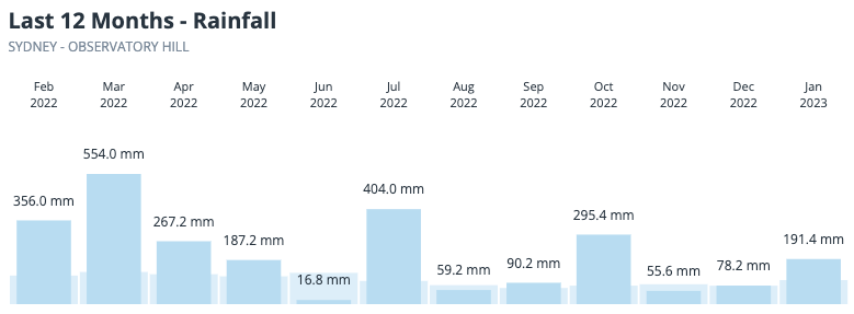
Image: Observed monthly rainfall at Sydney Observatory Hill, relative to the long-term average, during the past 12 months.
The latest downpour came from severe thunderstorms that swept over eastern NSW on Monday afternoon and evening, delivering 20 to 90 mm of rain to large areas of the Sydney Basin.
Sydney’s heaviest rain from Monday’s storms fell to the southwest of the city, where Camden collected 88mm at the airport, including 61 mm in 60 minutes. The city’s main rain gauge at Observatory Hill copped 52mm between 5:20pm and 6:20pm, which is half a month’s worth of rain in one hour.
The humidity has burst in Sydney, with the exact amount of rain it felt like was sitting in the air for the last three days. #sydney #sydneysummer #summerstorm pic.twitter.com/ZNc8TsuY7E
— DameSupsy (@DameSupsy) January 30, 2023
Monday night’s rain caused flash flooding in some parts of Sydney, temporarily blocking roads and halting peak hour public transport.
⚠️ Trains are not running between Sydenham and Bankstown in that direction only due to flooding on the tracks at Marrickville.
Delay travel if possible or consider using other transport.
Train services to the City will still run.
1/2
— T3 Sydney Trains (@T3SydneyTrains) January 30, 2023
Last night’s downpour brings the monthly total at Sydney’s Observatory Hill up to 191.4 mm, which is close to double the long-term monthly average of 101 mm. This was Sydney’s wettest January since 2016 and its second wettest since 1988. In 165 years of records, only 16 Januarys have seen more rain than this one.
It was also an unusually cool start to the year in Sydney based on daytime temperatures. The mean maximum temperature at Observatory Hill will come in at around 26.7ºC, which would be the city coolest January since 2012, despite being 0.7ºC warmer than average.




