A burst of late-season heat in NSW today could see Sydney reach 38ºC for the first time in more than 800 days, while hot and dry winds fan dozens of fires across the state.
A low pressure trough passing over NSW on Monday is causing hot and dry northwesterly winds to flow across central and northern parts of the state.
This is a weather pattern that has been noticeably absent throughout the last few months, which is likely to make today hotter than any time in summer, despite being six days into autumn.

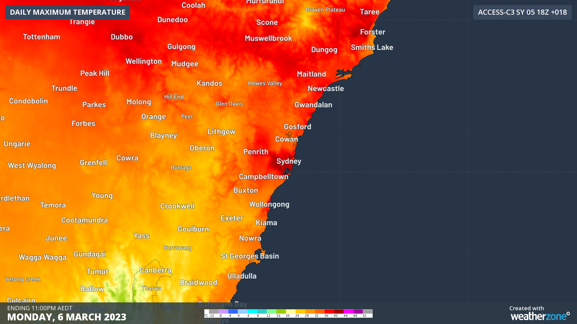
Image: Forecast maximum temperature on Monday, March 6, according to the ACCESS-C model.
At 11am AEDT on Monday, temperatures had already reached 34ºC in western Sydney, 33ºC at the airport and just over 31ºC in the city. This wasn’t far off the state’s highest temperature at this point in the morning, which was 35.8ºC at Bourke.
Temperatures will continue to climb as the day wears on and should reach around 38ºC in Sydney city and possibly close to 40ºC in some suburbs.
This would be the city’s first 38ºC day since November 29, 2020, meaning it will have been 827 days since Sydney last got this hot. The last time Sydney was this warm this late in autumn was 2018.
Monday’s heat will also linger well into the night in Sydney, with temperatures expected to still be up around 30ºC at 9 pm and possibly in the high-twenties at midnight. This evening heat could put pressure on the state’s energy supplies as people get home from work and switch on air conditioners and fans en masse.

Today’s hot and windy weather is also contributing to elevated fire danger ratings across the state. There were already 37 fires burning across the state at 11am AEDT and total fire bans have been declared in seven of the state’s 21 fire districts until midnight tonight.
Tuesday will be another hot day in central and northern NSW, although temperatures will be a few degrees cooler than Monday in Sydney. Cooler southerly winds will reach the city on Wednesday.
Hot, dry and windy weather means increased fire danger across parts of NSW today.
At 11am Monday 6 March there’s 37 bush and grass fires across the state, including one at Watch and Act (Alpha Rd, Tambaroora, Mid-Western LGA). #NSWRFS pic.twitter.com/xZl90NeC70
— NSW RFS (@NSWRFS) March 6, 2023
With the high temperatures, energy demand will be particularly high during the evening. AEMO has issued a forecast LOR 2 (Loss of Reserve Level 2, level 3 is the highest) to occur in NSW between 4:30pm and 7pm, with LOR 1 conditions 30 minutes either side. See this AEMO factsheet for more information on what an LOR means
This demand and lack of reserve could be exacerbated if some cumulus cloud forms this afternoon and evening with some upper instability. This could potentially lower the effectiveness of rooftop solar and cause more people to draw power from the grid. If thunderstorms form, they can basically shut-off rooftop solar production, but also tend to cool the areas they impact so there is a trade-off. Weatherzone rates this a 30% chance of occurring in Sydney today.
To find out more about DTN APAC and our forecasting services, please visit our website or email us at apac.sales@dtn.com.


