
Australia’s southernmost two capital cities both saw their driest month in 11 months this January, with the rain taps turned off in both Hobart and Melbourne.
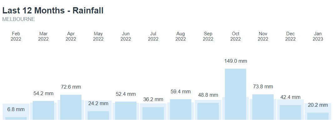
- Melbourne had just 20.2 mm of rain, the lowest since Feb 2022
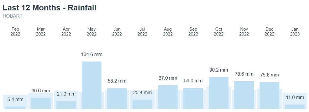
- Hobart registered just 11 mm, also the lowest since Feb 2022
You can see the situation illustrated on the graphs below, which you can find by scrolling down to the bottom of the Melbourne and Hobart forecast pages on our desktop site.
Why the dry January?
Both Melbourne and Hobart have their rainfall reasonably evenly distributed throughout the year. But there is still a slight seasonal difference.
- February is the driest month in both cities, with about two-thirds of the rainfall of the wettest month (October)
- January is the second-driest month in both cities
The reason both cities tend to be drier in summer is that northwest cloudbands are much less common at this time of year. These vast layers of cloud can stretch like a sash all the way across the country from northern WA to Tasmania. Without their influence, neither city has a regular summer moisture source.
Meanwhile, Melbourne’s dry January was not statistically remarkable with just under half the monthly rainfall average, but Hobart’s month was definitely heading into record territory, especially in terms of rain days (as distinct from total rain).
- Rain fell on just four days in Hobart in January, which was the second-lowest on record, and two of those days saw just 0.2 mm.
- The lowest number of rain days for January in Hobart was two days (in 2019).
If you live in either Melbourne and Hobart and have gotten used to heading out without an umbrella, you’d better quite literally take a rain check, as the wet stuff is coming with a cold front a little later this week.
Maximum temperatures will drop to the low 20s or high teens, and while overall rain totals are not expected to be huge, persistent showers can be expected for at least a couple of days from Wednesday onwards in Hobart and Thursday onwards in Melbourne.




