The taps turned on during the opening days of winter in the southwest of WA, after some areas recorded the driest autumn on record.
The rain and thunderstorms over the weekend were triggered by a strong cold front sweeping across the state, interacting with tropical moisture and the warm sea surface temperatures off the WA coastline.
The image below shows a line of thunderstorms marching towards the state’s southwest on Saturday night.
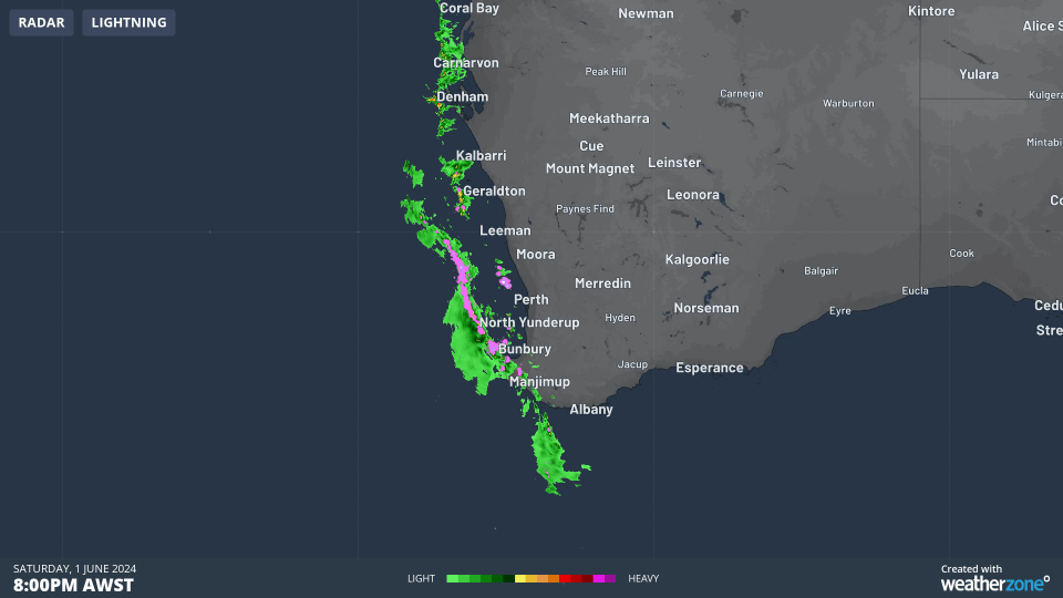
Image: Radar and lightning for the three hours leading up to 11pm AWST on Saturday, June 1.
This line of storms brought Perth a third of their average monthly rainfall, with 42.2mm falling in just 10 and a half hours leading up to 9am on Sunday, June 2. Lancelin to the north of Perth saw 37.8mm fall, while Geraldton picked up 29mm during this event.
The thunderstorms also produced damaging wind gusts on Saturday night, with Rottnest Island recording a 102km/h gust, Busselton Jetty a 91 km/h gust and Armament Jetty 93 km/h gust.
Rain continued to fall in the southwest and Pilbara on Sunday, with Carraba in the Pilbara picking up 50mm in the 24 hours leading up to 9am Monday, June 3.
While rain has continued in the northwest of the state on Monday, the skies will clear up for a couple of days from Tuesday, as a high-pressure system moves in.
Looking ahead, another cold front is setting its sights on WA later this week and is expected to bring significant rainfall to the southwest and interior.
The map below shows the rain forecast for the next week across parts of WA.
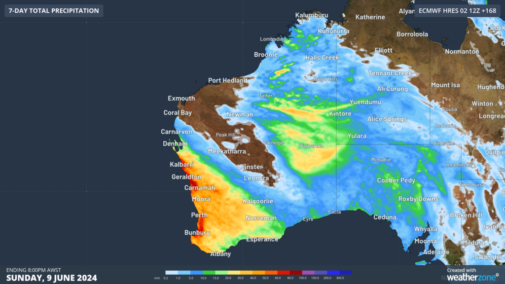
Image: Accumulated rainfall total for the 7 days leading up to 8pm on Sunday, June 9.
The taps turning on in the first week of winter is welcome, after some areas of southwest WA saw the lowest autumn rainfall on record.
The map below shows that while the interior saw above average rainfall and, in some areas, the highest rainfall on record in autumn, the southwest was parched.
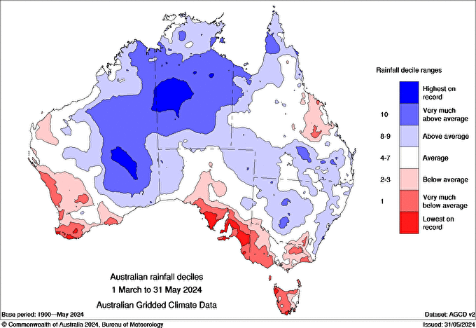
Image: Australian rainfall deciles for autumn 2024. Source: Bureau of Meteorology
Meanwhile the daytime and nighttime temperatures were the highest on record for the west coast of WA.
The map below shows the above average temperatures in the state’s west, while the interior had a cooler autumn.
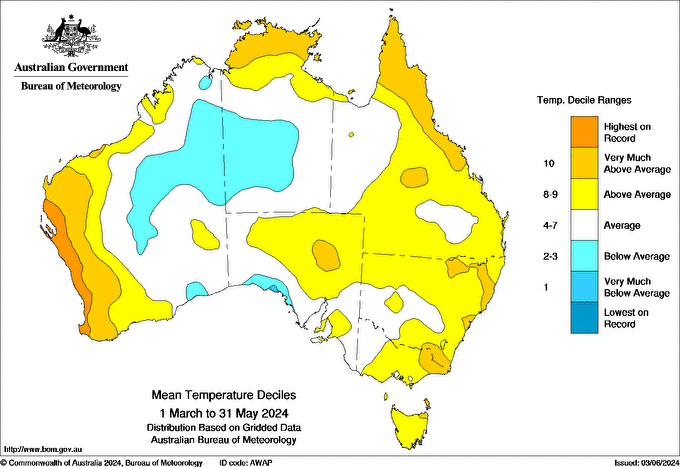
Image: mean temperature deciles for autumn 2024. Source: Bureau of meteorology
The warm and dry autumn in the west was dominated by stubborn high-pressure systems which forced many cold fronts and their associated rain and cooler air further south.
Stormtracker is a severe weather solution that can assist you in observing, in real-time, any storm or event that has the potential to impact your business.
Embedded in DTN APAC’ industry interfaces, the system gives you a time advantage when monitoring conditions developing over your infrastructure and location.
Stormtracker is our Global Information System (GIS) tracking tool, providing multiple weather layers and zoom controls overlaid on a map of your location and infrastructure. You can choose a snapshot or full screen view, depending on your requirements. The maps allow you to monitor all weather, and specifically any systems likely to cause risk for your business. You also have the capacity to observe:
- real time lightning and thunderstorm alerts
- localised lightning strike frequency
- official warnings for storm, cyclone, wind, flood and fire
- sentinel hotspot fires and fire agency current incidents
Stormtracker’s radar imagery updates every 10 minutes, so you are always able to respond rapidly to changing conditions. You can customise alerting to notify you when your staff or infrastructure are under threat. With increased situational awareness, your ability to make informed decisions quickly is optimised.
DTN APAC’ experience and intelligence gives you a clear path through complex situations. Let us assist you, offering actionable insight when extreme weather poses risk to your business. To find out more, please contact us.


