The snow cams at Australia’s mainland ski resorts are looking good for now, but within a week or two, they could be telling a very different story.
Australia has seen no significant snowfalls since the last week of July, and there’s nothing expected over the next few days either, with the weather set to warm up across southeastern Australia in coming days before the chance of a 10 to 20 cm snowfall later next week.
That means that 2024 (the dark blue line below) is starting to look like it could be a mirror image of last winter (light blue line), when the season peak was the earliest on record, with 131 cm at Spencers Creek on July 13, with not much to cheer about thereafter.
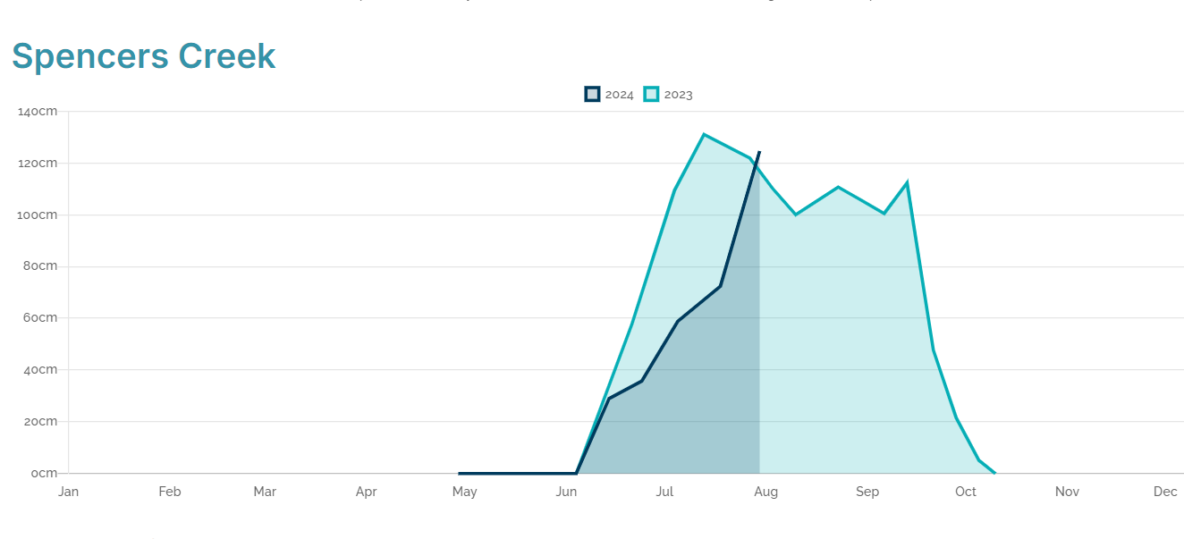
Image: Spencers Creek, at an elevation of around 1830m, is roughly halfway between Perisher and Thredbo. Source: Snowy Hydro.
It is of course too early to make a definitive call that 2024 looks like being a repeat of the disappointing 2023 season, when the second half of winter was marked by unseasonably warm and dry conditions.
The second half of August 2024 could still deliver, and who knows, we could have another 1992 on our hands, when the snow depth (light blue line below) soared from 78 cm on August 6 to 316 cm by September 17.
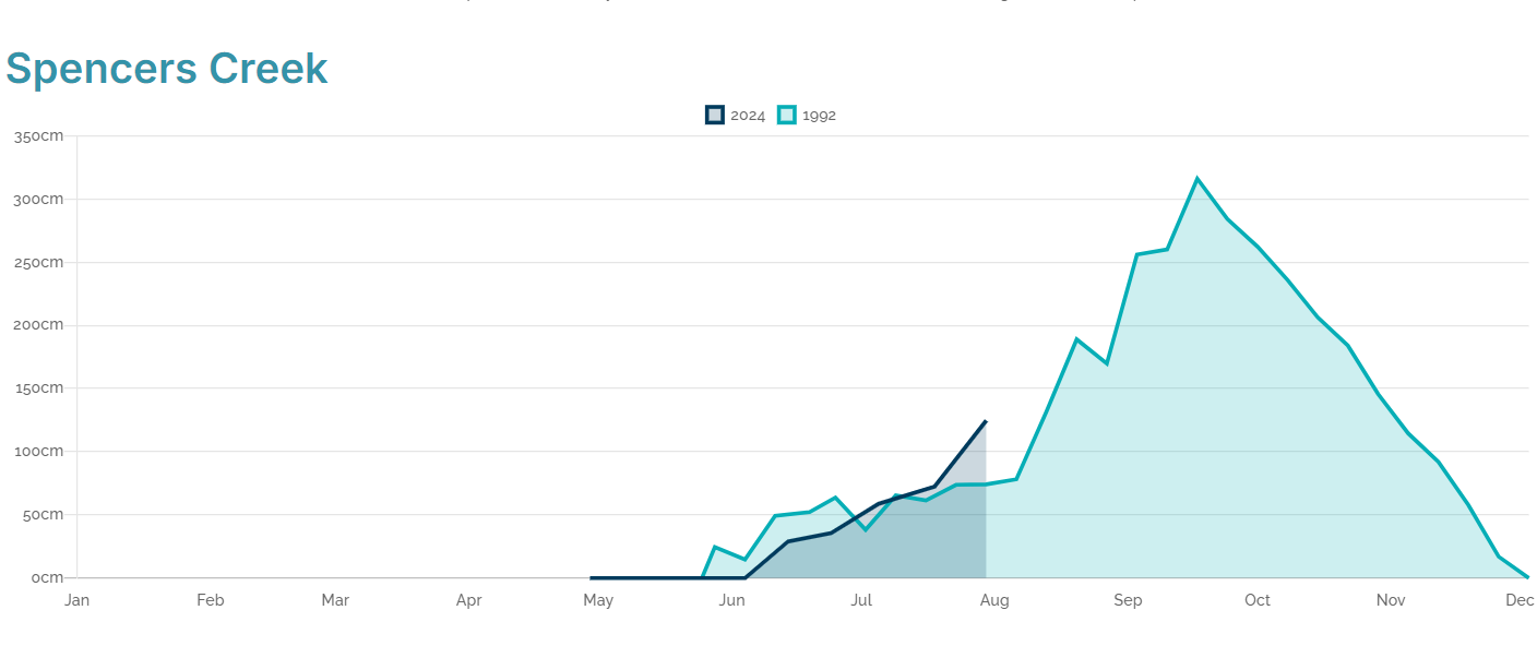
Image: We like how the 1992 snow graph (pale blue) actually looks like a mountain. Source: Snowy Hydro.
When we say that “the second half of August 2024 could still deliver”, that’s more than just a “hopecast”. We’re currently in a negative phase of the Southern Annular Mode (SAM), which means an increased likelihood of Southern Ocean cold fronts pushing northwards to the mid-latitudes.
So where are the big strong cold fronts?
The two key words back there were “increased likelihood“. Snow-bearing systems are not a lock-in. You don’t get a negative SAM and hey presto, here’s your snow! It just means that the band of low pressure systems and associated cold fronts that circulate the globe are further north than usual, so the chance of snow in Australia’s alpine region is higher.
But those fronts still have to peak in the right place.
Another factor to consider at the moment is the Sudden Stratospheric Warming (SSW) event over Antarctica, which we wrote about in mid-July. This event significantly altered the shape of the polar vortex, and directly led to the negative SAM phase.
As Weatherzone meteorologist Joel Pippard wrote at the time, “Given the magnitude of this change, weather in Australia (and the rest of the southern hemisphere) will likely see periods of wetter (trough) and drier (ridge) patterns every two to four weeks during winter and spring.”
Stunning #views at #sunset! ???? pic.twitter.com/IWVoWstwM1
— Hotham (@_hotham) August 7, 2024
If we are indeed in a current pattern of wetter and drier weather lasting two to four weeks, then the snow cams at lower elevations are going to start looking pretty pathetic and patchy by the middle of next week.
But the good news is that there’s every chance that a snowy period will set in later in August through to early or even mid-September. Here’s hoping.
Check the links below for the latest snow reports at Mt Buller, Mt Baw Baw, Mt Hotham and Falls Creek (Vic) and Thredbo, Perisher, Charlotte Pass and Selwyn Snow Resort (NSW). And don’t forget Tasmania’s only commercial ski resort Ben Lomond, which only has one lift open in a typically trying season, but they’re doing their best.
And as ever, our snow page has the latest forecasts, cams and more.
Hydropower
Using Opticast’s nowcasting and forecasting capabilities, you will have long-term outlook covering rainfall and extreme heat events out to 12 months. This can significantly improve your planning as you integrate the data with site-specific hydrological parameters.
With renewables making up more of Australia’s energy mix every year, we want to support your business to make informed critical decisions and improve your overall generation and safety. To find out more visit our contact page or email us at apac.sales@dtn.com.


