A relentless five-day run of oppressive heat is impacting NSW, with some towns in the state expected to see the warmest run of November days in 15 years.
The prolonged period of heat began on Saturday for western Sydney, with Penrith reaching 35.3°C on Saturday and 37°C on Sunday, with the mercury set to soar into the high 30s to low 40s for the next three days.
A blocking high pressure system centred near New Zealand is directing warm northerly winds over eastern NSW in the coming days.
A severe heatwave warning has been issued for parts of the Hunter, western Sydney, the Illawarra and South Coast district of NSW, as a prolonged run of warm days and nights impacts the districts.
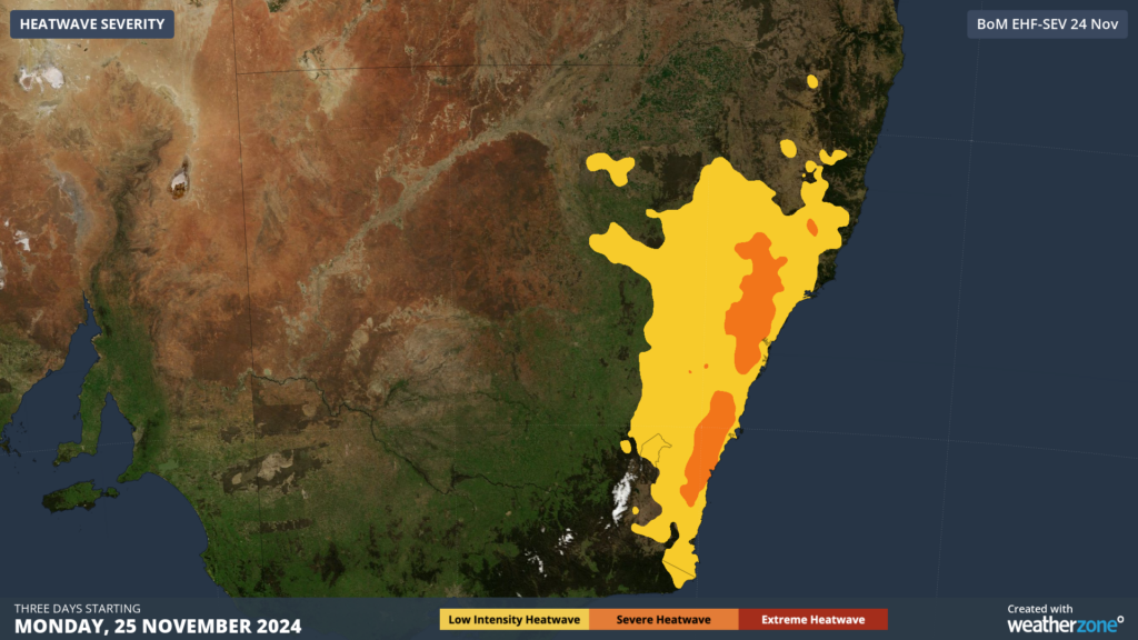
Image: Heatwave severity forecast for the three days from Monday, November 25. Source: BOM
Several towns across NSW will experience the hottest November four-day spell in 15 years beginning on Monday, November 25, including Cowra, Gundagai, Parkes and Gunnedah, while for Richmond in Sydney’s west as well as Maitland and Singleton in the Hunter it’s been 10 years.
Maximum temperatures along coastal Hunter and Sydney districts will reach the low to mid 30s with cooling seabreezes forecast for each of the next three to four days, while the west will soar into the high 30s. Meanwhile the Illawarra, Southern Tablelands and South Coast districts in the warning above should reach the low 30s during this period.
Unfortunately, this heat will be combined with uncomfortably humid conditions, which will make the temperatures feel around 1 to 3°C hotter than the actual temperature.
The hottest day of the run should be Wednesday, ahead of thunderstorm activity and cloud cover forecast on Thursday. The map below shows central areas of NSW that will see the peak of the heat, particularly western Sydney where temperatures could soar into the low 40s.
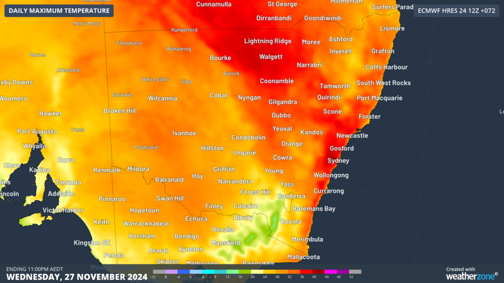
Image: Maximum temperature forecast for Wednesday, November 27
Meanwhile minimum temperatures across eastern NSW will reach the high teens to low 20s during the next 5 to 7 days, with Sydney’s temperature forecast to only drop to 23°C early Thursday morning.
There is relief in sight with temperatures forecast to drop into the low to mid 20s across NSW on Friday and into the weekend as an upper-level low pressure system generates cloud, rain and thunderstorm activity across the state. For detailed forecasts on the heat and humidity please visit our website or email us at sales.apac@dtn.com.
Title image credit: iStock / SCM Jeans


