Prosper in a dynamic world
Search

Severe heatwave about to hit Perth


Australia’s west will be gripped by a severe to extreme heatwave during the remainder of this week, with temperatures set to exceed 40ºC in Perth and reach close to 50ºC in the Gascoyne.

A stubborn ridge of high pressure located to the south of Australia will direct hot and dry air towards the west coast of WA over the next few days.

This weather pattern, which is typical at this time of year, will cause a prolonged spell of very warm days and nights over a broad area of WA. The persistence of this heat will qualify as a severe to extreme heatwave over much of WA’s west coast and adjacent inland, including Perth.

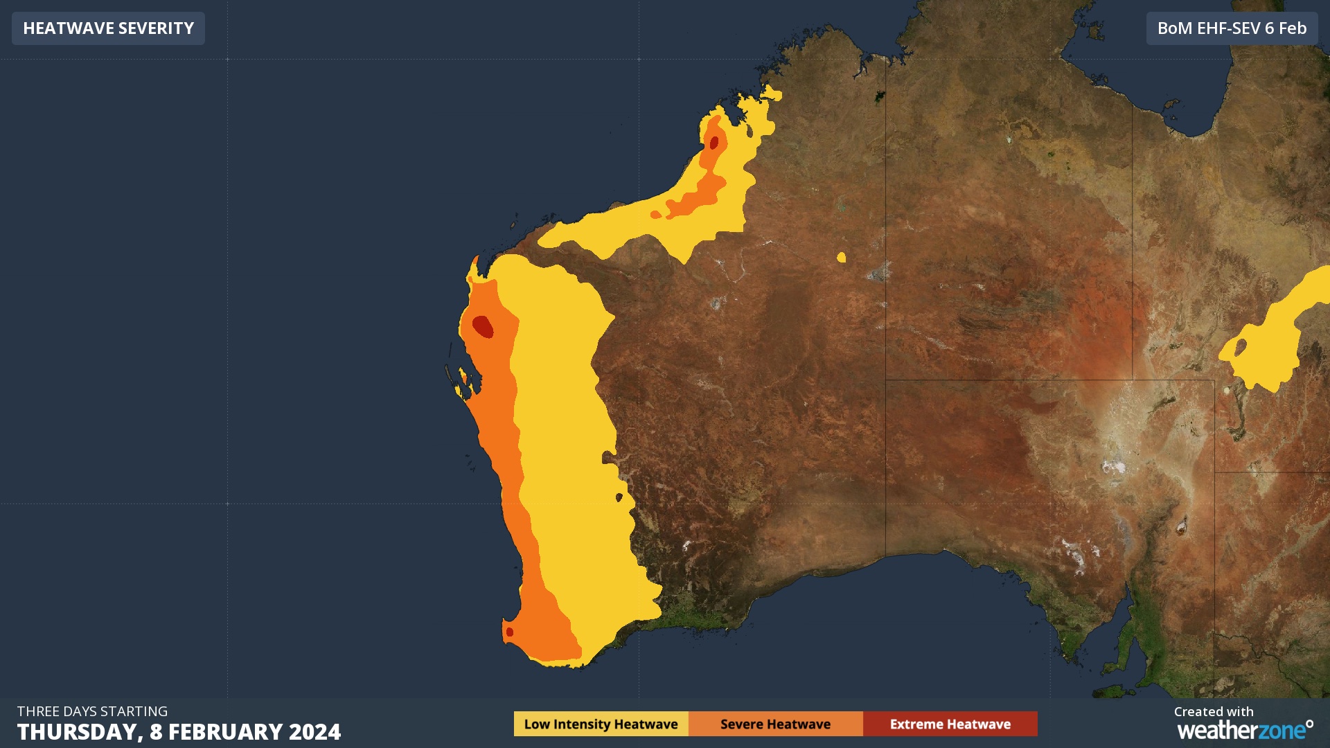
Image: Heatwave forecast for the three days starting on Thursday, February 8.

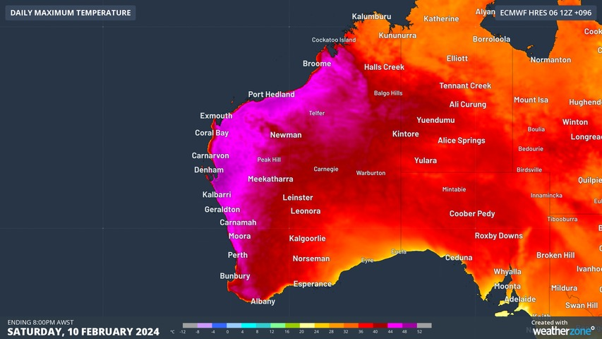
Daytime maximum temperatures in Perth are forecast to reach at least 36ºC from today until at least next Tuesday, with Thursday to Friday likely to see maximums around 39 to 41ºC. Overnight minimum temperatures will also be very warm in the city, possibly only dropping to the low to mid-twenties on most nights during the coming week.

Further north, temperatures could reach the high forties in the Gascoyne region this weekend or early next week. According to the Bureau of Meteorology, Gascoyne Junction is forecast to reach around 48ºC between this coming Sunday and Tuesday, which is not far off its record of 48.8ºC.

If sea breezes fail to keep this intense heat away from Carnarvon, its record of 47.8ºC could also be under threat.

Image: Forecast maximum temperature on Saturday, February 10, according to the ECMWF-HRES model.

While WA is prone to extreme heat at this time of year, prolonged periods of hot weather like this one can have adverse effects on health and the environment. For more information on our energy and extreme heat forecasts, please contact us at apac.sales@dtn.com.

Latest news

Satisfy your weather obsession with these news headlines from around the nation, and the world.

Springtime temperature see-saw threatens NSW with low energy reserves

Two bursts of heat will impact Sydney and NSW in the coming week, driving high energy demand and a forecast Lack of Reserve Level 2 (LOR2) issued by AEMO. Bursts of springtime heat moving east The DTN forecast for Sydney below, generated by our professional team of weather risk analysts, shows two spikes in heat […]

US Climate Prediction Center declares La Niña – what this means for Australian industries?

A La Niña advisory has been issued by the US Climate Prediction Center (CPC), indicating that La Niña conditions have emerged in the tropical Pacific Ocean and are expected to continue for the coming months. What is La Niña? La Niña is one of three phases of the El Niño-Southern Oscillation (ENSO), a coupled ocean-atmosphere […]

Severe thunderstorms, dry lightning and damaging winds spark fires over NSW

Fires were triggered in central NSW by dry lightning on Wednesday as high-based severe thunderstorms tracked over the region which also produced damaging winds. The satellite loop below shows a cloudband moving over NSW on Wednesday afternoon and evening. Clear skies through the earlier part of the day allowed ample surface heating, helping fuel and […]

Rain remains elusive for many Australian agricultural and forestry industries despite expectations of a wet spring

Australian agricultural, forestry and fire emergency agencies and industries that were hoping for a wetter than average spring have been left disappointed by a lacklustre start to the season, despite the emergence of a strong negative Indian Ocean Dipole in recent weeks. Official rainfall outlooks at the end of August were pointing to a good […]