
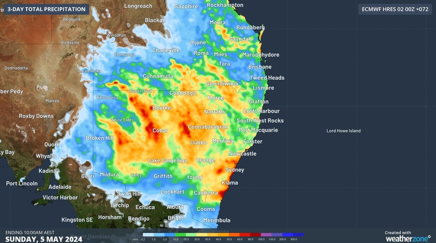
A three-day soaking has begun in NSW, with rain and thunderstorms expected to spread across most of the state over the next 72 hours.
An upper-level cut-off low will pass over NSW from west to east between Friday and Sunday. As this upper low crosses NSW, it will interact with moisture-laden air to produce widespread rain and thunderstorms across the state.
Video: 500 hPa temperature and height from the ECMWF-HRES model, showing the upper-level low passing over NSW between Friday and Sunday.
Storms began to develop near the NSW-SA border on Thursday and became more widespread in far western NSW through Thursday night into Friday morning, in response to the upper-level low. There were also showers along the coast due to a sustained feed of moisture-laden onshore winds.
Some of the notable rainfall totals during the 24 hours ending at 9am on Friday included:
- 46 mm at Greenwell Point
- 39 mm at Currarong
- 28 mm at Evans Head and Manly
- 23 mm at Owen Downs
- 20 mm at Borrona Downs, its heaviest rain in three months
- 13 mm at Fowlers Gap, close to one month’s rain at this time of year
Rain and storms will continue to spread towards the east on Friday and over the weekend, affecting parts of every district in NSW, the ACT and parts of southern and central Qld.
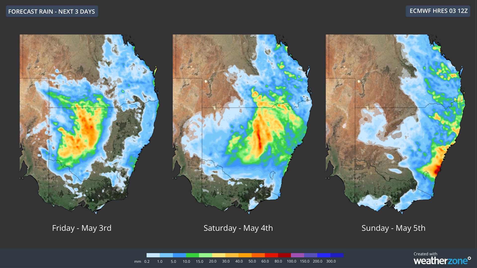
Image: Forecast daily rainfall between Friday and Sunday, according to the ECMWF-HRES model.
The maps above show the predicted accumulated rain over the next three days. Most of the heaviest falls will initially occur over western and central inland NSW, before increasing along the coast from Sunday.
Widespread falls of 20 to 40 mm are likely in western, central and northern NSW and parts of southern and central Qld between Friday and Sunday, with pockets of heavier rain. Some places along the NSW coast could see more than 100 mm by early next week, most likely around the Sydney and Illawarra regions.
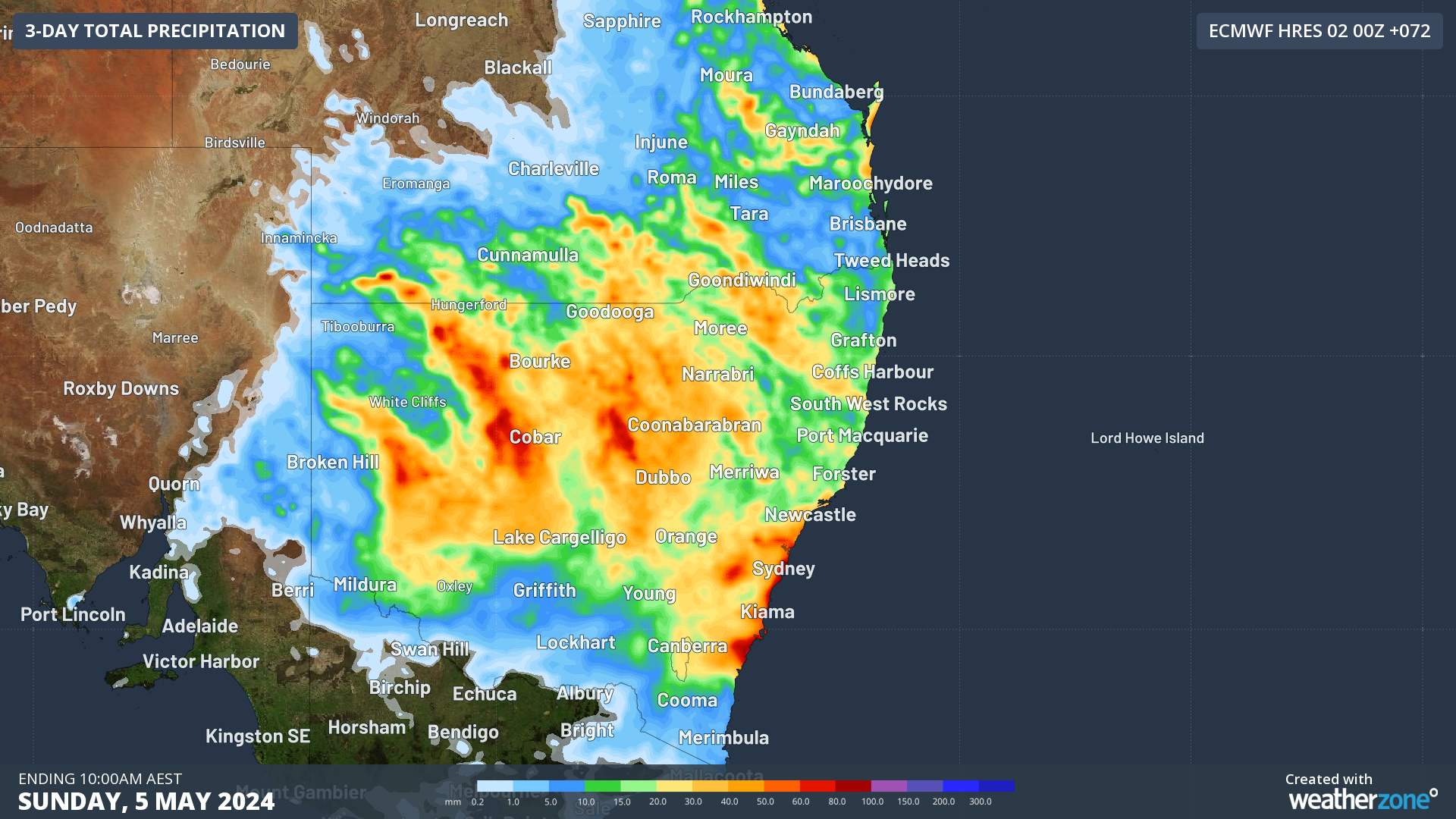
Image: Forecast accumulated rain between Friday and Sunday, according to the ECMWF-HRES model.
Drier weather will return to most of western NSW by the start of next week, although rain will continue along the coast and adjacent ranges into the first half of next week.
This system has the potential to cause severe thunderstorms and flooding, so be sure to stay up to date with the latest warnings in your area.
Stormtracker is a severe weather solution that can assist you in observing, in real-time, any storm or event that has the potential to impact your business. Embedded in DTN APAC’ industry interfaces, the system gives you a time advantage when monitoring conditions developing over your infrastructure and location.
Stormtracker is our Global Information System (GIS) tracking tool, providing multiple weather layers and zoom controls overlaid on a map of your location and infrastructure. You can choose a snapshot or full screen view, depending on your requirements. The maps allow you to monitor all weather, and specifically any systems likely to cause risk for your business. You also have the capacity to observe:
- real time lightning and thunderstorm alerts
- localised lightning strike frequency
- official warnings for storm, cyclone, wind, flood and fire
- sentinel hotspot fires and fire agency current incidents
Stormtracker’s radar imagery updates every 10 minutes, so you are always able to respond rapidly to changing conditions. You can customise alerting to notify you when your staff or infrastructure are under threat. With increased situational awareness, your ability to make informed decisions quickly is optimised.
DTN APAC’ experience and intelligence gives you a clear path through complex situations. Let us assist you, offering actionable insight when extreme weather poses risk to your business. For more information, please contact us at apac.sales@dtn.com.




