
Yet another cold front will bring renewed potential for moderate flooding in Tas and damaging winds, high fire danger and well above average temperatures to southeastern states in the next 48 hours.
The satellite image below shows the cold front and associated rain and cloud approaching SA, Vic and Tas on Friday morning.
Image: Himawari-9 satellite image at 10am on Friday, September 6.
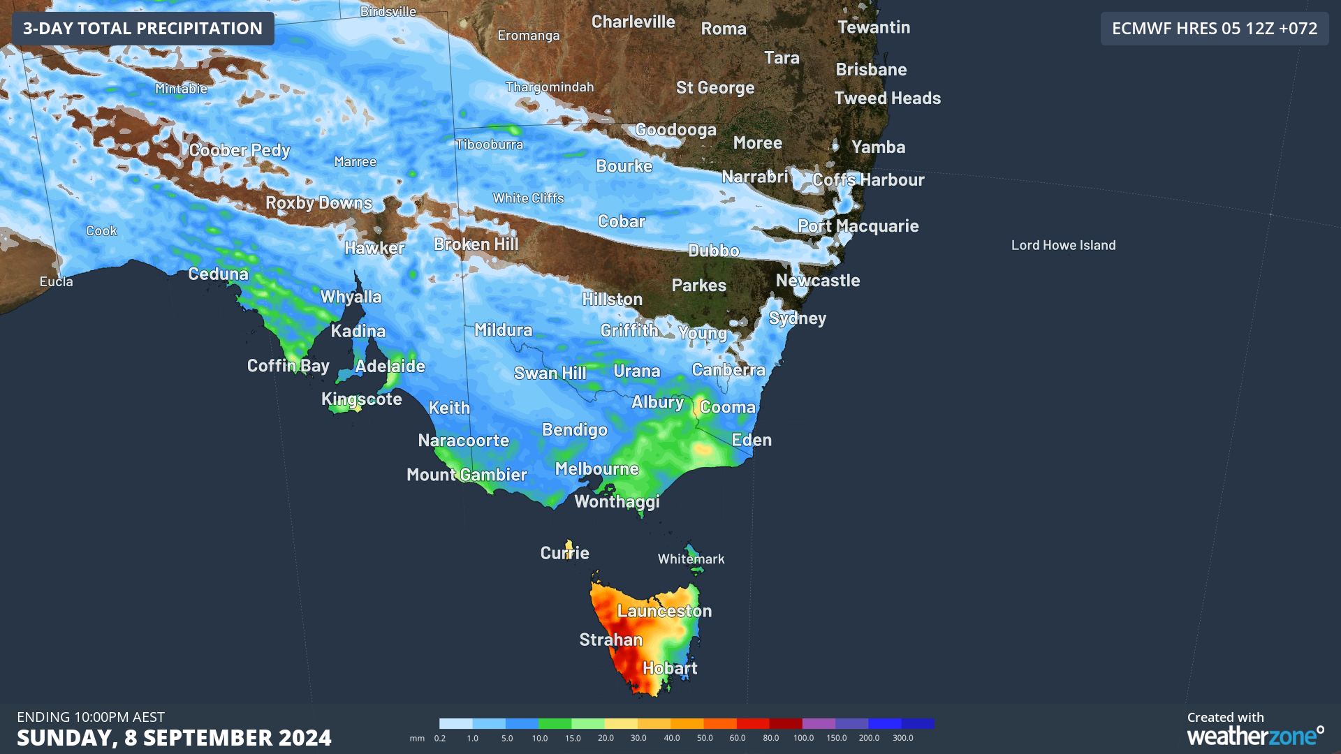
This cold front, along with a couple of others that will march across the south of the continent on the weekend, will bring rain to parts of the southeast in the next 72 hours.
While this rain will not be as heavy as what Tas experienced during the beginning of this week, western and northern parts of the state should pick up another 30 to 60mm, with isolated falls between 60 to 90mm. Snow will fall above 800 metres on Friday and Saturday, before the snow level rises to 1000 metres on Sunday.
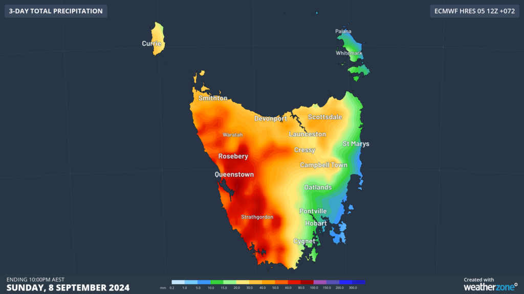
Image: Accumulated rain for the three days leading up to 10pm on Sunday, September 8, according to ECMWF
This rain is falling over catchments which had already become saturated from heavy rainfall earlier this week, leading to renewed potential for riverine flooding.
As of 10:30am on Friday, September 6, a moderate flood warning is current for the Macquarie River and North Esk River from Friday afternoon or evening. Minor flood warnings were current for the Mersey River, Meander River, South Esk River and River Derwent.
Meanwhile, another bout of damaging north to northwesterly winds are impacting the southeast on Friday morning:
- Gelantipy in Vic recorded a 100km/h wind gust at 8am
- Mount Hotham, Vic, saw a 100km/h wind gust at 1:46am
- Mount Buller, Vic, saw a 98km/h wind gust at 3:32am
- Scotts Peak Dam, Tas, observed a 96.3km/h wind gust at 7:37am
- Tasman Island, Tas, recorded a 117m/h wind gust at 7:30am
- Low Rocky Point, Tas, recorded a 106km/h gust at 6:48am
- Thredbo Top Station, NSW, saw 107 km/h mean winds at 2:00 am and a wind gust of 126km/h at 12:35am.
While the damaging winds have eased in Tas, the winds will remain fierce across elevated areas in Vic on Friday. Meanwhile NSW is experiencing damaging winds over the alps which will expand and increase across southeastern Australia during Friday morning. The map below shows the wind gust forecast on Friday afternoon.
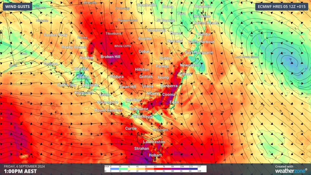
Image: Instantaneous wind gust forecast for 1pm on Friday, September 6 according to ECMWF
In Vic, winds should ease in the west during the late morning, then in central and eastern parts of the state in the evening, while NSW could see damaging winds linger until late Friday evening.
The cold front is also causing a contrasting airmass ahead and behind the front, with parts of southeastern Australia experiencing temperatures around 10°C above the September average, with a cool airmass rapidly approaching southern states.
The map below shows the warm airmass ahead of the front and the cool airmass approaching Tas on Friday afternoon.
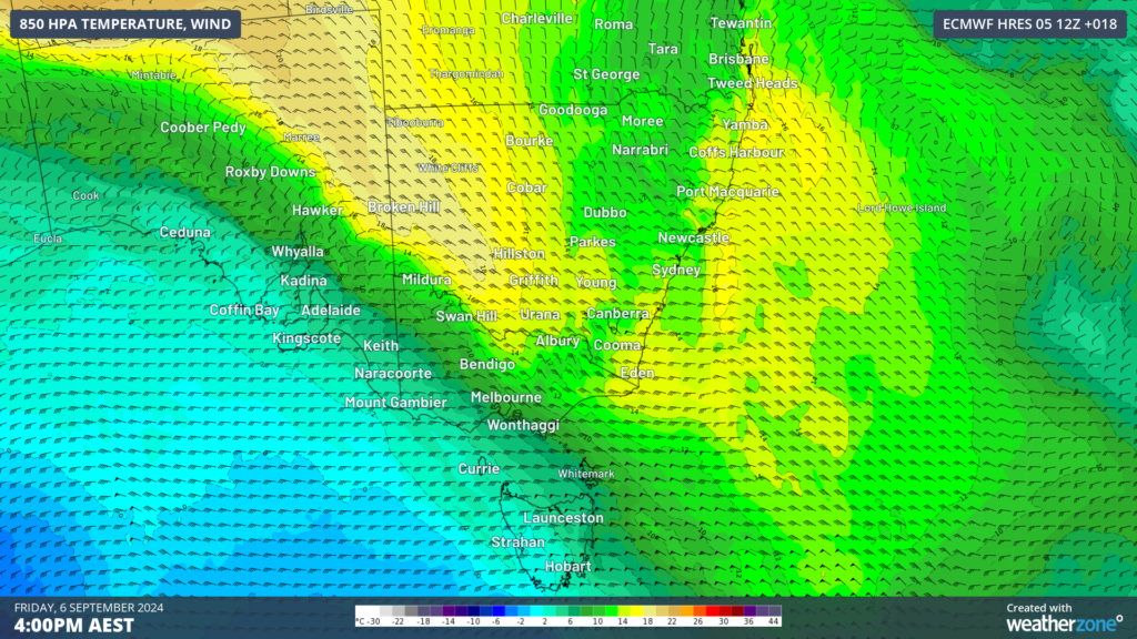
Image: 850 hPa temperature forecast for 4pm on Friday, September 6 according to ECMWF.
The map below shows the maximum temperature forecast on Friday with warm conditions forecast ahead of this front. Sydney is expecting 30°C on Friday, dropping to 24°C on Saturday behind the southerly change. Meanwhile Melbourne is forecast to reach 24°C on Friday, before the temperature plummets to 18 to 19°C on the weekend
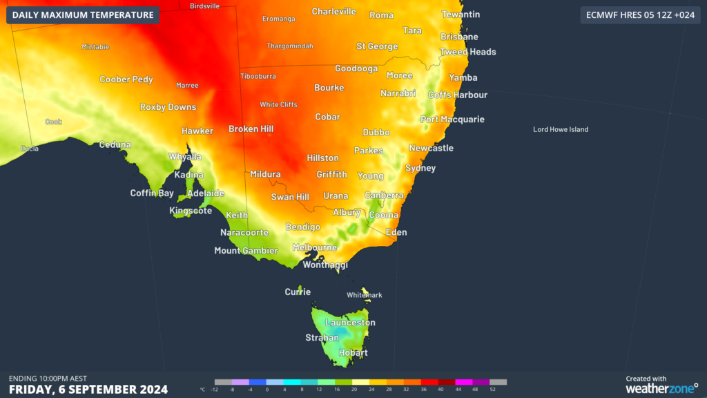
Image: Maximum temperature forecast on Friday, September 6, according to ECMWF
The warm, windy and dry conditions are elevating fire danger across parts of the southeastern states on Friday, with southwest Qld, Sydney, Illawarra and Wentworth forecast to see high fire danger.

Image: Fire danger forecast for Friday, September 6
Looking ahead, a high pressure system will swiftly move into the front’s wake, easing the severe weather for several days. However, there are early signs that we could see another system move across the southeastern states during the middle of next week.
Are you protecting your enterprise from increasingly volatile weather risk?
You can’t control the shifting climate, but you can gain precision insights to optimise your response.
DTN APAC, a DTN company, has been providing weather intelligence and innovative forecasting systems to Australian businesses since 1998.
We have intuitive solutions that serve industries from aviation, mining and energy right through to marine, and everything in between. Rest assured, if we don’t already have a product to address your business’ weather needs, we will work tirelessly to create one.
With our network of global partners, we provide trusted, industry-leading services that can mitigate weather risk, keep your valuable staff and assets safe, and ensure you are operating at peak efficiency. For more information please contact us at apac.sales@dtn.com.




