Prosper in a dynamic world
Search

Melbourne’s warmest day since March

Melbourne is basking is spring-warmth today, ahead of a 10°C temperature drop tomorrow.

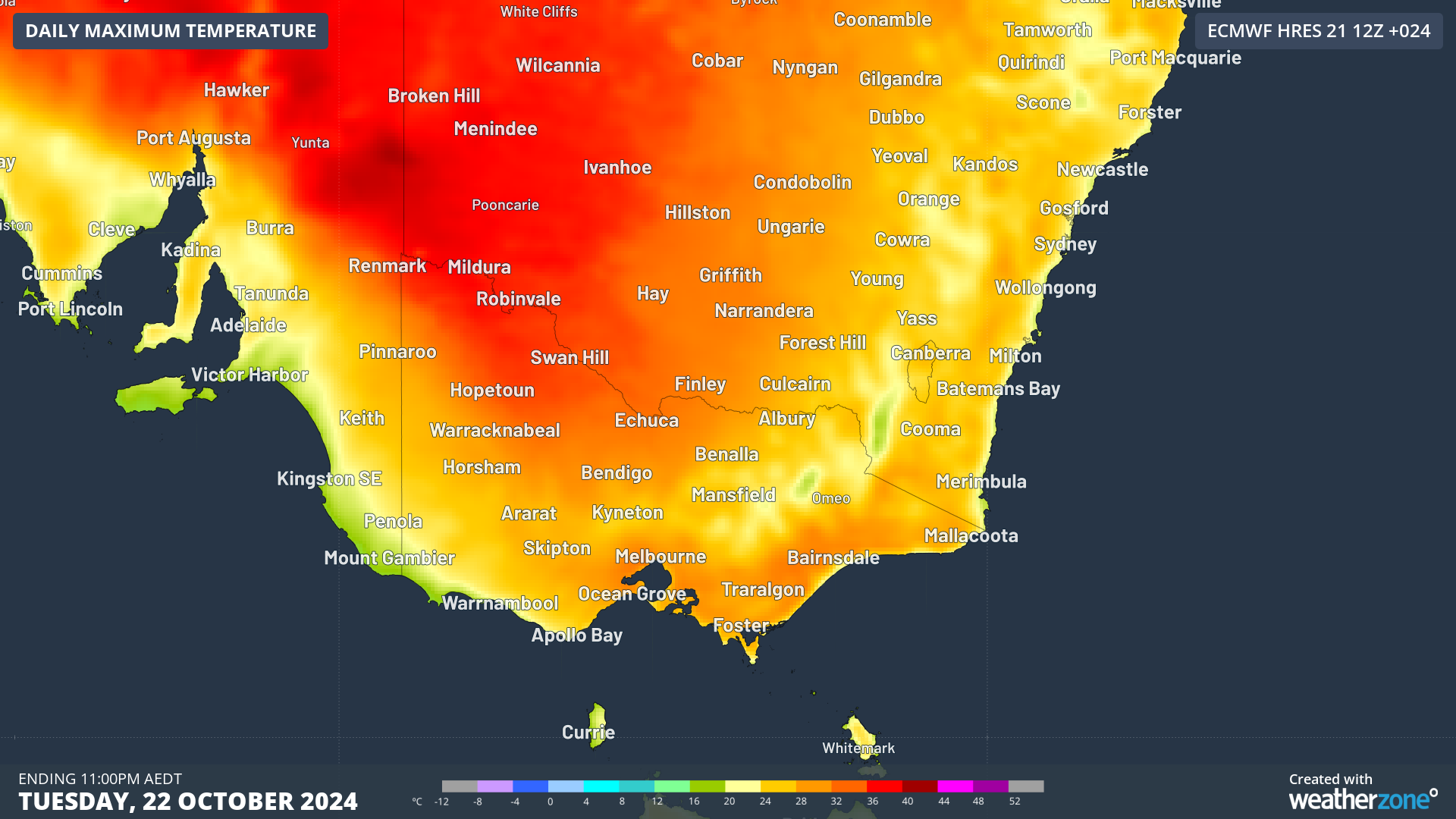
The cities maximum is forecast to be 32°C on Tuesday afternoon, making it Melbourne’s warmest day in seven months and the first time the mercury has reached 30°C since March 18.

Temps will also top 30°C across much of Victoria, with a state high of 36°C expected at Mildura, as a relatively short-lasting tongue of warm air pushes across the state ahead of an approaching cold front.

A southerly change is forecast to reach Melbourne around 4 to 6pm local tonight, bringing some relief to the city in the evening.

There’s not a whole lot of bite to that front. As Wednesday’s synoptic chart shows, the front will barely clip southern Victoria – although it will score a direct hit on Tasmania where a little midweek snow can be expected at the highest elevations.

But winds will still swing around to a southerly aspect and push much cooler air onto the mainland, especially later in the working week.

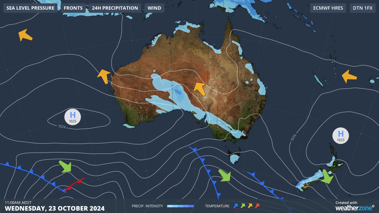
Melbourne maximums will dip to 21°C on Wednesday as a few mostly light showers sweep through, then to a much cooler 16°C and 17°C on Thursday and Friday respectively.

Weatherzone Business has grown to become the outright leader within the Australian energy market, serving wind, solar, hydro, trading, utilities and network companies.

You can’t control the weather, but you can gain precision insights to optimise your response. What lights us up is providing your energy business with tailored weather information to reduce your risk and keep you moving ahead of the curve. 

Our services cover all aspects – from wind and solar generation to demand forecasts, wholesale markets to retail so, no matter where your company sits, we have solutions for you. We have worked closely with market participants to create products that meet the evolving needs of the sector, aiming to increase safety and profitability for our customers. 

Benefit from the timely delivery of accurate weather information, allowing informed and effective decision-making. To find out more visit our contact page or email us at apac.sales@dtn.com.

Latest news

Satisfy your weather obsession with these news headlines from around the nation, and the world.

Rapid El Niño signal accelerating risk for Australian businesses

El Niño–favourable conditions are gathering pace across the tropical Pacific, with key ocean indicators approaching threshold levels and early atmospheric responses emerging.  While uncertainty remains around final El Niño strength, historical analogues show that even weak events can generate widespread impacts, including reduced rainfall, warmer daytime temperatures, increased frost risk, elevated fire danger, reduced tropical cyclone activity, and more. Industries including […]

Australia’s 2025–26 Cyclone Season: Slightly Above Average, Dominated by Severe Systems

Australia has just experienced a highly impactful tropical cyclone season, with more than 60% of systems reaching severe intensity, causing widespread disruption and damage to communities and multiple industries across northern Australia.  The 2025–26 Australian tropical cyclone season officially ran from 1 November 2025 to 30 April 2026. During this six-month period, Australia saw 11 tropical cyclones, with nine […]

What does a ‘super El Niño’ mean for Australia’s businesses?

There are signs that a very strong, or ‘super’ El Niño could develop in the tropical Pacific Ocean later this year. So, what does this mean for Australia’s weather during the second half of 2026? El Niño on the horizon The tropical Pacific Ocean is currently in a neutral state, meaning neither El Niño nor […]

How does DTN help businesses monitor bushfire induced pyrocumulonimbus thunderstorms that ignite more fires?

Intense heat from bushfires during elevated fire danger days can trigger fire-induced pyrocumulonimbus thunderstorms that ignite additional fires. In early January 2026, an extreme heatwave sweeping over southeastern Australia brought catastrophic fire danger to Victoria. Intensely hot bush and grass fires spread erratically and quickly in hot, dry and gusty winds, with pyrocumulonimbus generating lightning, […]