
Another burst of heat will impact southeastern Australia in the next 72 hours, with high to extreme fire danger and fierce winds impacting parts of SA, Vic and Tas.
Tuesday night was sweaty in Adelaide, with the temperature failing to drop below 24.2°C overnight, which is nearly 8°C above the February average.
With this warm beginning to the day, the temperature should comfortably reach the mid-thirties in Adelaide on Wednesday. This will be followed by another warm night that will allow the temperature to swiftly climb reach the low thirties again on Thursday, before a cool change arrives in the middle of the day.
Thursday should be Adelaide’s sixth consecutive day over 30°C, before the temperature finally drops to the low 20’s on Friday.
This prolonged run of heat has been caused by a ‘train’ of high pressure systems which have forced cold fronts and the associated cold air further south.
The map below shows the heat spreading into southeastern Australia from WA on Thursday, ahead of a cold front sweeping across the south of the continent.
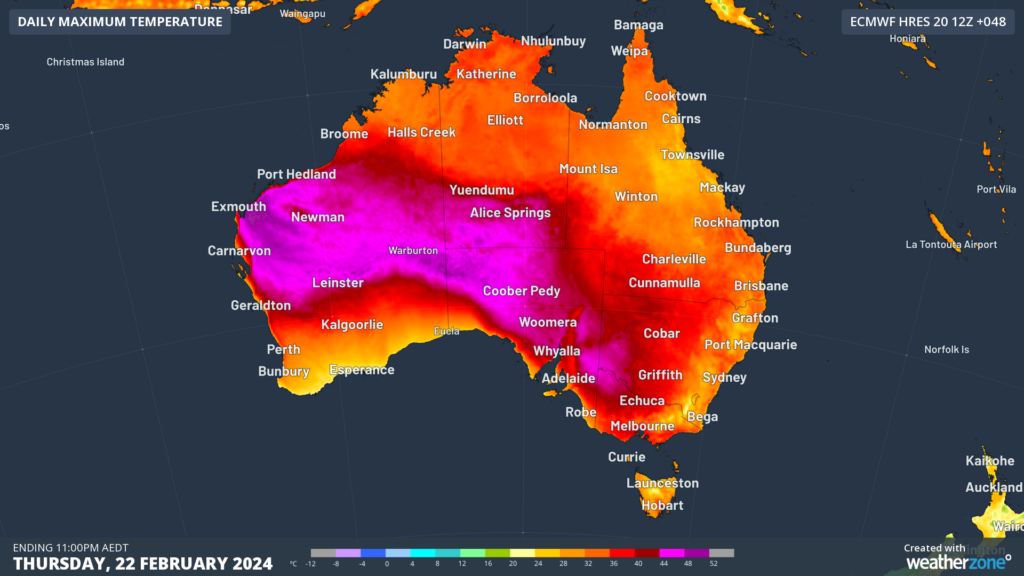
Image: Maximum temperature forecast on Thursday, February 22, according to ECMWF
Melbourne and Hobart’s daytime temperatures will peak on Thursday ahead of this change, with Hobart forecast to top out around 34°C and Melbourne 37°C. Both Melbourne and Hobart’s temperature will be hotter than Darwin and Sydney’s on Thursday.
The heat is being dragged down into the southeastern states by strong and gusty northwesterly winds. The heat combined with the fierce winds are forecast to bring extreme fire danger to parts of southwestern Vic and southeastern SA on Thursday. The map below shows that high fire danger is also forecast for much of Tas on Thursday.
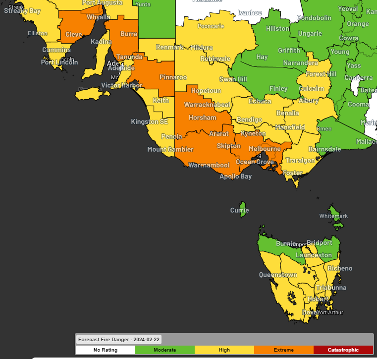
Image: Fire danger forecast for Thursday, February 22 showing extreme fire danger (orange) forecast for parts of VIC and SA.
Damaging northwesterly winds could also impact parts of Vic and Tas on Thursday ahead of the cold front.
As the front sweeps further northeast later in the week, the heat will shift its focus to NSW and Qld on Thursday and Friday.
Sydney’s maximum temperature is set to reach about 35°C on Friday, and the humidity could make the temperature feel 3-4°C hotter than the actual temperature at times.
The increased heat and humidity will also bring an increased risk of thunderstorms over parts of NSW and Vic on Thursday, which may be severe in the Hunter and Mid North Coast districts in NSW. These storms could produce heavy rainfall, damaging winds and large hail.
The risk of thunderstorms will continue into Friday across eastern, central, northeastern parts of the state, including Sydney, near and ahead of a strong southerly change which is expected to arrive in Sydney around 7-9pm. Severe thunderstorms could impact parts of NSW on Friday.
Friday and Saturday should be uncomfortable in Brisbane with the humidity making the temperature feel 5 to 6 degrees hotter than the actual forecast which is the mid 30’s. For more information on our energy forecasts, please contact us at apac.sales@dtn.com.


