A major polar outbreak in southeastern Australia next week will produce a powerful low pressure system that is likely to bring severe weather to several states.
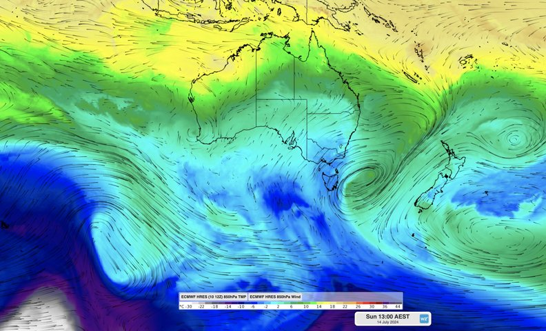
A large pool of cold air that originated over waters near Antarctica will spread across southeastern Australia from this weekend into next week.
This polar air mass will cause temperatures to plummet for several days and nights, likely getting cold enough for decent snowfalls from Tasmania to northern NSW.
In addition to causing a prolonged burst of wintry weather, the polar air mass will also produce a low pressure system over the Tasman Sea from this weekend into next week. This low will strengthen rapidly on the weekend as the polar air mass clashes with a much warmer pool of moisture-laden air over the Tasman Sea.
The strong Tasman Low is likely to cause damaging winds in parts of Tas, Vic and NSW over a four-day period from Saturday to Tuesday. It will also bring heavy rain in parts of Tas and eastern Vic, and large waves along Australia’s southeastern coastline.
Wind
Wind will start to increase over parts of NSW, Vic and Tas on the weekend as the low pressure system deepens to the east of Bass Straight.
Gale force winds with damaging gusts exceeding 90 km/h are likely to impact Tas and eastern Vic on Sunday and Monday, with the potential for periods of storm force winds if the low moves close enough to land.
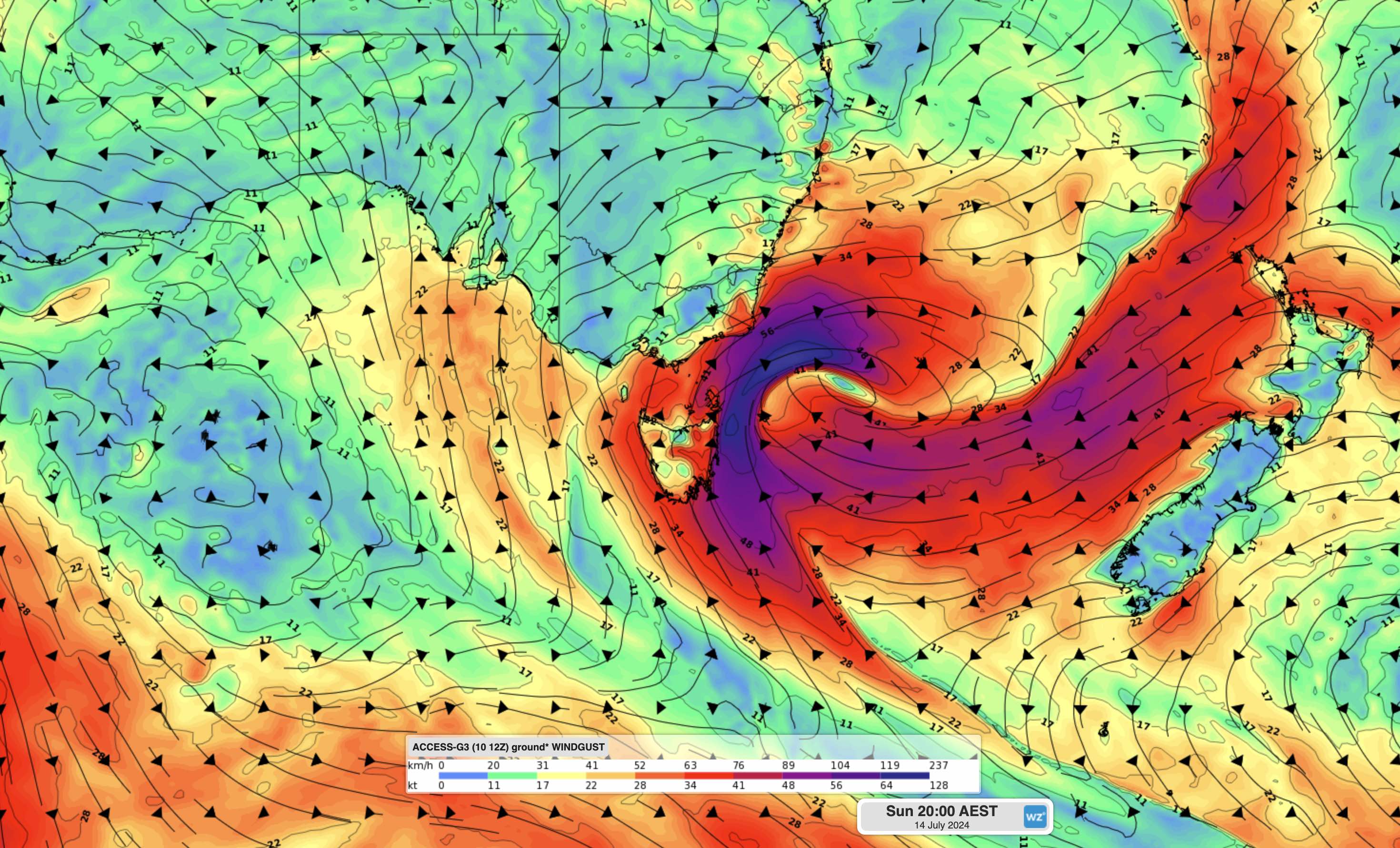
Image: Forecast wind gusts at 8pm AEST on Sunday, July 14, 2024, according to the ACCESS-G model.
Damaging winds will also extend northward across the southern and central NSW ranges and coast on Monday, possibly including the Sydney and Illawarra areas.
The fierce winds that are predicted to hit southeastern Australia from this weekend have the potential to topple trees after a prolonged wet period has led to a soggy landscape. While winds should continue to be strong across eastern Australia on Tuesday, they should ease below damaging strength as the low moves further east over the Tasman Sea.
Rain
Heavy rain should set in across parts of Tas and Vic on the weekend and will likely continue into mid early-to-mid week. At this stage, the largest totals are forecast across southern and eastern parts of Tas and Vic, where winds will be blowing onshore.
Predicting rainfall totals is difficult at this stage because there is some uncertainty regarding the position and strength of the low pressure system. Parts of Tas and Vic should see 30 to 60 mm between Sunday and Wednesday, with potential for more than 100 mm in some areas.
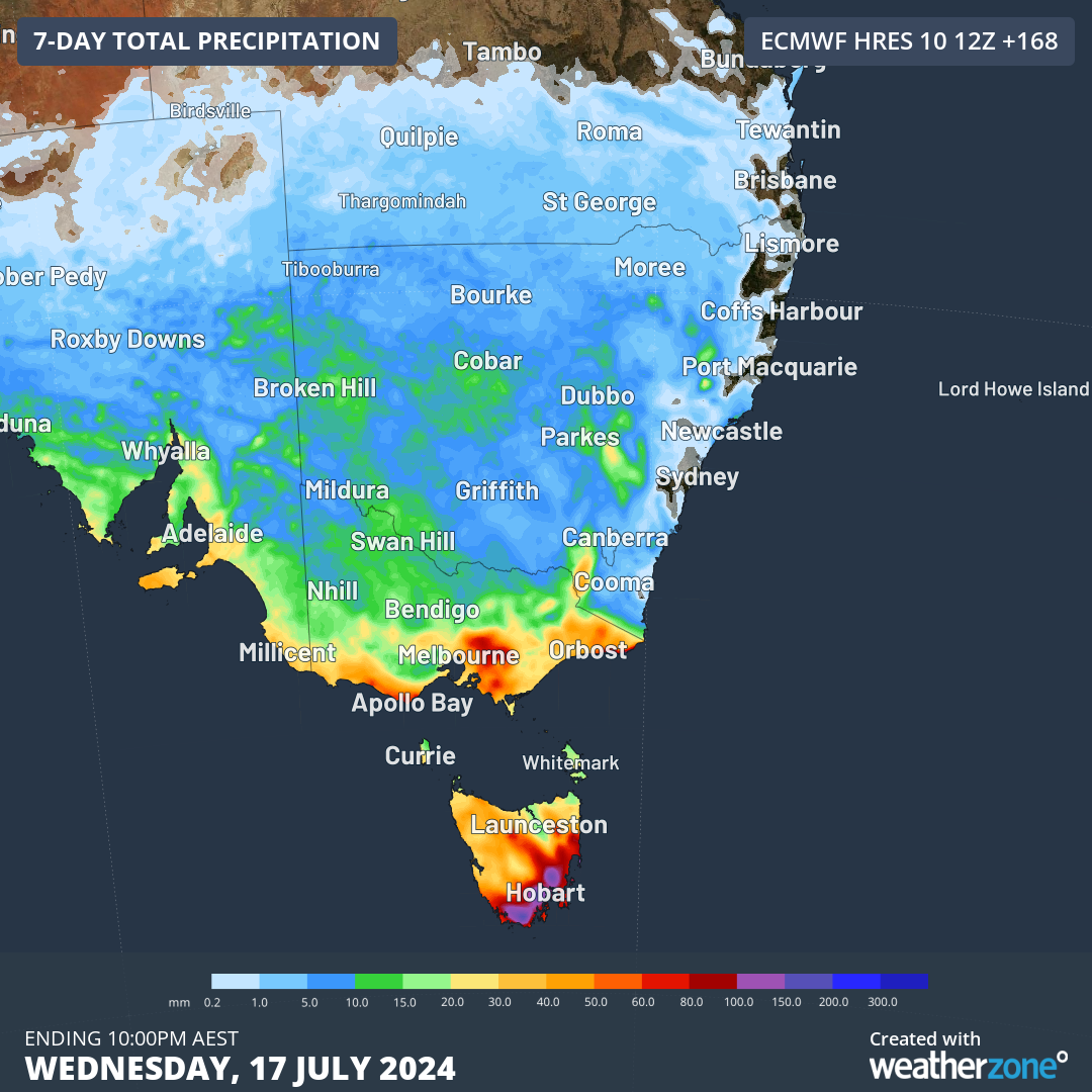
Image: Forecast accumulated rain during the week ending at 10pm AEST on July 17, according to the ECMWF-HRES model.
Swell
The strengthening low pressure system will cause large waves to develop near the coasts of Tas, Vic and NSW from the weekend into early next week. Offshore wave heights could exceed five metres near Tas and four metres off eastern Vic and southern NSW, with dangerous surf likely in all three states.


