
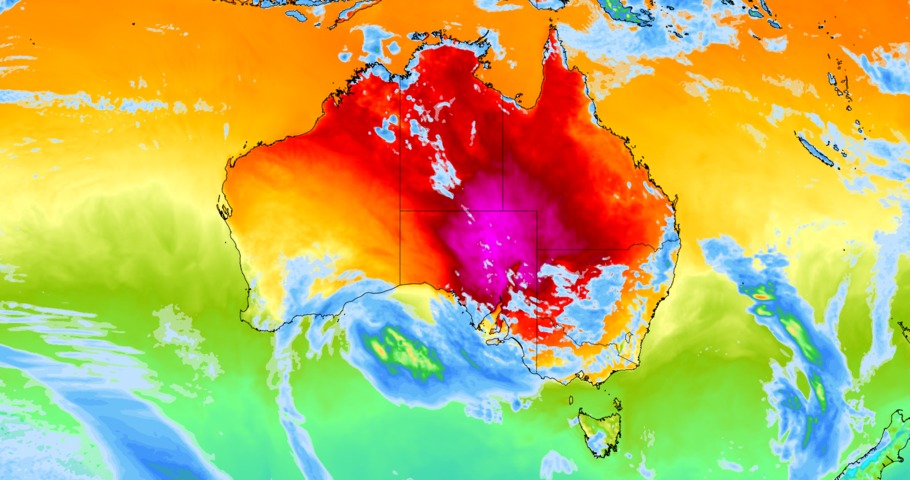
Australia will endure a dynamic mix of extreme weather this week, with intense thunderstorms generating destructive winds in multiple states and record-challenging heat in the outback.
Thunderstorms
Thunderstorms will occur over part of Australia every day this week as a series of troughs and low pressure systems pass over the country, with a particularly nasty outbreak of severe storms set to erupt between Wednesday and Friday.
Thunderstorms were already occurring over parts of southern and eastern Australia on Monday morning. Showers and storms will become more active over the country’s east on Monday afternoon and severe storms could develop over parts of central and southern NSW in the afternoon or evening.
Storms will then continue to develop over a broad area of southeastern Australia on Tuesday and Wednesday, affecting parts of NSW, Vic, SA, southern Qld, and possibly Tas.
Wednesday will also see rain and thunderstorms building over the southern half of WA as a cold front and low pressure system hit the state. Some of these storms are likely to become severe, with damaging to destructive winds, large hail and heavy rain all a risk.
After battering WA on Wednesday, the low pressure system and cold front will drift further east and cause a dangerous outbreak of thunderstorms across parts of SA, NSW, the ACT, Vic, Tas, the NT and Qld on Thursday and Friday. These thunderstorms are likely to cause damaging to destructive winds in multiple states, with large hail and bursts of heavy rain also a risk.
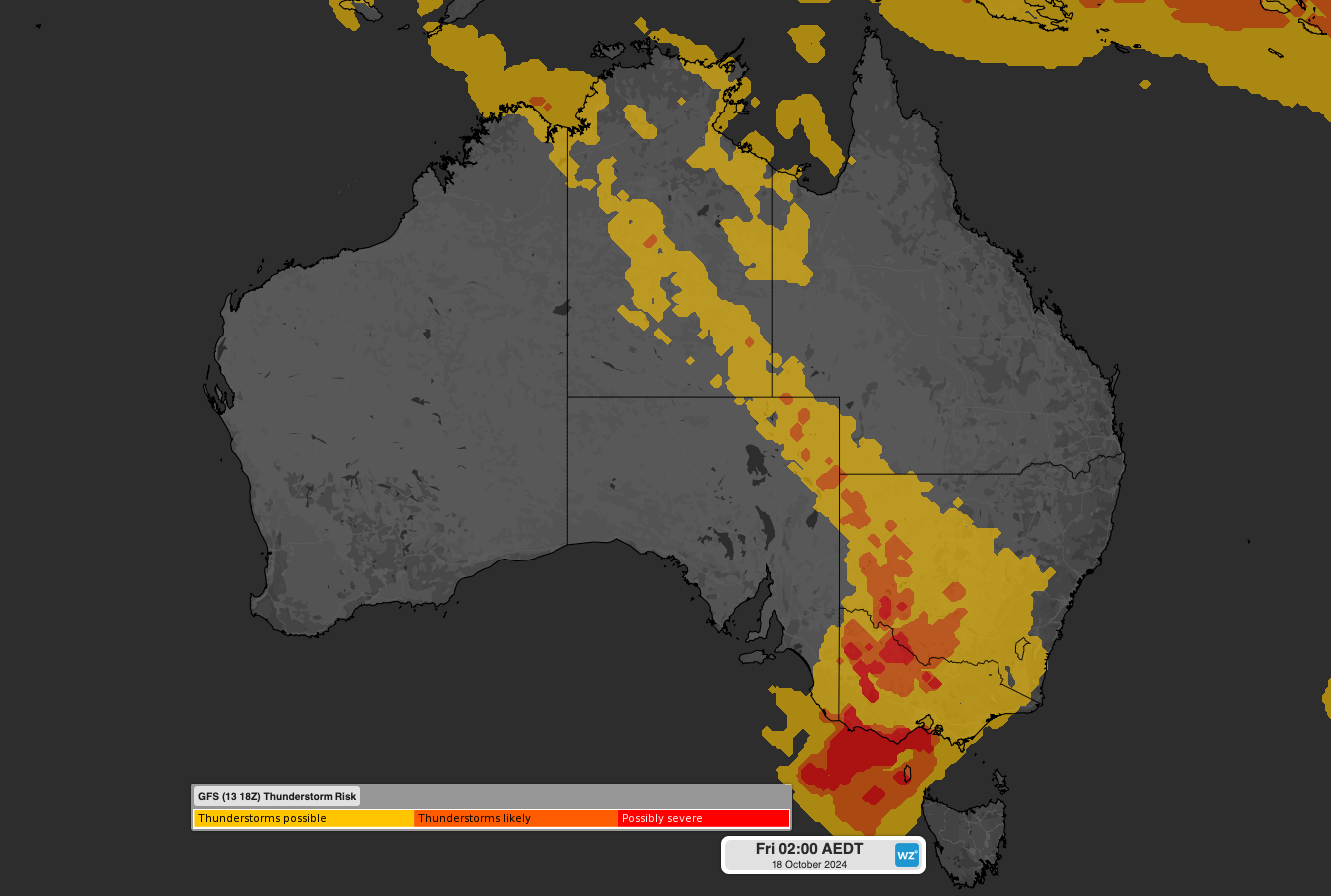
Image: Thunderstorm risk over Australia on Thursday night.
The combination of tropical moisture feeding into a mid-latitude low pressure system and ample atmospheric instability will cause a lot of lightning on Thursday and Friday. Some forecast models suggest that storms will stretch more than 3000 km from the Top End down to Tasmania.
Record-challenging heat
One of the reasons Australia will see so much thunderstorm activity this week is because air masses of contrasting temperatures are set clash above the continent.
A remarkably hot pool of air is expected to drift over central Australia in the middle of the week after being drawn southward ahead of the approaching cold front.
Daytime temperatures in the north of SA could reach the low-to-mid forties on Wednesday and Thursday. Overnight minimum temperatures will also be exceptionally high in parts of central Australia on Wednesday and Thursday nights, with some places possibly staying above 30°C throughout each night. This outback heat could challenge records for this time of year.
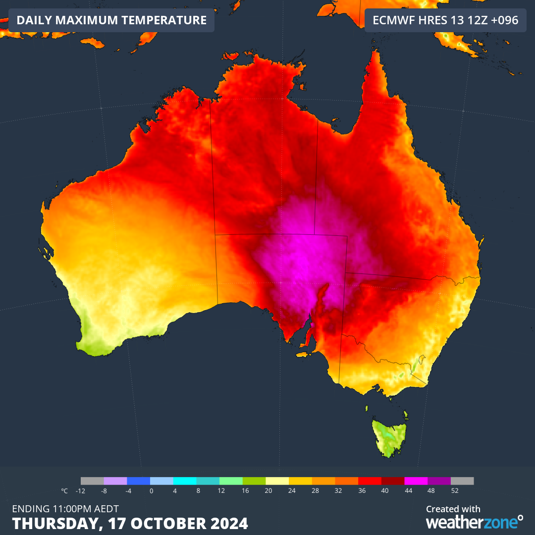
Image: Forecast maximum temperature on Thursday, October 17. 2024, according to the ECMWF-HRES model.
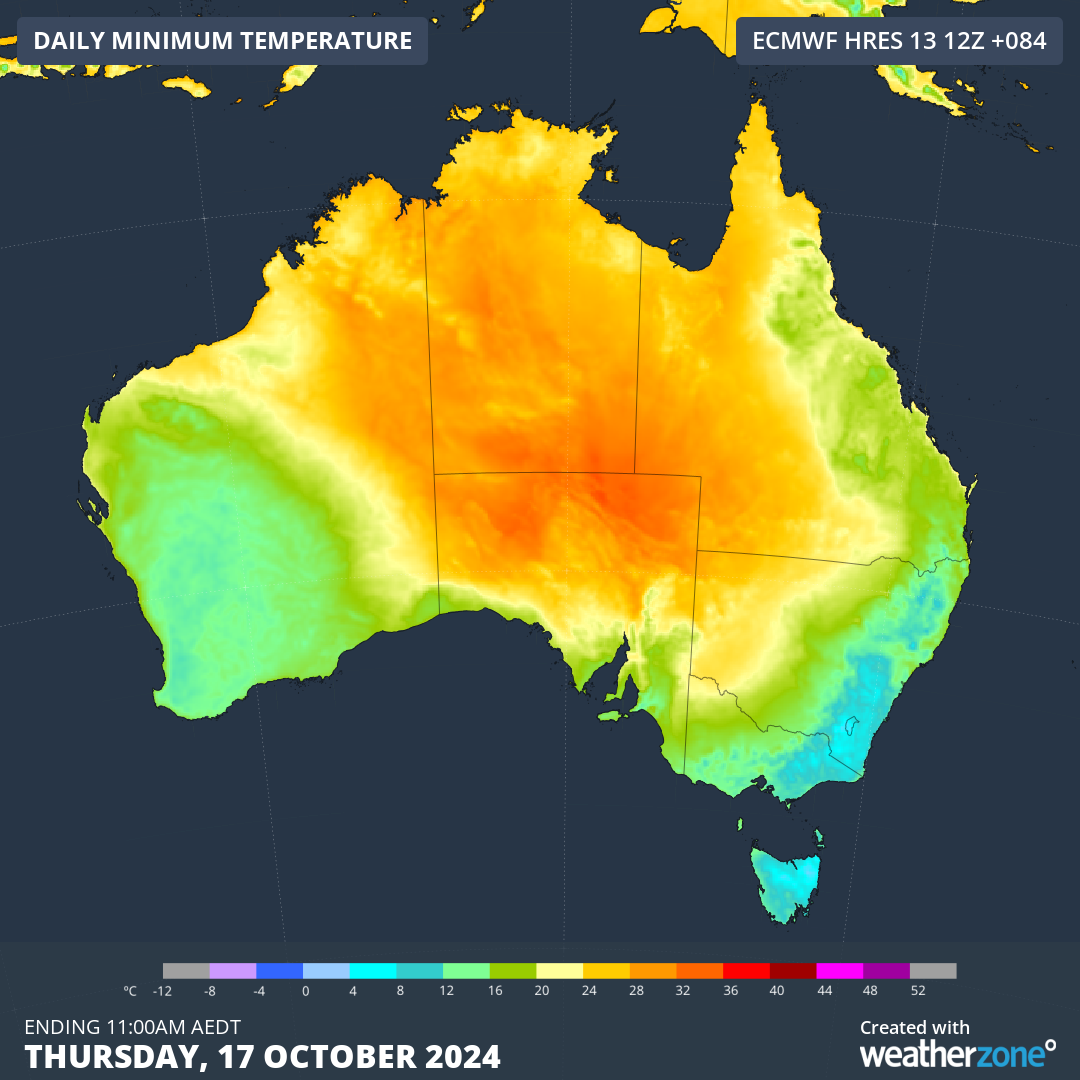
Image: Forecast minimum temperature on Thursday, October 17. 2024, according to the ECMWF-HRES model.
Some models predict that temperatures will reach 43 to 44° over northern SA on Thursday afternoon, which is close to the state’s October maximum temperature record of 45.4°C from 1995.
Models also suggest that minimum temperatures could be near 30°C on Wednesday and Thursday nights in northern SA and southwest Qld. If this happens it would challenge Australia’s highest October minimum temperature record of 29.5°C from 1977.
Spring is always a time of year for volatile weather in Australia and this week will be a perfect example of how turbulent a mid-October week can be.
Stormtracker is a severe weather solution that can assist you in observing, in real-time, any storm or event that has the potential to impact your business.
Embedded in DTN APAC’ industry interfaces, the system gives you a time advantage when monitoring conditions developing over your infrastructure and location.
Stormtracker is our Global Information System (GIS) tracking tool, providing multiple weather layers and zoom controls overlaid on a map of your location and infrastructure. You can choose a snapshot or full screen view, depending on your requirements. The maps allow you to monitor all weather, and specifically any systems likely to cause risk for your business. You also have the capacity to observe:
- real time lightning and thunderstorm alerts
- localised lightning strike frequency
- official warnings for storm, cyclone, wind, flood and fire
- sentinel hotspot fires and fire agency current incidents
Stormtracker’s radar imagery updates every 10 minutes, so you are always able to respond rapidly to changing conditions. You can customise alerting to notify you when your staff or infrastructure are under threat. With increased situational awareness, your ability to make informed decisions quickly is optimised.
DTN APAC’ experience and intelligence gives you a clear path through complex situations. Let us assist you, offering actionable insight when extreme weather poses risk to your business. For more information, please visit our website or email us at apac.sales@dtn.com.




