Prosper in a dynamic world
Search

Cheeky taste of winter for the southeast

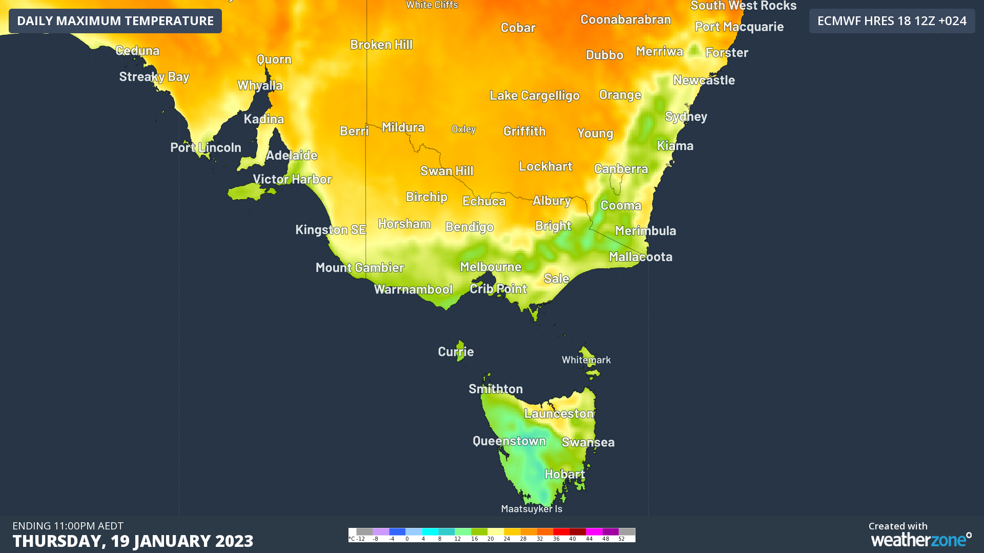
It’s a chilly one in southeast Australia this Thursday, after a couple of days of serious summer heat.

Temperatures plummeted to -1.8°C overnight at Mt Hotham in the Victorian High Country, which was the coldest reading of 2023 to date anywhere in Australia.

As you can see in the image below showing live temps just before 10 am on Thursday, it was still zero up at Mt Hotham after breakfast time, with temps in the teens or much lower right across Victoria, Tasmania, southern NSW and southeastern SA.

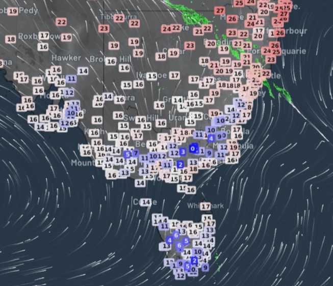
The streamlines (thin white arrows) on the the image above tell you most of what you need to know about the reason for the unseasonable chill. Southerly winds in the wake of a cold front have significantly moderated tempreatures, and the cool fan will stay on for the next few days.

That means that:

  • Melbourne’s maximum should be just 19°C today and in the low-to-mid twenties for the next few days after hitting 37°C twice within the last four days.
  • Sydney is also looking at top temps in the low-to-mid twenties after Wednesday was its first 30-degree day since February 21, 2022.
  • Adelaide topped 35°C five times within six days and exceed 40°C on of those days, but it, too, will avoid temps over 30°C for at least the next two days.
  • When cool weather is about, Canberra always comes to that party, and in addition to a string of days with coolish maximums for mid-summer, the national capital will see a few nights of single-digit minimums.
  • Hobart will also be back to maximums in the low-twenties after toping 30°C in two of the last four days.

Enjoy the cool break if you’re living in the southeast, because there’s no doubt plenty of hot weather still to come.

DTN APAC provides accurate temperature forecasts as far as 14-days in advanced through our Opticast system. To find out more, please email us at apac.sales@dtn.com.

Latest news

Satisfy your weather obsession with these news headlines from around the nation, and the world.

How is DTN APAC equipped to service the offshore wind farm industry?

Wind turbines are usually pictured on rolling hills far from cities and people, but what if they were on rolling swells off the coast of populated areas? Australia’s National Electricity Market (NEM) and WA renewable power network currently harnesses wind power from 115 wind farm facilities and a capacity of 15,617 MW, according to OpenNEM. […]

Quarter million lightning strike and heavy downpours smash southwest WA businesses

The southwestern tip of Western Australia is the latest corner of the country to see exceptionally heavy winter rainfall, with 24-hour totals topping 100mm at some locations, and over 250,000 lightning strikes causing costly shutdown procedures. Storms and heavy downpours pelted much of the South West Land Division on Wednesday as a cold front and […]

East Coast Low brings intense night of wind, rain and surf to NSW businesses

The East Coast Low lashed large parts of the NSW coastline in the 24 hours to Wednesday morning as damaging to destructive winds, intense rainfall and large waves disrupted industries from aviation to ports, and transport to power utilities. The stretch of NSW coastline from the Hunter region to the South Coast has been most […]

East Coast Low deepening near NSW coast disrupting aviation, transport and utility industries

Heavy rain, destructive winds and damaging surf will batter eastern NSW in the coming days following the explosive development of an East Coast Low leading to significant disruptions to transport, aviation and utilities. A coastal trough located off the southeast Queensland and northeast NSW coast rapidly intensified into a low pressure system overnight into Tuesday […]