
A series of strong cold fronts have brought a dangerous mix of damaging to destructive winds, heavy rain, record flooding and huge snowfalls to Tas on the weekend.
The severe weather caused widespread power outages across the state, with thousands of homes and businesses still without power on Monday, with no restoration time announced.
Maatsuyker Island saw a mean wind speed of 163km/h and a gust up to 187km/h on Saturday afternoon, this mean wind speed is equivalent to a category four tropical cyclone. Several wind records were broken on Sunday evening, with Launceston recording a 130km/h gust and King Island 157km/h gust.
Some other destructive wind observations over the weekend and Monday morning were:
- Kunanyi (Mount Wellington) observed a mean wind speed of 137km/h and a gust up to 172km/h on Saturday evening.
- Low Rocky Point recorded a mean wind of 128km/h and a gust up to 165km/h late Saturday afternoon.
- Hartz Mountain observed a 106km/h mean wind and a gust to 163km/h on Saturday evening.
- Mount Read saw a 141km/h wind gust on Sunday evening
- Swan Hill recorded a 124km/h wind gust at 1:26am and again at 8:26am on Monday morning.
The immediate threat of damaging winds has now passed for all but the Tasmanian highlands, however another bout of damaging winds is forecast from early Tuesday morning over elevated parts of the Central Plateau, North West Coast, Central North and Midlands districts.
While the wind threat has temporarily eased, there are several warnings for major flooding across some catchments and rivers in the state, with the west receiving 200 to 300mm of rainfall in the last week.
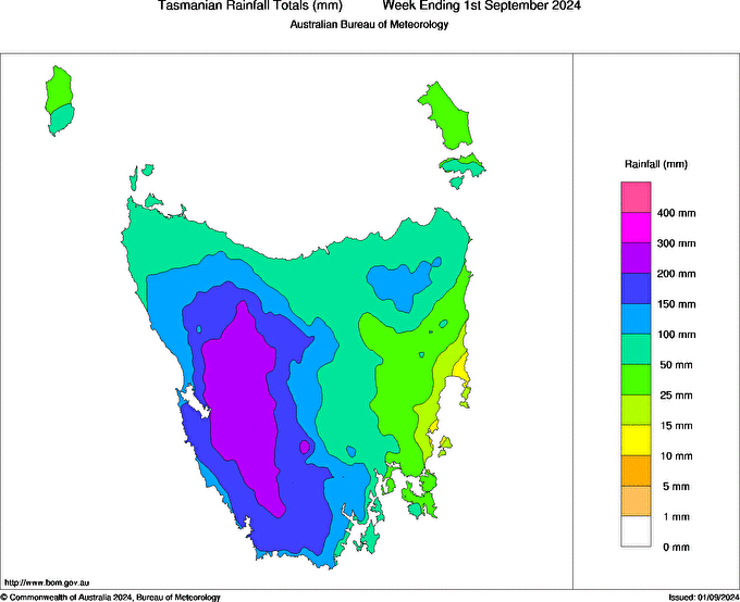
Image: Tasmania rainfall totals for the week ending on Sunday, September 1.
With another 40 to 60mm caught into some western gauges on Sunday, September 1. Large snowfalls have also been reported in Tas, with locals saying there is much as 80cm of snow cover at Mount Mawson, the tiny club-run ski field about 90 minutes to the west of Hobart.
The images below show the snow coverage increased further on Monday as more snow fell overnight, with snow continuing to fall on Monday.
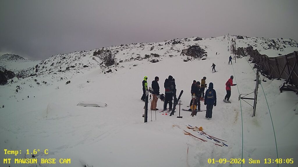
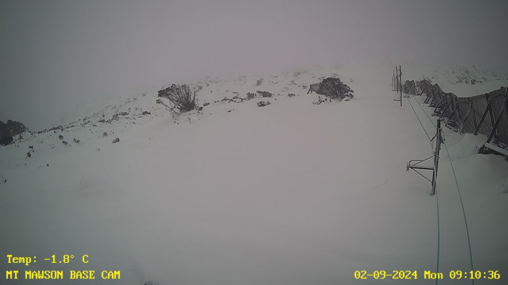
Images: Mount Mawson base camera on Sunday afternoon (top) and Monday morning (bottom). Source: Mount Mawson snow cam
A flood emergency warning was issued on Monday morning for the Derwent River, with people being told to evacuate the Derwent River, Meadowbank to Macquarie Plains and Styx River, Bushy Park to Macquarie Plains and surrounds.
While there is moderate flooding across several other rivers across the state, including the Macquarie River, Meander River, Mersey River, North Esk River, South Esk River.

Image: Flood emergency warning (red), Watch and Act (orange) and flood advice (yellow) as of midday Monday, September 2. Source: TASALERT
Meadowbank Dam in the central highlands region in Tasmania exceeded the Major flood level on Monday morning, possibly causing the dam to spill.

Image: Meadowbank Dam water levels showing the dam has surpassed the major flood level (red) on Monday morning. Source: Bureau of Meteorology
This dam is run by Hydro Tasmania and is used to generate electricity in the Meadowbank run of the river hydroelectric power station. The Bureau of Meteorology is forecasting record levels just below Meadowbank Dam, therefore the River Derwent at Macquarie Plains is likely to peak near the major flood level (6.70 metres) around Monday evening.
Lake Augusta has also seen major flooding and spilling on Sunday and Monday.
Image: Lake Augusta spilling on Sunday, September 1 Source: @uniquetasmania / Instagram
The rain is also still falling as a cold front crosses the region on Monday, with river and dam levels set to rise further in some areas. Yet another 100 to 200mm is forecast in the next 7 days across parts of western Tas, while the east could see 40 to 80mm.
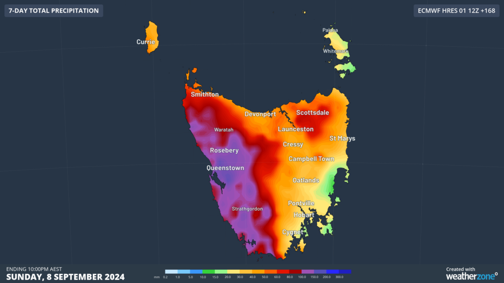
Image: Accumulated weekly rainfall up to 10pm on Sunday, September 8, according to ECMWF
The rain and snow should ease on Tuesday as a high pressure system moves into the fronts wake, however rain will intensify again from Thursday evening as couple of systems approach and pass the state.
While winds should ease later Tuesday, another couple of bursts of damaging winds could impact the state from mid to late this week.
DTN APAC, a DTN company, offers precise weather intelligence and alerting to protect your utilities network when severe weather, floods and fires threaten.
Over 80% of Australian transmission and distribution networks already rely on our proven nowcasting and forecasting out to 15 days. You can rest assured yours is protected by market-leading analysis. With this foresight you can gain lead time to prepare for possible outages, reduce risk and protect your people and profits.
You will never be left in the dark when conditions suddenly worsen. We deliver reliable, up-to-the-minute weather forecasts and analytical tools that give you the power to enhance your operational management and response to weather risk. Our Total Lightning Network is a globally proven solution that accurately identifies and alerts you to lightning strikes within your defined thresholds, supporting the safety of your team.
Your customisable interface has GIS mapping, showing multiple weather layers over your utilities network and offering full situational awareness. You can quickly recognise any threat to your assets in real-time. 24-hour asset monitoring allows you to track lightning, bushfires and other severe weather systems that approach your service territory.
Advanced and actionable analytics allow you to act decisively and improve your planning and outage response strategy.
For more information, please visit our website or email us at apac.sales@dtn.com.


