

Well done, Brisbane. You’ve just shivered your way through your first night of the year below 10 degrees.
The temperature in downtown Brisbane dipped to a chilly 8.2°C overnight, with a reading of 7.2°C at the airport and much colder temps inland, including –0.1°C at Kingaroy, which was the Sunshine Coast hinterland town’s first subzero night of the year.
The temperature gradient map which you can find on the Weatherzone homepage shows areas of blue (cool air) sneaking a lot further north than usual as the southerlies which have dominated SE Australia since the weekend take a trip north like a planeload of frozen tourists.
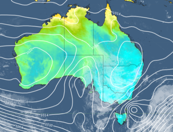
Even several inland towns near the Tropic of Capricorn fell perilously close to freezing overnight, including:
- Biloela (just south of the Tropic) had a low of 1.4°C. Interestingly, its minimum on the first day of winter, just three nights ago, was a very mild 17.3°C.
- Clermont (just north of the Tropic and therefore, officially “tropical”!) had a low of 1.1°C. Like Biloela, Clermont’s minimum on the first day of winter was exactly 17.3°C.
The good news for all the places mentioned is that daytime temps this week are still heading for tops of 20°C or higher, except for Kingaroy which won’t break out of the teens all week.
Brisbane will see tops in the low 20s for the rest of the week with mostly sunny skies.
How can DTN APAC help?
DTN APAC supplies precise weather intelligence to over 75% of the National Energy Market (NEM); and is the trusted provider for the Australian Energy Market Operator (AEMO).
Weatherzone’s next-generation nowcasting and forecasting system, OpticastTM, is independently proven to outperform other industry models, allowing energy traders to respond rapidly to changing conditions. From 14 day forecasting to seasonal outlooks, you have access to complete and powerful weather intelligence giving you the confidence to make the best call.
Meeting the needs of the changing market, Weatherzone utilises high-resolution modelling and local knowledge to provide 5-min granularity observations and forecasts, optimising your market bidding and maximising your profits. These, coupled with briefings from our energy meteorologists, give you full awareness of the associated risk.
Benefit from specialised indices such as apparent temperature, Cooling/Heating Degree Days (CDD/HDD) and Effective Degree Days (EDD) to help accurately predict demand. You can get a clear picture of forecast conditions across the market and quickly assess heat/heatwave potential from 14 days out to 12 months
No matter where your energy trading focus lies, we have the power generation and weather insights to inform your critical decisions, keeping you ahead of the curve. For more information please contact us at apac.sales@dtn.com.




