
Australia recorded its warmest spring on record, with also severe rainfall deficiencies occurring across parts of the country, setting the stage for high fire risk this summer.
The Australasian Fire and Emergency Services Authorities Council (AFAC) released their summer bushfire outlook for 2024 on Thursday, November 28, showing large areas of the NT, Vic and parts of NSW, WA and SA have an increased risk of bushfires this summer.
The red shading on the map below shows areas that have an increased risk of fires over the next three months. The remaining grey areas on the map have a near-normal risk of summer fires, according to the AFAC outlook.
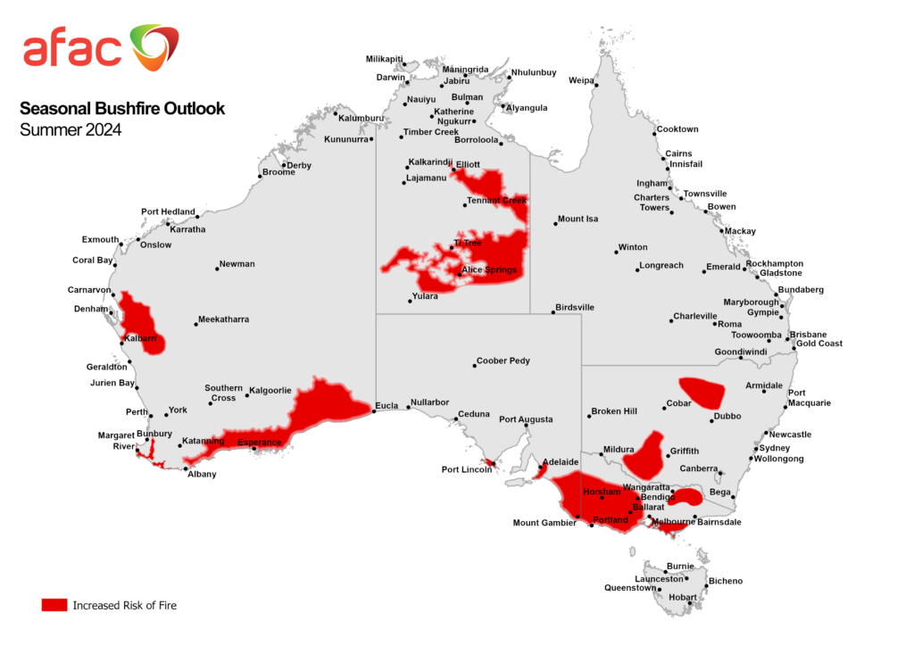
Image: Australian seasonal bushfire outlook for spring 2024. Source: AFAC
The AFAC outlook shows elevated fire danger across five states and territories because of:
- Forecast above average temperatures
- The Bureau has forecast drier conditions in mid to late summer across much of Australia, apart from the east of the country which should continue to be wet.
- Severe rainfall deficiencies and drought across parts of southern Australia.
- Winter spring rainfall which has led to substantial fuel loads in some areas
- The warmest spring on record which helped dry out and make materials flammable
- Unburnt areas across southern NT
Severe or serious rainfall deficiencies have been observed in northwest, southwest and far southern WA, southern and southeast SA, western and northeast Vic, southern NSW and the northwest and coastal fringes of Tas in the 15 months leading up to November 2024.
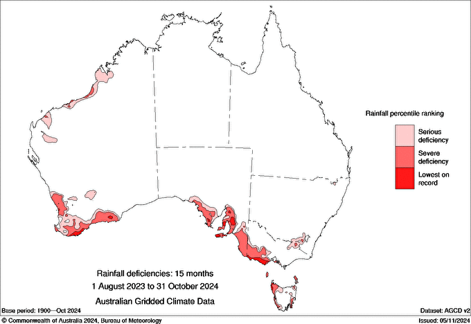
Image: Rainfall deficiencies during the 15-month period between August 1, 2023, and October 31, 2023. Source: BOM
The severe drought in these areas has resulted in large amounts of dry or dead plant material which are very flammable. A lack of autumn and winter spring rainfall was also observed across northeast Vic, the Mornington Peninsula, southwest Gippsland and Greater Melbourne and parts of central NSW, increasing the fire risk in these areas during summer.
Meanwhile normal fire risk is forecast for northern and eastern parts of Australia due to the imminent monsoon arrival in the north and above average rainfall forecast in the east. These areas should still remain vigilant during the summer months, if this wetter-than-average weather does not eventuate, the risk of fires will also be higher than normal.
Working in often severe conditions in the high-risk fields of forestry and emergency, our consolidated weather services can ensure full situational awareness for you and your team.
DTN APAC serves the forestry and emergency sectors, delivering trusted weather data and severe weather alerting to maintain safety, protect your assets and underpin your planning.
Weatherzone’s trusted nowcasting and forecasting system, OpticastTM, is independently proven to outperform other industry models, allowing you to respond rapidly to changing conditions. Opticast can ingest data from your on-site weather observation equipment, ensuring your forecast is customised to your local microclimate. From nowcasting and 14 day forecasting to seasonal outlooks, you have powerful, hyper-local weather alerting and intelligence, giving you decisive confidence when it’s most needed.
With lightning a prominent cause of forest fires throughout Australia, Weatherzone’s Total Lightning Network offers real-time detection and unsurpassed accuracy of lightning strikes to <200m. Based on a vast sensor network, both intra-cloud and cloud-to-ground strikes are located, ensuring you are alerted when severe weather is building and threatening your teams, assets and infrastructure. When volatile conditions increase the ferocity of fire it’s imperative you have lead-time to enact safety plans, keeping your people out of harm’s way.
Your weather intelligence is accessible across all devices in your network via our Weatherguard App, and your customisable interface.
We are there for you when you need us the most – 24/7, 365 days a year. For more information please visit our website or email us at sales.apac@dtn.com.
Title image credit: iStock /Binikins


