A stubborn area of high pressure has been entrenched to the south of Australia over the last few weeks, causing a lengthy run of repetitive weather across the country.
Weather systems in Earth’s mid-latitudes typically move from west to east. This includes the high and low pressure systems, cold fronts and low pressure troughs that pass over and near the southern half of Australia.
This alternating sequence of high and low pressure systems is what causes changes in the weather across Australia’s southern states, from warm to cold, dry to wet or calm to windy.
Meteorologists keep a close eye on weather systems approaching Australia from the west to know what changes in the weather are on the horizon.
In a typical weather pattern, each individual synoptic feature (e.g. a high pressure system or cold front) would take around 3 to 5 days to pass over the Australian region. However, these synoptic features can sometimes become stuck in place.
The most common cause of a stagnant weather pattern in the mid-latitudes is a blocking high pressure system. As the name suggests, this refers to a region of high pressure that sits in one place and blocks the passage of other synoptic features.
Blocking high pressure systems can occur anywhere in the mid-latitudes in both the Southern and Northern Hemispheres. Blocking highs have been responsible for intense heatwaves, flooding and other types of extreme weather, but they can also cause long spells of pleasant weather.
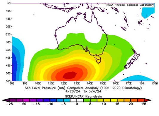
A blocking high has been lingering to the south of Australia over the last few weeks. In April, the mean sea level pressure off the south coast of WA was more than 10 hPa above average. This has continued into the first week of May, with mean sea level pressure to the south of Australia running more than 20 hPa above average in the week ending on May 4.

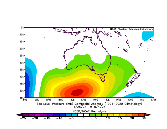
Images: Mean sea level pressure anomaly during April 2024 (top) and the seven days ending on May 4, 2024 (bottom). Source: NOAA / PSL
Because air circulates high pressure systems in an anti-clockwise direction in the Southern Hemisphere, blocking highs centred to the south of the country typically cause:
- Persistent onshore winds in eastern Australia, providing plenty of moisture for rain and thunderstorms in NSW and Qld
- Dry offshore winds along the west coast of Australia, making rain less likely
- Mild temperatures and less snow in southern Australia due to a lack of strong cold fronts
- Reduced rainfall in the south of SA and Vic, and western and southern Tas, also due to a lack of strong cold fronts
April’s rainfall distribution across Australia reflected the dominant influence of the blocking high pressure to the south of the country. Rainfall was below average in large areas of WA, SA and western Tas, while parts of NSW and Qld were much wetter than normal.

Image: Observed rainfall deciles in April 2024. Source: Bureau of Meteorology
The first fortnight of May is also turning out to be very wet for parts of eastern Australia due to the lingering blocking high centred to the south of Australia.
Sydney registered more than 6 mm of rain on each of the first six days in May. The last time there were six days this wet in Sydney was in 2022, also under the influence of a blocking high.
The map below shows the predicted rainfall over the next seven days, with widespread and heavy falls anticipated to continue in Australia’s eastern states.
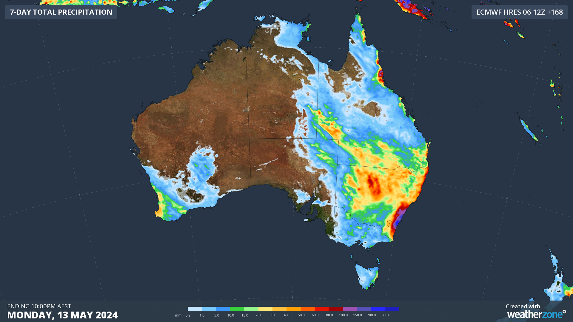
Image: Forecast accumulated rain during the seven days ending on Monday, May 13, 2024.
The presence of the unrelenting high pressure to the south of Australia also makes early-season snow less likely on Australia’s mountains in the first half of May.
Weatherzone Business has grown to become the outright leader within the Australian energy market, serving wind, solar, hydro, trading, utilities and network companies.
You can’t control the weather, but you can gain precision insights to optimise your response. What lights us up is providing your energy business with tailored weather information to reduce your risk and keep you moving ahead of the curve.
Our services cover all aspects – from wind and solar generation to demand forecasts, wholesale markets to retail so, no matter where your company sits, we have solutions for you. We have worked closely with market participants to create products that meet the evolving needs of the sector, aiming to increase safety and profitability for our customers.
Benefit from the timely delivery of accurate weather information, allowing informed and effective decision-making. For more information, please contact us at apac.sales@dtn.com.


