
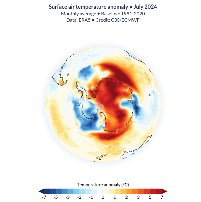
Earth’s Southern Hemisphere just experienced a 23-day run of record-breaking warmth, with air temperatures running about 1°C above average and at levels more typical of mid-spring than the middle of winter.
Values from the ECMWF Reanalysis 5 (ERA5) dataset show that the Southern Hemisphere set new surface air temperature records every day between July 19 and August 10, 2024.
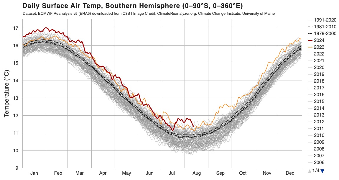
Image: Daily surface air temperatures in the Southern Hemisphere. The red line shows 2024 and the orange line is 2023. The thin grey lines represent all other years between 1940 and 2022. The dashed black lines represent the 30-year averages for three different climate periods (1979-2000, 1981-2010 and 1991-2020). Source: ClimateReanalyzer.org / ECMWF
Compared to the 1991-2020 climate, air temperatures in the Southern Hemisphere were about 0.6°C or more above average from July 19 to August 10. During this 23-day period, 10 days were around 0.9°C warmer than the 1991-2020 average and more than 1.0°C above the 1979-2000 average.
This recent run of record-breaking mid-winter warmth was driven by:
- The background warming influence of climate change
- Abnormally warm air sitting above and near Antarctica, which has links to recent episodes of sudden stratospheric warming in the polar stratosphere
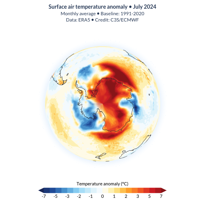
Image: Air temperature anomaly over the Antarctic region in July 2024. Source: CS3/ECMWF
Air temperatures and sea ice extent in the Antarctic region have both seen extreme highs and lows in recent weeks.
New surface air temperature records were set in the Antarctic region (south of 66.5°S) each day from August 2 to 9, while Antarctic sea ice extent currently sits at the second lowest area on record for this time of year.
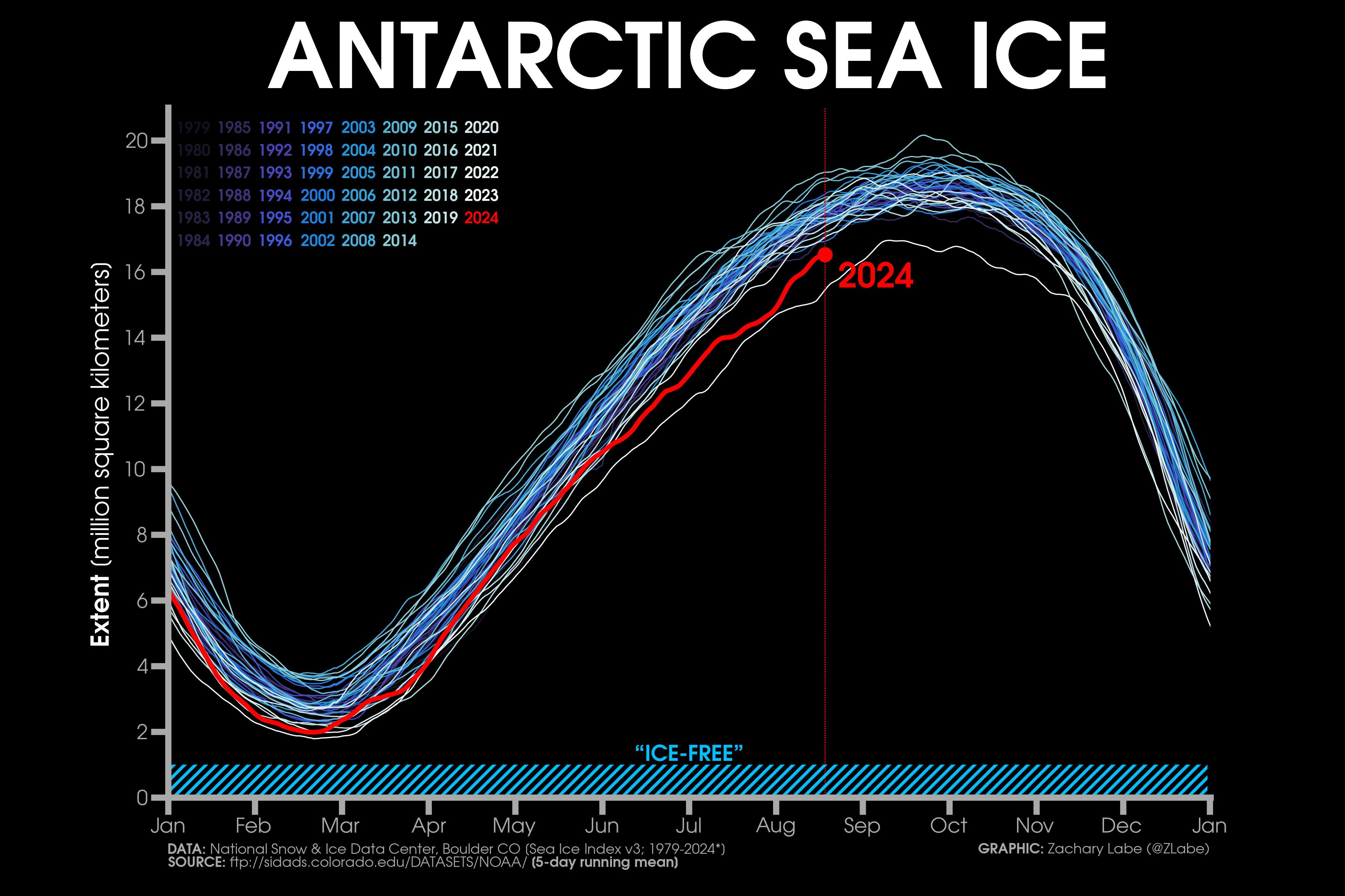
Image: Antarctic sea ice extent from 1979 to 2024. Source: zacklabe.com / NSIDC, DMSP SSM/I-SSMIS
With further stratospheric warming anticipated above the South Pole towards the end of August, we may continue to see abnormally warm air lingering over the Antarctic region as the Southern Hemisphere enters spring.\
The shifting climate is bringing increased complexity and greater risks to businesses worldwide. We are here for you, delivering trusted weather solutions to optimize your operations and profitability.
DTN APAC is a diverse team, with global forecasting, product development and analytics expertise. Couple this with extensive industry experience spanning Aviation to Energy, and we are primed to assist you in strengthening your response to weather
impact.
We work hard to identify your operational pressures and tailor our services and products to meet your needs. Concise communication, giving you full situational awareness exactly when you need it, is our focus. We want to reduce weather risk in your operations, every day.
We deliver clear and comprehensive weather data, personalised risk assessments and briefings to you and your team, so that your critical decisions can be made with confidence.
We are available 365 days a year, so you always have the timely guidance you require, especially when severe conditions hit.
You have our insights to rely on to see you through complex situations, minimising potential loss of profit and maximising the safety of your staff and assets. To find out more visit our contact page or email us at apac.sales@dtn.com.




