There are signs that another sudden stratospheric warming episode could occur above Antarctica towards the end of August, increasing the likelihood that the Southern Hemisphere’s polar vortex will continue to be disrupted into September. This event could have an ongoing influence on Australia’s weather patterns this spring.
What is Sudden Stratospheric Warming?
Sudden stratospheric warming (SSW) refers to an abrupt increase in air temperature in the polar stratosphere, which is a layer of the atmosphere roughly 30 to 40 km above Earth’s north and south polar regions.
Sudden warming in the polar stratosphere during winter or spring can disrupt the polar vortex, which can affect the behavior of weather patterns across the planet’s high and mid-latitudes in the following weeks and months.
The polar vortex is a large region of cold air and low pressure that sits above Earth’s polar regions throughout the year. Each polar vortex strengthens in winter, as polar temperatures plummet during months of darkness, and weakens in summer, as sunlight causes the air to become warmer above the poles.
Two periods of stratospheric warming have occurred above Antarctica in the past month, one in the middle of July and the second in early August. Both stratospheric warming episodes caused a negative Southern Annular Mode (SAM) to develop in the Southern Hemisphere.
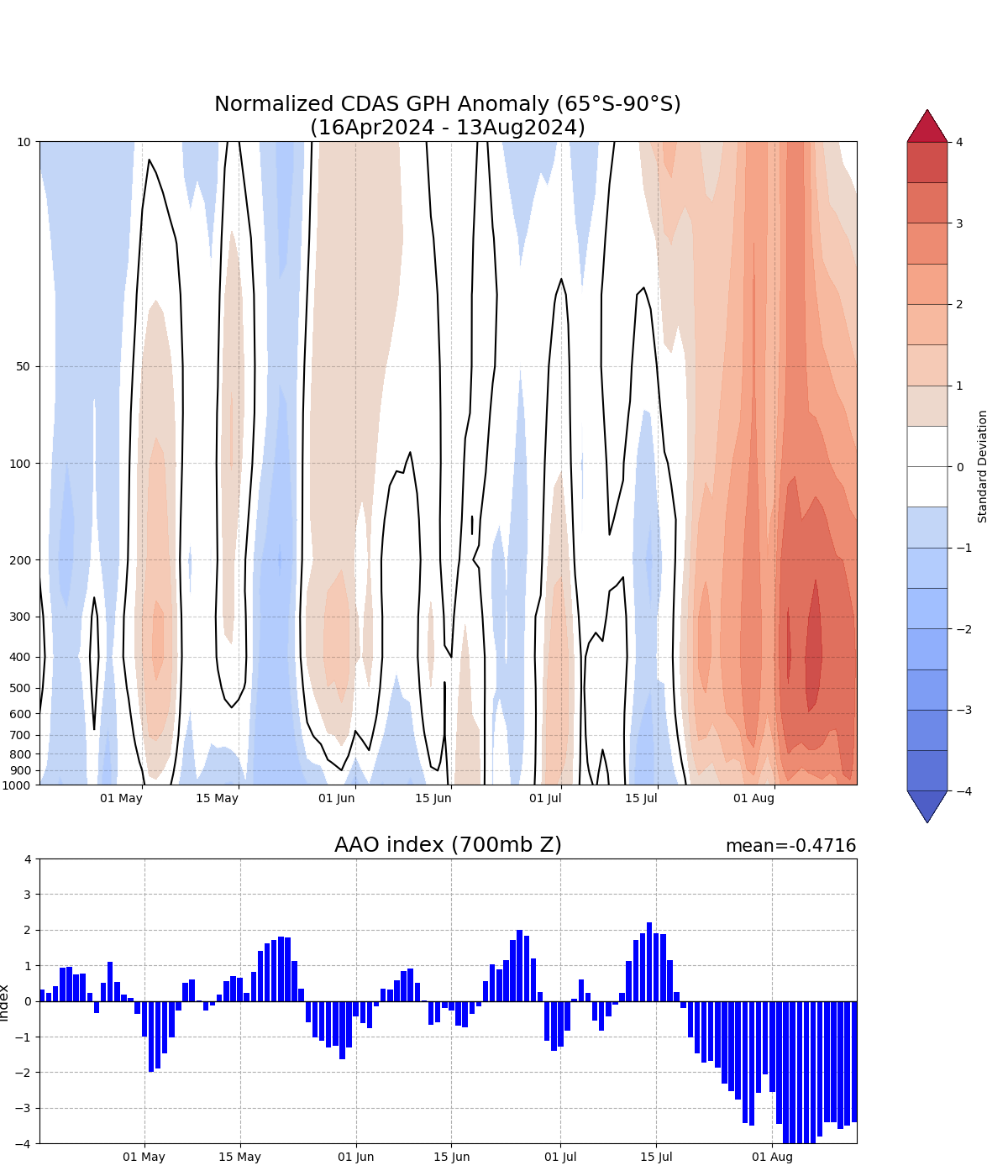
Image: Southern Annular Mode (SAM) index values (also called the AAO) during the last four months, showing a strong negative SAM associated with stratospheric warming since mid-July. Source: NOAA
Now, forecast models suggest that a third and potentially strong period of stratospheric warming could occur above Antarctica towards the end of August.
The images below show modelled air temperature and height at the 10 hPa level of the atmosphere, which gives a top-down view of the stratospheric polar vortex in the southern hemisphere. The first image shows the polar vortex on August 15, with a stable vortex holding cold air over Antarctica. The second image shows that by August 30, this model predicts a mass of warm air disrupting the polar vortex and shifting it away from the south pole.
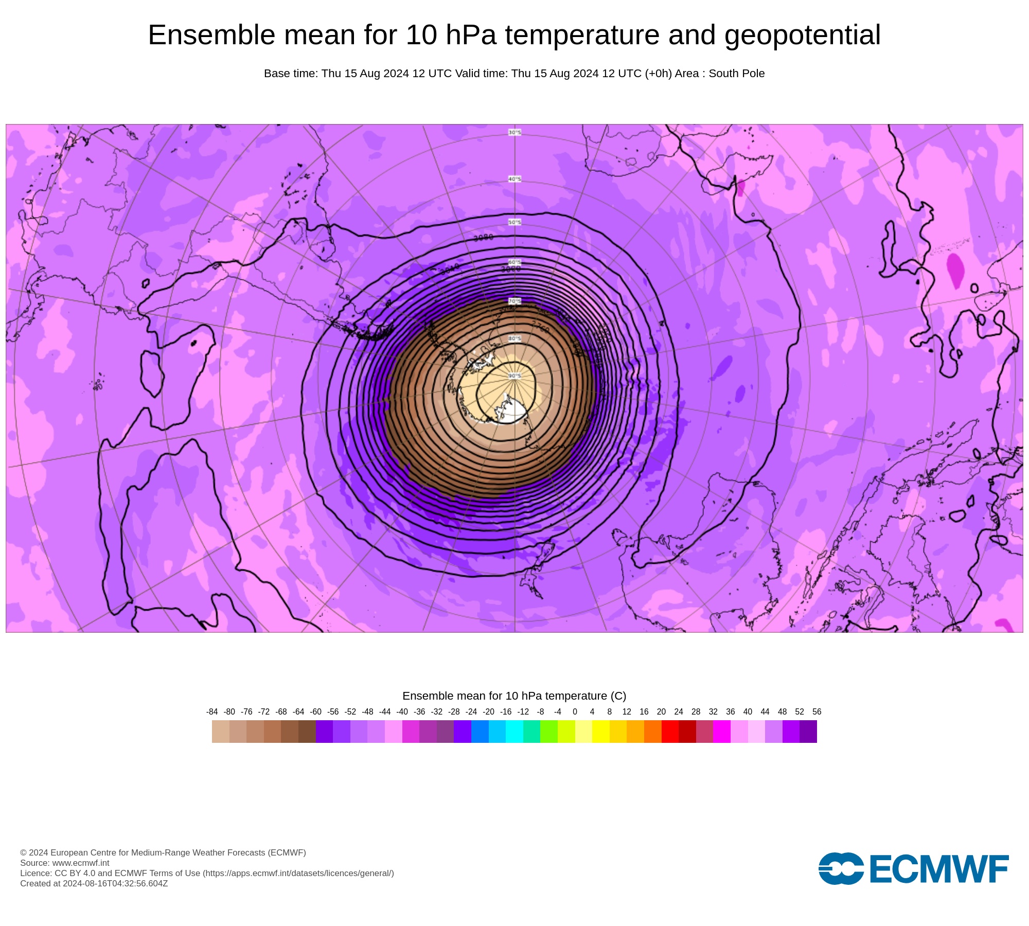
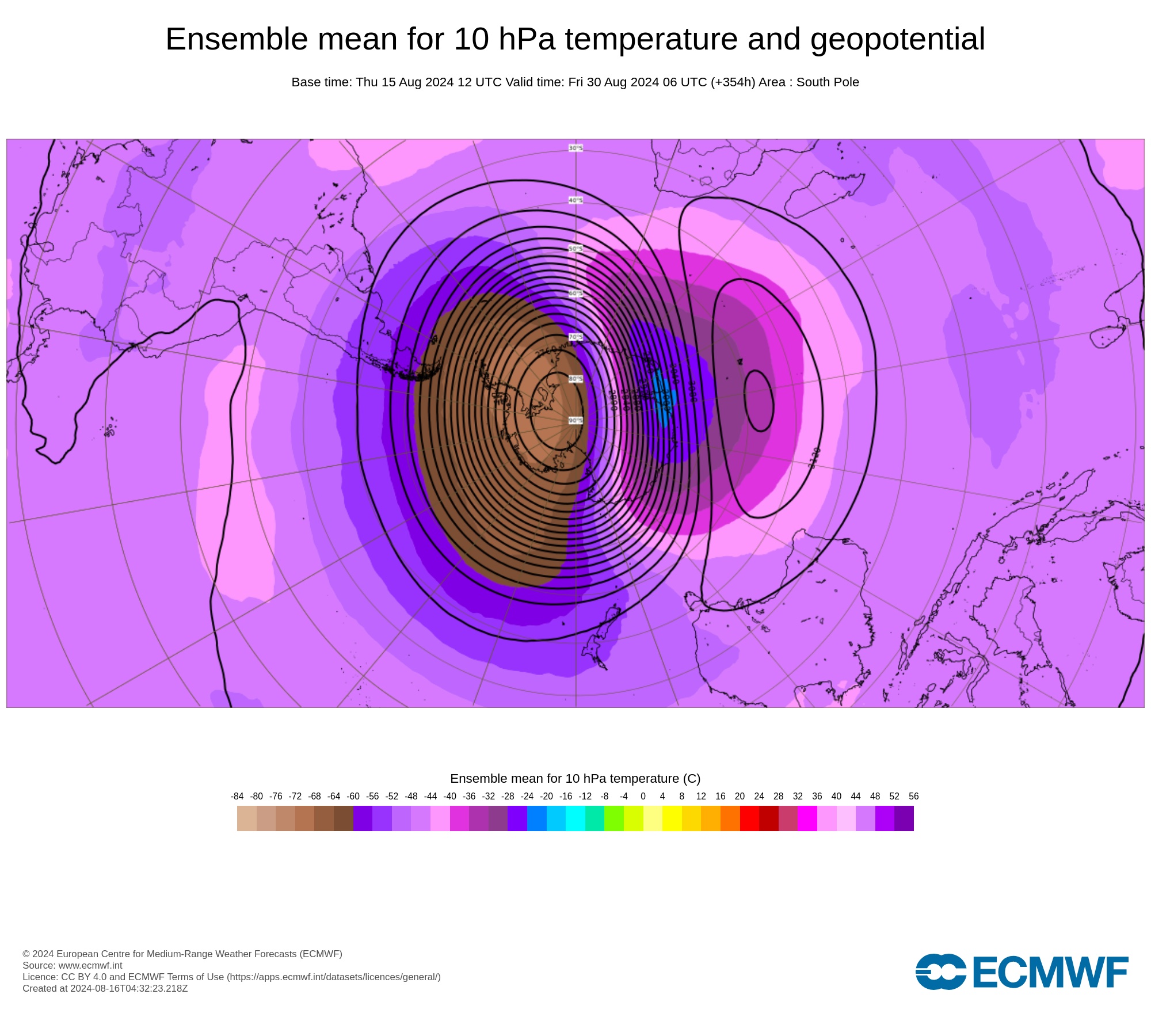
Images: Forecast air temperature and geopotential height at 10 hPa on August 15 (top) and August 30 (bottom), according to the ECMWF model. Source: ECMWF
Based on forecast model data, stratospheric air temperatures above East Antarctica could be more than 50°C warmer than average at the end of August. If this sudden stratospheric warming does occur, it would increase the likelihood that a negative SAM will persist in the southern hemisphere into early spring.
A negative SAM makes the following weather more likely in Australia during early spring:
- More cold fronts and low pressure systems over southern Australia, and enhanced westerly winds over much of the country
- Increased rainfall in parts of southwest and southeast Australia, particularly along the southern coastal regions
- Reduced rainfall in parts of eastern Australia
- Greater chance of warmer-than-average weather in central and eastern Australia, along with more fluctuations between warm and cool periods.
It’s too early to know if this stratospheric warming episode will continue to influence southern hemisphere weather patterns into late spring and beyond. However, if a negative SAM was to persist into late spring and early summer, which is possible following a sudden stratospheric warming event, it would increase the risk of abnormally dry and warm weather over large areas of eastern and southeastern Australia.
Weatherzone’s meteorologists will be keeping a close eye on the polar vortex and SAM in the coming weeks and giving regular updates on the Weatherzone News feed.
Weatherzone provide detailed seasonal updates to clients, with the information above plus more, to find out more visit our contact page or email us at apac.sales@dtn.com.


