The Fiji Meteorological Service and New Zealand’s National Institute of Water and Atmosphere Research (NIWA) both released their 2025-26 tropical cyclone outlooks last week, with elevated risks focused on New Caledonia, Vanuatu and New Zealand’s North Island.
The Fiji Meteorological Service is responsible for tropical cyclone services across the local Regional Specialized Meteorological Centre (RSMC) Nadi area. RSCM Nadi’s Area of Responsibility (AoR) borders Australia’s RSMC Darwin area from 160°E, extending past the International Dateline to 120°W, and running between 25°S and the equator.
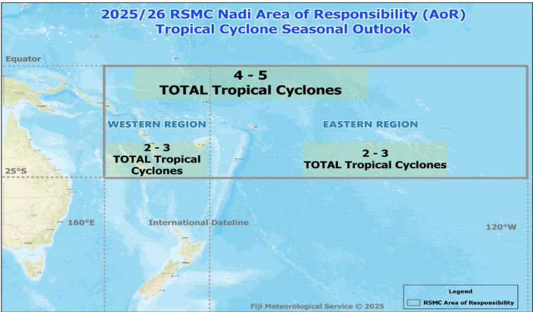
Image: The RSMC Nadi region, and the total number of tropical cyclones forecast during the 2025-26 season. Source: Fiji Meteorological Service
As seen in the image above, the Fiji Meteorological Service is forecasting:
- Four to five tropical cyclones across the AoR (below the long-term average of seven tropical cyclones per season).
- Two to three tropical cyclones both west and east of the international dateline (below the long-term average of around four tropical cyclones in each region).
While the number of tropical cyclones is forecast to be below the long-term average, severe tropical cyclones (category three or more) could be closer to average for the region, with a forecast for the 2025-26 season of:
- One to two severe tropical cyclones (long-term average of two) west of the dateline.
- Zero to one severe tropical cyclone (long-term average of two) east of the dateline with a lingering La Niña signal promoting cooler waters.
- One to three severe tropical cyclones across the region (near to below the long-term average of three).
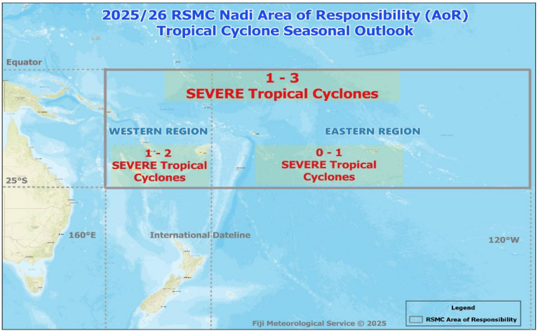
Image: Fiji Meteorological Service’s severe tropical cyclone 2025-26 season outlook. Source: Fiji Meteorological Service
For Fiji itself, the outlook is predicting one to two tropical cyclones to pass through Fiji’s Exclusive Economic Zone – one of which possibly becoming severe.
New Zealand’s National Institute of Water and Atmosphere Research (NIWA) outlook
While the Fiji Meteorological Serice’s RSMC Nadi is responsible for issuing tropical cyclone warnings and advisories over the region, New Zealand has close economic and cultural ties with the South Pacific region. NIWA also released their 2025-26 Southwest Pacific Island Tropical Cyclone season outlook last week, indicating normal to below normal tropical cyclone activity this season with:
- Five to nine named tropical cyclones (long-term average of around nine).
With La Niña conditions expected across the equatorial Pacific reducing the overall potential for south Pacific tropical cyclones, NIWA indicates normal or elevated tropical cyclone risk for Vanuatu, New Caledonia and northern New Zealand, with normal risk for Fiji, and reduced risk for more eastern Pacific nations.
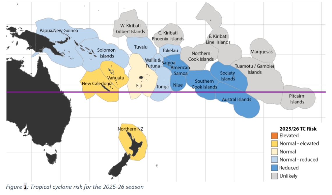
Image: Tropical cyclone risk for the 2025-26 season. Source: NIWA
Similarly to the Fiji Met outlook, NIWA also suggests a higher proportion of tropical cyclones reaching severe category three or more status this season.
The use of analogue years to evaluate tropical cyclone impacts
Both the Fiji Meteorology Service and NIWA reference analogue years in their outlooks. The analogue years feature similar conditions across the region, including La Niña conditions and very warm sea surface temperatures over the western parts of the Pacific. Comparison to past similar years helps evaluate the number, distribution and intensity of tropical cyclones that may develop in comparable years.
NIWA states “category 5 strength tropical cyclones, in which sustained winds are 200 km/h or greater, are associated with a majority of the analogue years.”
NIWA also states a “normal or elevated risk of at least one ex-TC passing within 550km of New Zealand, especially during late summer and autumn (when sea surface temperatures are warmest).”
With a focus on more western Pacific nations possibly seeing a greater number of severe tropical cyclones, significant impacts such as flooding rainfall, destructive winds, large surf, storm surge and coastal damages are all a risk for the upcoming 2025-26 southwest Pacific tropical cyclone season.
How DTN APAC supports south Pacific businesses and industries through tropical cyclones
DTN APAC specialises in industry-leading forecast, alerting and threat analysis of tropical cyclones across Australia, Asia and the south Pacific, offering you expert, customised solutions when the weather turns wild.
Providing rapid-update forecast information, we alert you to any low-pressure system gaining power within your region and, unlike other providers, can track its development out to 7 days. This gives you the time to prepare and safeguard your staff, sites and assets.
You will have the most precise weather intelligence charting rainfall, wind speeds and potential storm surges to help you make critical decisions quickly. Whether it’s adjusting key work schedules, protecting your staff or securing your site, we have the alerting capability to keep you steps ahead of the storm.
As the climate delivers increasingly severe weather events, their potential to impact your business operations grows.
Whether it’s preparing for the coming season’s tropical storm potential, or rapid-response forecasting with a tropical cyclone approaching, or simply ensuring your operations team is equipped to confidently make decisions ahead of severe weather, our weather Risk Communicators are here for you.
Our weather risk communicators deliver short- to long-term guidance from:
- hourly-event weather monitoring (alerting you of impending destructive winds and heavy rain ahead of a tropical cyclone).
- week to month operational planning based on likely timing of increased monsoonal rain or periods of reduced cyclone activity.
- seasonal long term planning based on climate drivers and the likely trends across the coming months.
We deliver clear and comprehensive weather data, personalised risk assessments and briefings to you and your team, so that your critical decisions can be made with confidence.
We are available 365 days a year, so you always have the timely guidance you require, especially when severe conditions hit.
You have our insights to rely on to see you through complex situations, minimising potential loss of profit and maximising the safety of your staff and assets.
Learn more about our large range of industry leading products and services or email us at sales.apac@dtn.com


