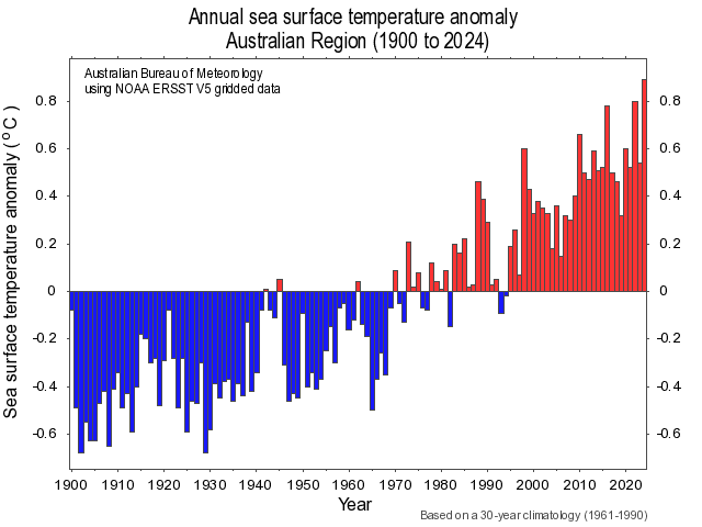
The Australian region set a new record for ocean temperatures in 2024, with sea surface temperatures close to 0.9°C above the long-term average.
Australia’s annual mean sea surface temperature during 2024 was 0.89°C above the 1961-1990 average. This was the highest annual sea surface temperature on record, beating the previous record anomaly of +0.80°C from 2022.

Image: Annual sea surface temperature anomalies in the Australian region between 1900 and 2024. Source: Bureau of Meteorology
January, February, October, November and December all set new records for their respective months. Every other month in 2024 ranked among the top three warmest on record for their respective months, based on data dating back to 1900.
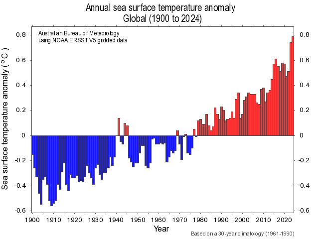
The abnormally warm water surrounding Australia over the last 12 months was part of a larger story of record-breaking global oceanic heat in 2024.
According to data published by the Bureau of Meteorology, Earth’s global average annual sea surface temperature in 2024 was about 0.79°C above the 1960-1990 average. This is also a record, beating 0.74°C from 2023, despite the cooling influence of a La Niña-like pattern, which typically lowers the average global temperature.

Image: Global annual sea surface temperature anomalies between 1900 and 2024. Source: Bureau of Meteorology
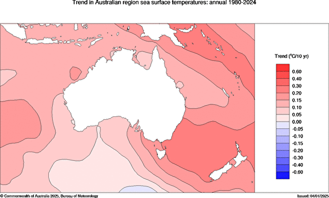
The graphs above reveal a clear warming trend in ocean temperatures. In the Australian region, sea surface temperatures have warmed by around 1.1°C since 1910 and warming has occurred around the entire country.

Image: Trend in sea surface temperatures near Australia between 1980 and 2024. Source: Bureau of Meteorology
The warm water surrounding Australia in 2024 was one of the reasons the country registered its second warmest year on record based on air temperature. It also helped make the air over Australia more humid than usual.
To find out more about how these SSTs could impact your business, please visit our website or email us at sales.apac@dtn.com.


