
Australia should experience summer without the influence of major climate drivers like La Niña or a negative IOD, potentially heightening the risk of heatwaves, extreme heat and bushfires across parts of the country.
Pacific Ocean climate driver
During much of 2024, the sea surface temperatures across the central and eastern Pacific have been cooler than average, hinting at a potential La Niña developing in 2024.

Image: Sea surface temperature anomalies in the Pacific Ocean on December 1, 2024. The map shows a classic La Niña-like pattern, with cooler-than-average water in the central and eastern equatorial Pacific Ocean. Source: NOAA.
La Niña is a broad-scale circulation in the Pacific Ocean that is characterised by warmer-than-average sea surface temperatures to the northeast of Australia and abnormally cool water in the central and eastern equatorial Pacific Ocean.
The image above shows a pattern like this which is why the Bureau issued a La Niña Watch earlier this year, meaning that there is a 50% chance of a La Niña developing this year, or about twice the normal likelihood.
If La Niña was to occur this summer, it could typically cause:
- Increased rainfall across much of Australia
- Milder daytime temperatures
- Warmer nighttime temperatures in the north
- Greater risk of Tropical Cyclones
- Earlier onset to the monsoon
- Increased risk of heatwaves, but at a lower intensity
- Increased humidity
La Niña is one of three phases of the El Niño-Southern Oscillation, with the other two phases being El Niño and neutral (neither La Niña nor El Niño).
We have entered summer in a neutral phase of the El Niño-Southern Oscillation, which usually brings ‘normal’ summer weather to Australia.
Recent observations of the Nino 3.4 index show that the Sea Surface Temperatures anomalies in the central equatorial pacific have moved away from the La Nina threshold of -0.8ºC and toward the neutral phase.
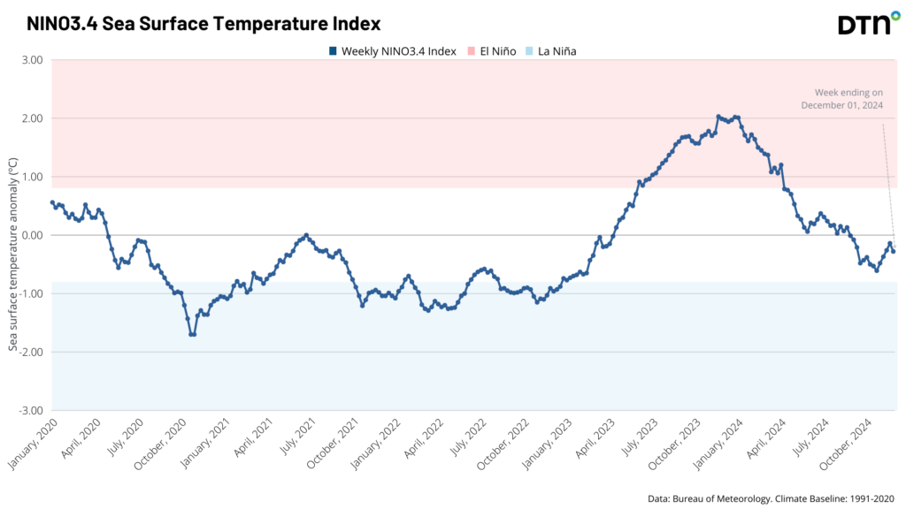
Both the Niño 3.4 or 3 indices have not yet met the Bureau’s criteria for declaring La Niña. However, this is not the only criteria used by the Bureau and any three of the following criteria can be used to declare La Niña:
- Niño 3.4 and 3 indices below -0.8°C
- Trade winds in the central or western Pacific Ocean stronger than average during any three of the last four months
- Southern Oscillation Index (SOI) is +7 or higher for a three-month average.
- Majority of models show sustained values below -0.8°C for the Nino3 and Nino3.4 regions
Currently only one of these criteria has been met, with stronger trade winds occurring across the western Pacific. The three-month SOI index is 3.7, which is well within neutral boundaries and is unlikely to make this criterion in at least the next three months.
The majority of climate models are predicting neutral conditions this summer. Only two out of the seven models surveyed by the Bureau of Meteorology are predicting La Niña for December, as shown below.
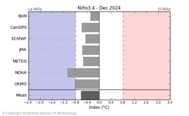
Image: Global climate model Niño3.4 index forecasts for December 2024. Source: Bureau of Meteorology.
While the Bureau is unlikely to declare La Niña this summer, the US Climate Prediction Centre (CPC) and Columbia University’s International Research Institute for Climate and Society (IRI) predict that there is a 74% chance of the La Niña phase of the climate driver emerging this year. However, their La Niña threshold for the Nino 3.4 index of -0.5°C is less extreme than the Bureau’s which is -0.8°C, and therefore easier to meet.
Regardless of the Bureau’s declaration, Australia could see La Niña-like conditions develop during early to mid-summer increasing the chance of rainfall across northern and eastern Australia.
Indian Ocean climate driver
Another major climate driver for Australia is the Indian Ocean Dipole (IOD), which is an index that measures the difference in sea surface temperatures across the tropical Indian Ocean.
A negative IOD occurs when cooler-than-average water sits on the western side of the Indian Ocean, near the Horn of Africa, and warmer-than-average water lies on the eastern side of the Indian Ocean, near Indonesia. A positive IOD is the opposite of this pattern (cooler water in the east, warmer in the west).
Each phase of the IOD also influences atmospheric conditions above the Indian Ocean and surrounding countries. For Australia, a negative IOD typically increases the likelihood of above average rain over large areas of the country, while also promoting cooler days in the country’s south and east.
IOD events typically occur between May and November and break down when the monsoon arrives in summer.
The IOD index had been in a predominantly negative phase over the last couple of months, since mid-October, however it has recently jumped back into neutral conditions.
While it had been negative for weeks, the Bureau typically does not declare a negative IOD event unless the index is below the -0.4°C threshold for at least eight weeks.
While the IOD has been officially neutral and will continue to be with the arrival of the monsoon expected in December, the brief negative phase seen in recent weeks has been causing above average rainfall and storm activity across large areas of Australia.
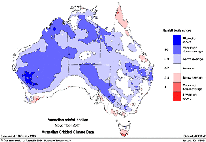
Image: Australian rainfall deciles for November 2024. Source: BOM
The rainfall in November and also the opening days of December most likely has been caused in part by this negative IOD-like pattern, which is associated with much warmer than average Sea Surface Temperatures (SSTs) off the northwest shelf of Australia.
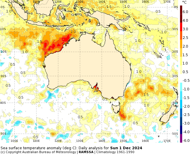
Image: Sea surface temperature anomaly for Sunday, December 1. Source BOM
The unusually warm waters to the northwest of WA are enhancing the moisture in the atmosphere in the region, which is being transported towards the countries southeast by frequent northwest cloud bands.
While the IOD is expected to be neutral in the coming months, these warm waters could continue to enhance rainfall across parts of Australia this summer.
The ocean temperatures to the country’s southeast are also abnormally warm, which could increase the potential for rain, thunderstorms and humidity over eastern Australia in the coming months.
Eastern Australia could also see enhanced easterly winds this summer thanks to prolonged phases of positive SAM. This may enhance rain and storm activity in the country’s east and southeast in the months ahead.
What to expect this summer
During early December, large parts of the country are forecast to be wetter than average due to the warm SSTs surrounding much of Australia, along with the influence of La Niña-like conditions and the likely arrival of the monsoon.
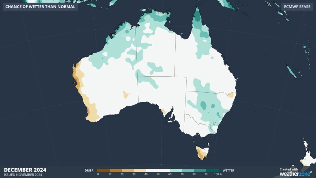
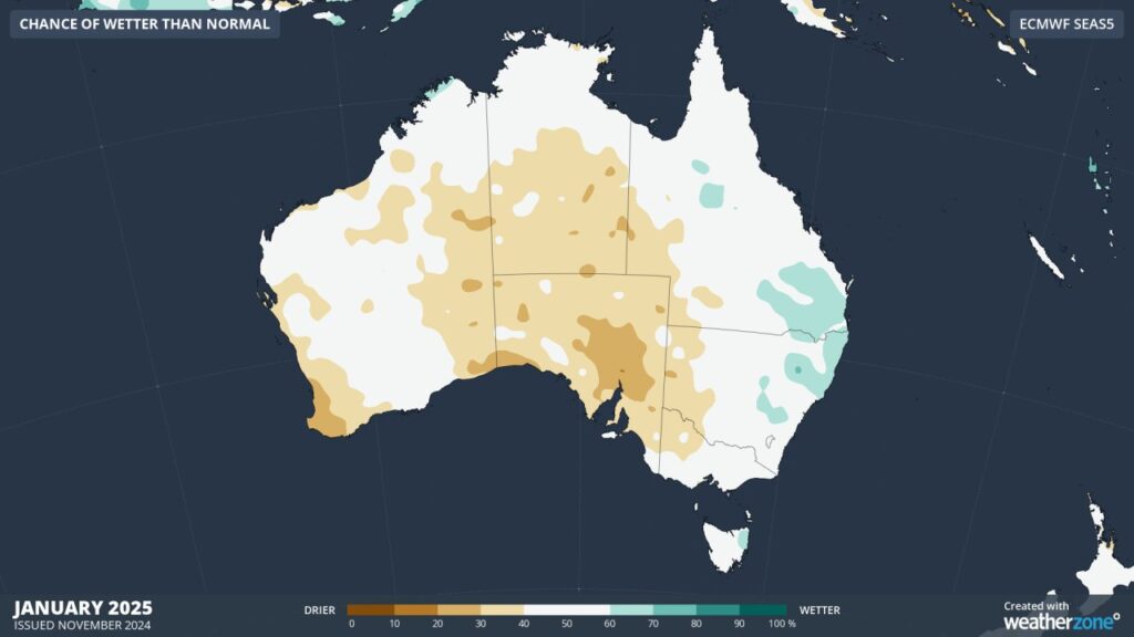
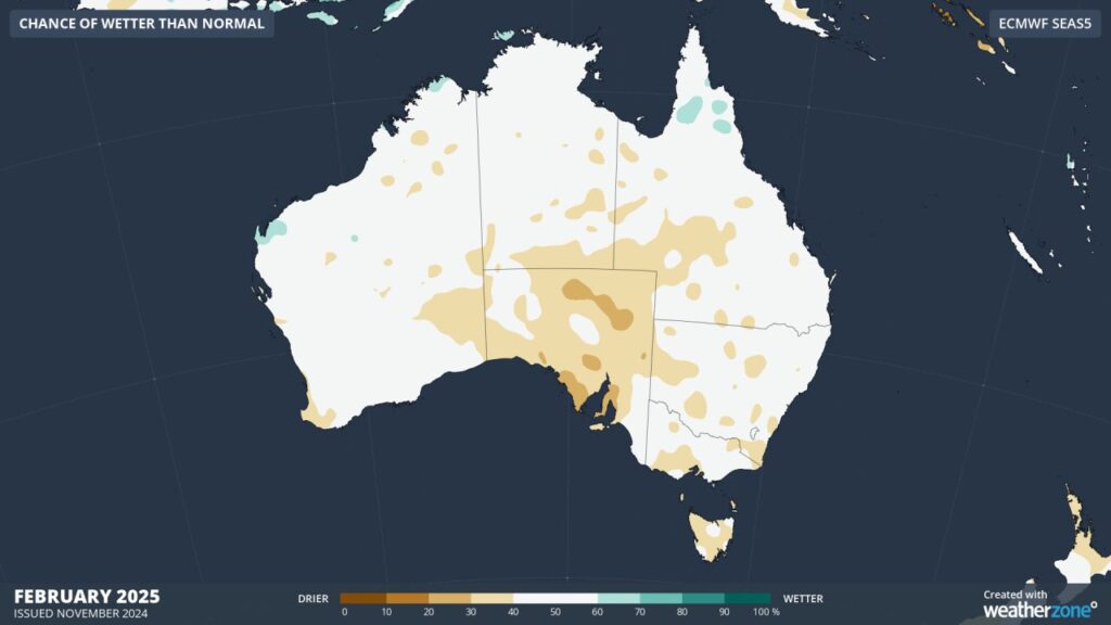 Images: Chance of wetter than normal forecast for the summer months according to the ECMWF-SEAS5 model
You can see in the maps above that later in summer, much of Australia is forecast to become drier than average, except for pockets of eastern Australia. Despite the rainfall signal in early summer, daytime and nighttime temperatures are forecast to be warmer than average across the country.
With La Niña and the negative IOD unlikely to occur, Australia faces an increased risk of extreme heat and bushfires this summer.
Large areas of the NT, Vic and parts of NSW, WA and SA have an increased risk of bushfires this summer, with dry and warm conditions forecast to continue.
The shifting climate is bringing increased complexity and greater risks to businesses worldwide. We are here for you, delivering trusted weather solutions to optimize your operations and profitability.
DTN APAC is a diverse team, with global forecasting, product development and analytics expertise. Couple this with extensive industry experience spanning Aviation to Energy, and we are primed to assist you in strengthening your response to weather
impact.
We work hard to identify your operational pressures and tailor our services and products to meet your needs. Concise communication, giving you full situational awareness exactly when you need it, is our focus. We want to reduce weather risk in your operations, every day.
We deliver clear and comprehensive weather data, personalised risk assessments and briefings to you and your team, so that your critical decisions can be made with confidence.
We are available 365 days a year, so you always have the timely guidance you require, especially when severe conditions hit.
You have our insights to rely on to see you through complex situations, minimising potential loss of profit and maximising the safety of your staff and assets. For more information please visit our website or email us at sales.apac@dtn.com.
Title image credit: iStock /valio84sl


