
There are increasing signs that a positive Indian Ocean Dipole could develop this winter, increasing the chance of abnormally dry and warm weather in some parts of Australia over the coming months.
What is the Indian Ocean Dipole?
The Indian Ocean Dipole (IOD) is an index that measures the difference between sea surface temperatures on the eastern and western sides of the Indian Ocean. There are three phases of the IOD: positive, negative and neutral.
The IOD index is positive when warmer-than-usual water develops near Africa’s east coast and cooler-than-usual water forms off the northwest coast of Australia, near Indonesia.
.png)
How does the IOD impact Australia?
The phases of the IOD have a strong correlation with rainfall and temperature patterns in Australia. A positive IOD impacts Australia in the following ways;
- Can bring below-average rain and reduce the chances of flooding over much of Australia.
- It also can promote warm daytime temperatures over large parts of Australia and can increase the intensity of heatwaves.
- Nighttime temperatures can be cooler due to clear skies allowing the temperature to drop, which can increase frost risk in spring and winter.
- They increase fire danger in some parts of the county, especially southeastern Australia.
The images below show how eight positive IOD years have affected daytime temperatures and rainfall across Australia.
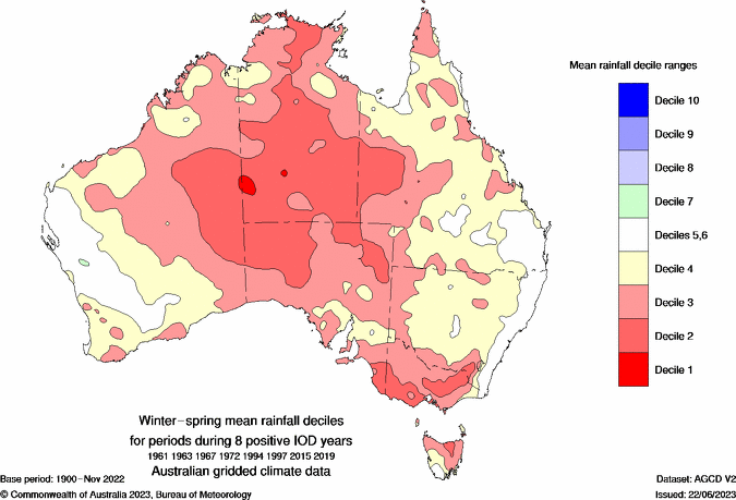
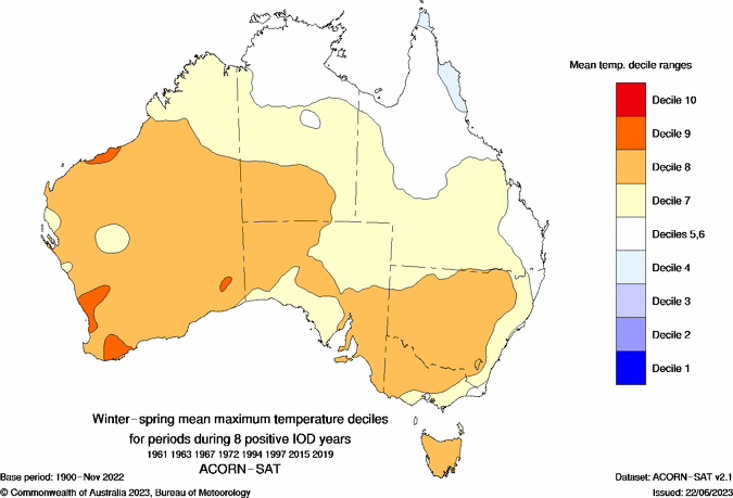
Image: Winter-spring rainfall and maximum temperature deciles for 8 positive IOD years. Source: Bureau of Meteorology.
Signs a positive IOD could develop in 2024
There are several indicators in both the atmosphere and Indian Ocean that a positive IOD could develop this year.
The first is a tropical cyclone that is forecast to form in the Bay of Bengal later this week.
According to researchers, strong tropical cyclones that develop in the Bay of Bengal during April and May can be a trigger mechanism for a positive IOD developing later in the same year. This relationship occurs because tropical cyclones over the Bay of Bengal can force broad-scale changes in the atmosphere and ocean that help initiate a positive IOD event.
A recent example of this was Severe Tropical Cyclone Mocha, which formed in the Bay of Bengal in early May last year. This cyclone proceeded the strong positive IOD event that formed in winter and spring 2023.
The map below shows that gale force winds are forecast to be whipping around a tropical cyclone in the Bay of Bengal by this Saturday morning.
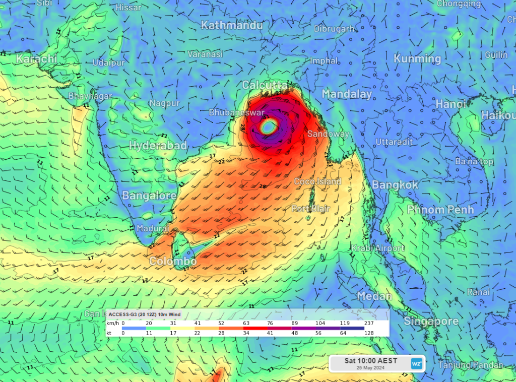
Image: 10 metre wind forecast for 10am AEST on Saturday, May 25, according to Access-G
Computer models are indicating that this tropical cyclone could become severe over the weekend, however this will depend on how much time it spends over water before crossing the eastern Indian coastline.
If we do see a severe tropical cyclone over the Bay of Bengal this weekend, it would increase the likelihood of a positive IOD forming this winter. However, it is worth pointing out that while a Bay of Bengal tropical cyclone can help a positive IOD event develop, it does not guarantee it.
The second sign that we could be heading towards a positive IOD event is that southeasterly winds have increased in the last 20-30 days over the equatorial Indian Ocean.
The charts below compare the difference in southeasterly wind speeds across this region between late March and mid-April (top) and Mid-April to Mid-May (bottom).
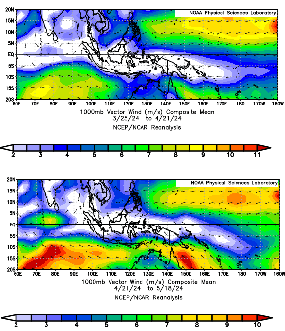
Image: 1000mb composite mean vector wind (m/s) between March 25 and April 21 (top) and April 21 and May 18 (bottom).
These southeasterly winds are likely to be behind upwelling of cold waters that has been observed off the Java Coast, Indonesia in recent weeks. The upwelling of cool water coming to the surface forces warmer waters to travel westward towards Africa. This process of cool deep water replacing warmer surface water near Indonesia can initiate a positive IOD.
The map below shows that these cool waters are currently located just outside of the IOD east region, which is why we have seen the IOD index drop back into neutral territory during the last three weeks.
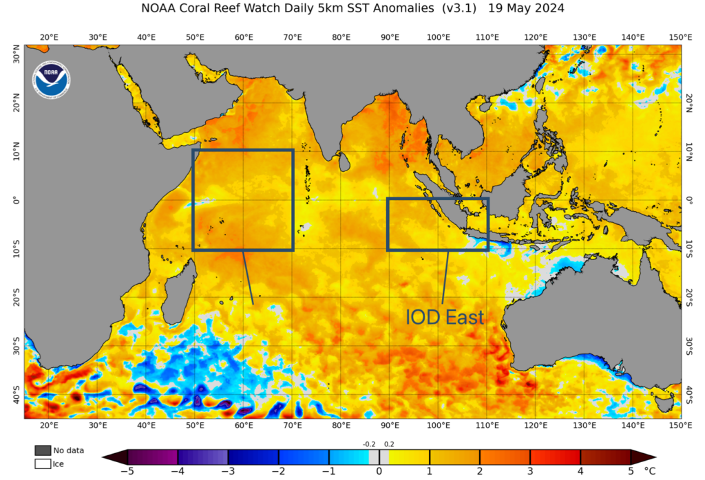
Image: Sea surface temperature anomalies in the Indian Ocean on May 19, 2024, showing warm water in the IOD west and East box, with cool water just outside the east region. Source:NOAA
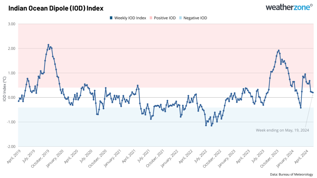
The chart below shows that the index was positive for the seven weeks leading up to Monday, May 5. However, the index has indeed become neutral in recent weeks, thanks to the warmer waters in the IOD East region.
Most international computer models are predicting that the IOD could become positive this winter and possibly persist in this phase until early spring, before returning to neutral by mid-spring.
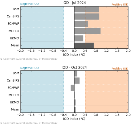
Images: International climate models IOD forecast for July (top) and October (bottom) 2024. Source: Bureau of Meteorology.
You can see in the images above that almost all climate models surveyed by the Bureau of Meteorology predict that this event, if it happens, will be short lived and should return to neutral by October.
While there are several indicators suggesting that we could see a positive IOD developing in the middle of this year, this event is not set in stone just yet. The next month will be make or break for this event, so we will keep you updated in the coming weeks.