
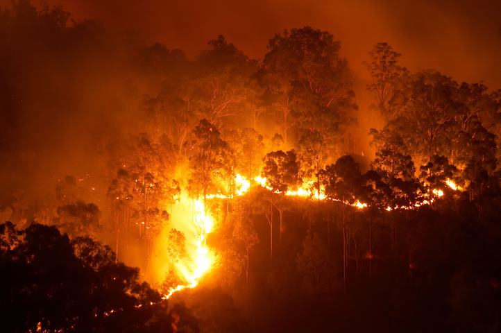
The 2019-20 ‘Black Summer’ bushfire season was catastrophic for parts of eastern Australian and the worst fire season NSW has recorded. Now, with more hot and dry weather forecast this spring and summer, some people may be wondering if this fire season will be as bad as the 2019-20 Black Summer.
What conditions contribute to a bad fire season?
Hot, dry and windy conditions, along with dry lightning, can increase the frequency, size, intensity and speed of bushfires, making them more dangerous. Dry vegetation is also a key factor in dangerous fire seasons like black summer.
Australia’s worst fire seasons have typically been marked by hot, dry and windy conditions that occur on the back of several years of drought.
These seasons are often caused by a “perfect storm” or combination of El Niño, negative phases of the Southern Annular Mode (SAM), positive phases of the Indian Ocean Dipole (IOD) and climate change.
During El Niño, we often see warmer and drier conditions over large areas of Australia. This weather can contribute to droughts, bushfires, extreme heat and heatwaves. While El Niño is a natural occurrence, the background warming caused by climate change has also caused El Niño years to become warmer in recent decades.
Positive phases of the IOD also cause below average rainfall and above average temperatures in winter and spring for large parts of Australia.
Negative phases of the SAM typically cause strong and dry westerly winds to persist over Southern Australia, as cold fronts are displaced further north than normal for the time of year. These lingering strong westerly winds can promote warm, dry and windy weather across eastern parts of the country, increasing the risk of fires.
What climate drivers were at play in the 2019/20 black summer?
The weather of the infamous 2019-20 Black Summer was underpinned by neutral conditions in the Pacific Ocean, a strong positive Indian Ocean Dipole (IOD) and a prolonged negative phase of the Southern Annular Mode (SAM).
Both the IOD and SAM contributed to the heat and lack of rain in NSW during late 2019 and early 2020. At the same time, the neutral Pacific Ocean failed to deliver much-needed rain that is more common during La Niña.
The Black Summer bushfire season in 2019-20 was exceptionally hot and dry and it came at the end of a multi-year drought in NSW.
The image below shows parts of southeastern Australia saw their lowest rainfall on record during the three-year period ending in December 2019, with devasting drought affecting much of this area.
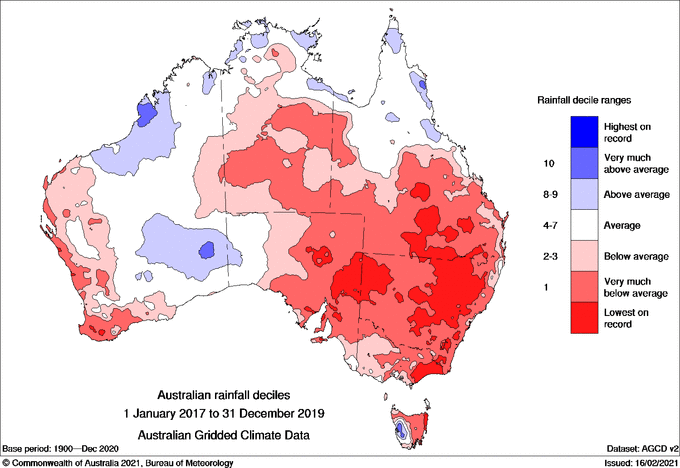
Image: Rainfall deciles for the three-year period from January 2017 to December 2019. Source: Bureau of Meteorology.
How do current climate drivers compare to Black Summer?
Fast forward to the past three years leading up to this season and the state of climate drivers influencing Australia’s weather were dramatically different to the 2017-19 period.
Three consecutive La Niña events occurred in the Pacific Ocean between 2020 and 2023. Throughout this time, the IOD was mostly neutral or negative and the SAM was almost always in a positive phase. This mix of wet-phase climate drivers boosted rainfall and suppressed daytime heat across large parts of the country, particularly in eastern Australia
As a result, much of Australia saw relatively quiet fire seasons during the 2020, 2021 and 2022 due to cooler temperatures and above average rainfall and soil moisture.
The map below shows much of Australia received very much above average rainfall in the 24 months leading up to August 2023, with a few pockets of NSW, northern WA and QLD receiving their highest rainfall on record.

Image: Rainfall deciles for the three-year period from August 2020 to July 2023. Source: Bureau of Meteorology.
The above average rainfall in the years leading up to this season caused vast areas of green vegetation across the continent, and higher soil moisture across central and northern Australia compared to 2019.
The images below show how much more live green vegetation there was in June 2023 than June 2019.
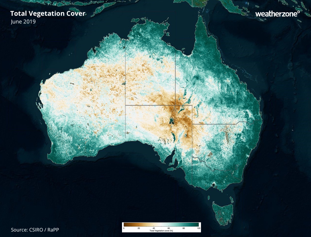
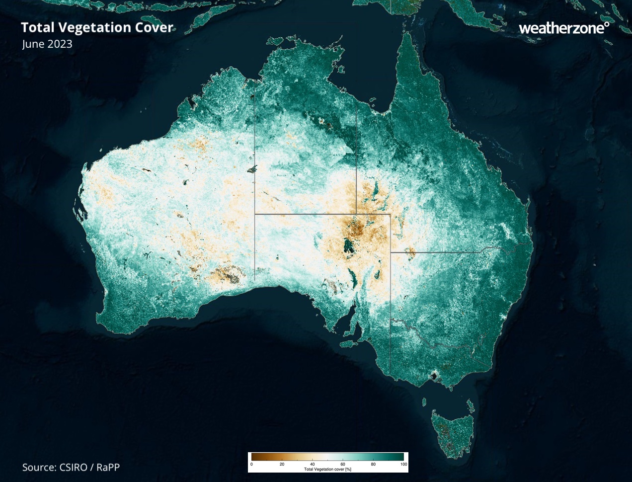
Image: Total vegetation cover in June 2019 (top) and June 2023 (bottom). Source: CSIRO / RaPP
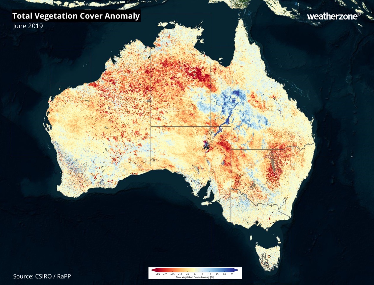
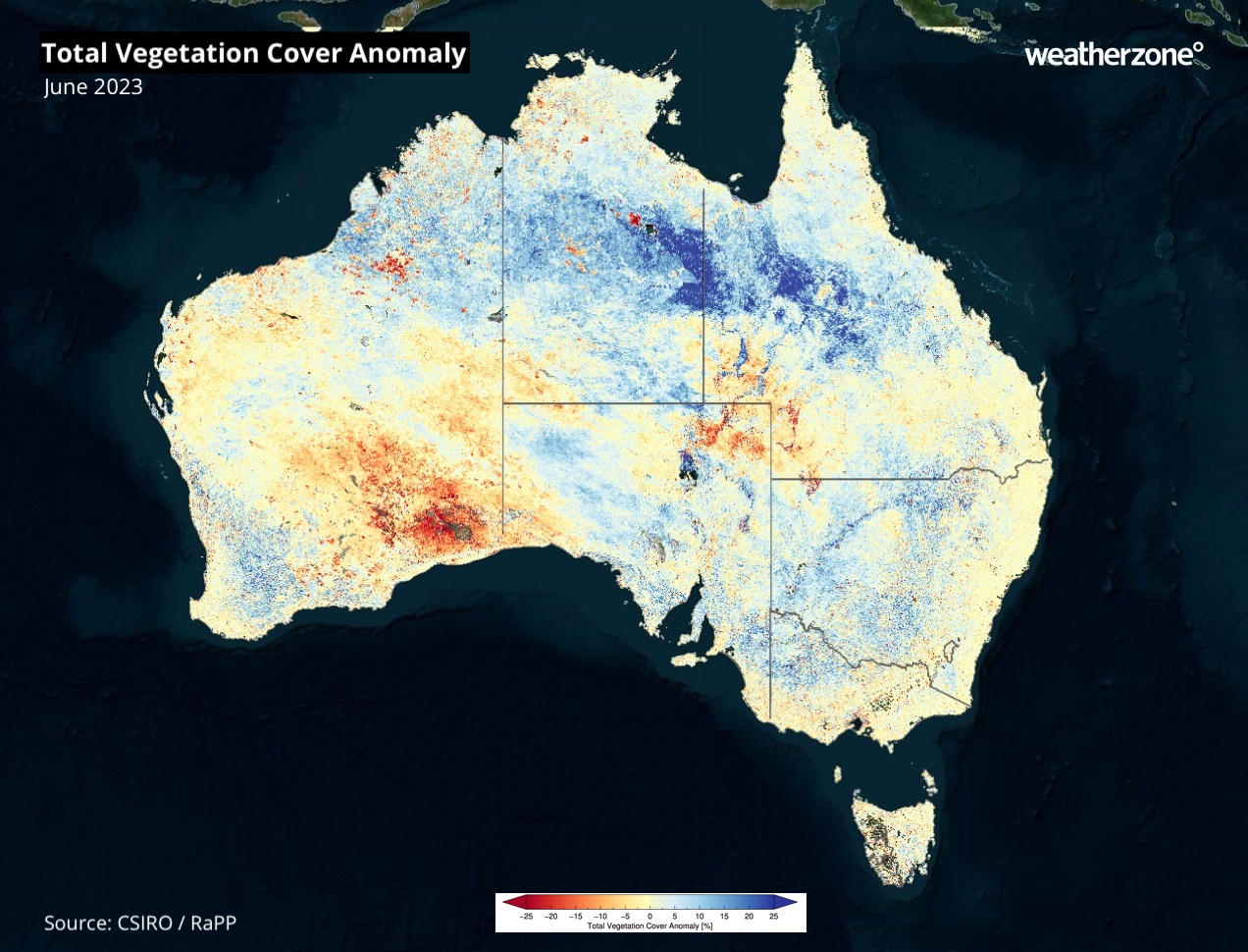
Image: Total vegetation cover anomaly in June 2019 (top) and June 2023 (bottom). Source: CSIRO / RaPP
Will this fire season be as dangerous as the 2019/20 black summer?
Most forecast models are predicting El Niño and a positive IOD during the second half of 2023. If these climate drivers develop, they will promote abnormally warm and dry weather in Australia, which is likely to increase the risk of fires.
However, these dry phase climate drivers will be occurring off the back of a run if wet years in Australia, which should help offset their influence this fire season.
So, while some parts of Australia may see an active fire season this spring and summer, it is unlikely to match the severity of the 2019-20 Black Summer.
How can Weatherzone help this fire season?
Working in often severe conditions in the high-risk fields of forestry and emergency, our consolidated weather services can ensure full situational awareness for you and your team.
DTN APAC serves the forestry and emergency sectors, delivering trusted weather data and severe weather alerting to maintain safety, protect your assets and underpin your planning.
With lightning a prominent cause of forest fires throughout Australia, Weatherzone’s Total Lightning Network offers real-time detection and unsurpassed accuracy of lightning strikes to <200m. Based on a vast sensor network, both intra-cloud and cloud-to-ground strikes are located, ensuring you are alerted when severe weather is building and threatening your teams, assets and infrastructure. When volatile conditions increase the ferocity of fire it’s imperative you have lead-time to enact safety plans, keeping your people out of harm’s way.
Your weather intelligence is accessible across all devices in your network via our Weatherguard App, and your customisable interface.
We are there for you when you need us the most – 24/7, 365 days a year. For more information, please contact us at apac.sales@dtn.com




