

The hot and dry weather associated with El Niño should persist into Autumn next year as the event continues to strengthen.
El Niño was officially declared by the Bureau of Meteorology in September on the back of three consecutive La Nina years.
El Niño is a major climate driver which is characterised by unusually warm oceans in the central and eastern Pacific and cooler waters surrounding northern Australia. This pattern leads to weakened or reversed trade winds which moves moisture away from Australia.
This pattern causes below average rain and cloud across much of Australia and can lead to droughts. Heat extremes are also common during El Niño years.
This week, the Niño-3.4 index reached 1.78ºC after warming progressively during the last month or so. This is the highest value in three months and shows that this El Niño is a moderately strong event.
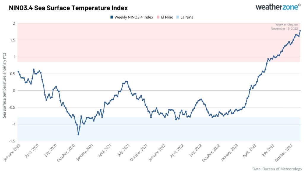
Image: Weekly Niño-3.4 temperature anomaly since January 2020.
The event should intensify further in January next year, making it likely that the event will continue into Autumn 2024.
The graph below shows that the U.S. Climate Prediction Center (CPC) and Columbia University’s International Research Institute for Climate and Society (IRI) is predicting an 88% chance of El Niño in Autumn.
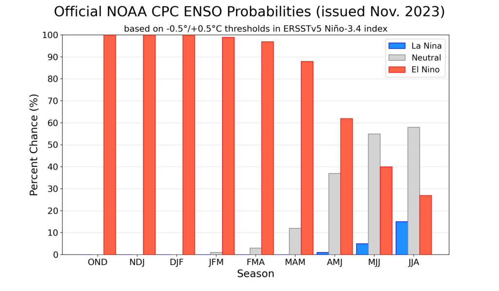
Images U.S. Climate Prediction Center (CPC) and Columbia University’s International Research Institute for Climate and Society (IRI) Niño-3.4 Sea surface temperature anomaly forecasts.
The institute also forecasts that El Niño will most likely end sometime in May or June 2024, meaning that the unusually warm and dry conditions will continue through until mid-next year.
The maps below show the unusually warm and dry outlook for parts of the country in April 2024.
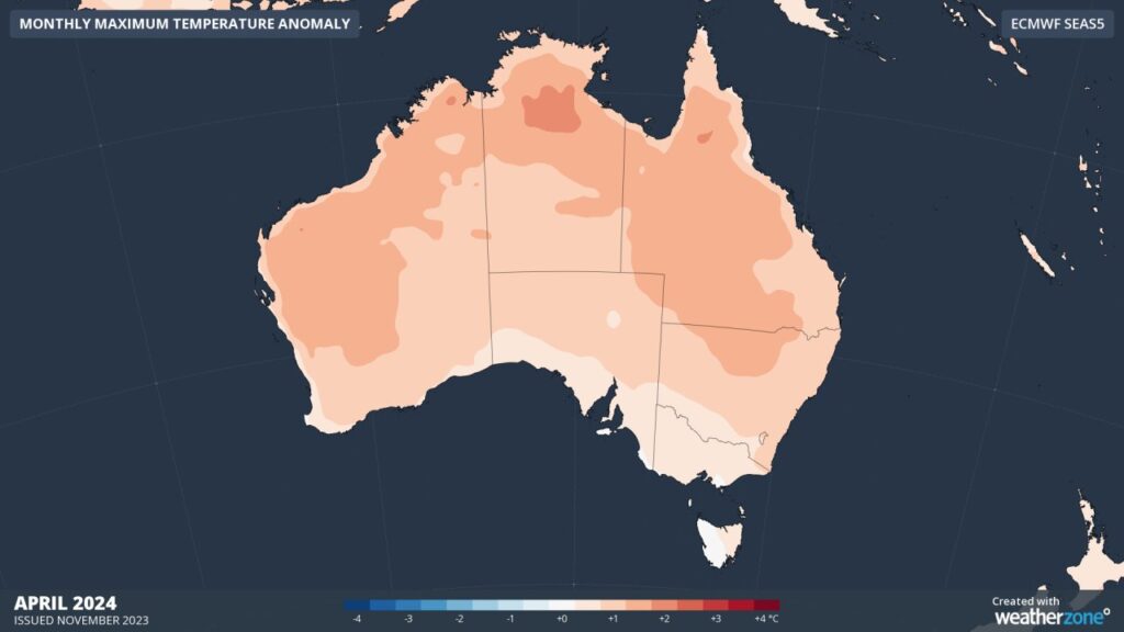
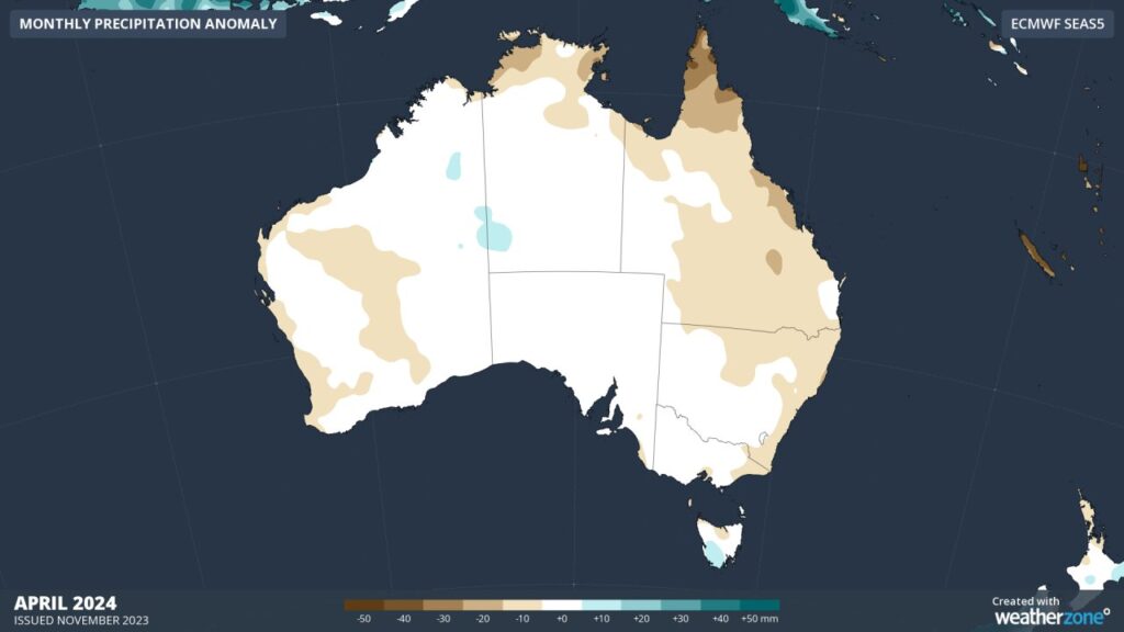
Images: Temperature (top) and rainfall (bottom) forecast anomalies for April 2024.
To the west of Australia, a positive Indian Ocean Dipole (IOD) remains underway, which is another dry phase climate driver impact Australia this spring and potentially early summer.
This week, the IOD index was 1.49ºC which has weakened in the past month after peaking in mid-October at 1.92ºC.
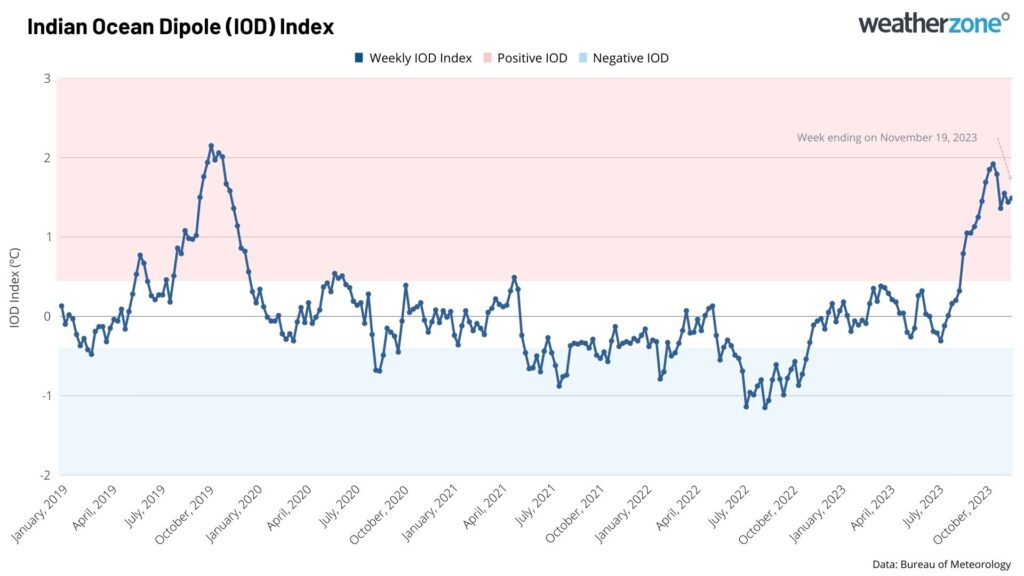
Image: Weekly IOD temperature anomaly since January 2020.
The 2023 positive IOD event is the second strongest recorded since weekly records began in 2001. The record was set during 2019, which reached +2.15ºC and led to the second warmest summer on record for Australia.
While the IOD is typically a spring like phenomenon, breaking down upon the arrival of the monsoon trough around December, this year it could last a little longer.
Current model data suggests that the positive IOD should ease in December or January, with the onset of the monsoon expected to be delayed under the influence of El Niño.
The positive IOD in spring like El Niño brings warmer and drier weather to much of Australia as it does in summer but to a lesser extent.
Despite the two dry-phase climate drivers influencing Australia this spring, the east coast has seen an increase in rain, cloud and thunderstorm activity in recent weeks.
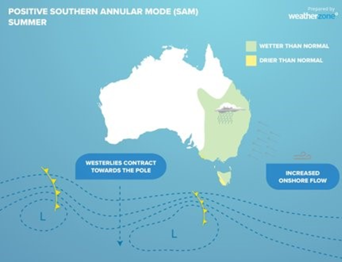
A positive phase of the Southern Annular Mode (SAM) has been responsible in recent weeks for the taps turning on.
The Southern Annular Mode refers to the north or south displacement of the westerly frontal belt that moves across southern Australia. The image below shows that when it is positive it can increase rainfall cloud and humidity along the eastern seaboard.
The recent weeks have demonstrated that El Niño is not the only climate drivers at play this spring.
For more information on our climate presentations which give a detailed analysis of the weather in the coming months, please contact us at apac.sales@dtn.com.




