
Australia is being warned to prepare for an unusually warm and dry spring, despite the Bureau of Meteorology continuing to hold back on declaring a fully-fledged El Niño.
The Bureau released its latest climate driver update on Tuesday afternoon, stating that “Sea surface temperatures (SSTs) in the tropical Pacific are exceeding El Niño thresholds”.
However, the Bureau also pointed out that “overall, atmospheric indicators suggest the Pacific Ocean and atmosphere are not yet consistently reinforcing each other, as occurs during El Niño events.”
By failing to declare an El Niño on Tuesday, the Bureau’s alert system for the El Niño-Southern Oscillation remains at El Niño Alert for the 8th consecutive week. This means there is a 70 percent chance of El Niño being declared later this year.
The Bureau’s position on El Niño goes against other global climate monitoring organisations that declared El Niño as being underway in June and July, including the World Meteorological Organization, the U.S. National Oceanic and Atmospheric Administration, and the Japan Meteorological Agency.
The Bureau’s hesitation to declare El Niño in recent weeks has been due to the atmosphere above the tropical Pacific Ocean being reluctant to shift into an El Niño-like pattern, despite the underlying ocean being in a clear El Niño state.
What does this mean for Australia’s weather?
While El Niño has not yet been declared by the Bureau, the Pacific Ocean is still in an El Niño-like pattern, and this should still have some influence on Australia’s weather in the coming weeks and months.
- El Niño typically causes below-average rain over large areas of Australia, particularly in northern and eastern parts of the country.
- It also promotes above-average daytime temperatures over most of Australia.
- While days are usually warmer during El Niño, clearer nights (less cloud) often cause an increased frost risk during winter and spring.
- El Niño often means reduced winter snow depths in Australia’s alpine region.
- El Niño can also increase fire danger in parts of the county, especially southeastern Australia.
It’s also important to note that El Niño may not be the only broad-scale climate driver influencing Australia’s weather in the coming months.
A number of forecast models suggest that a positive Indian Ocean Dipole (IOD) will develop to the northwest of Australia this spring. Much like El Niño, a positive IOD reduces the likelihood of rainfall and increases daytime temperatures in Australia.
When a positive IOD and El Niño occur at the same time, their combined influence usually reinforces the dry and warm influence on Australian weather.
You can see the warm and dry influence of a potential El Niño and positive IOD in the seasonal outlooks below. Most of Australia is expected to see near-to-below average rainfall this spring, while the whole county has a good chance of experiencing a warmer than average spring based on maximum temperatures.
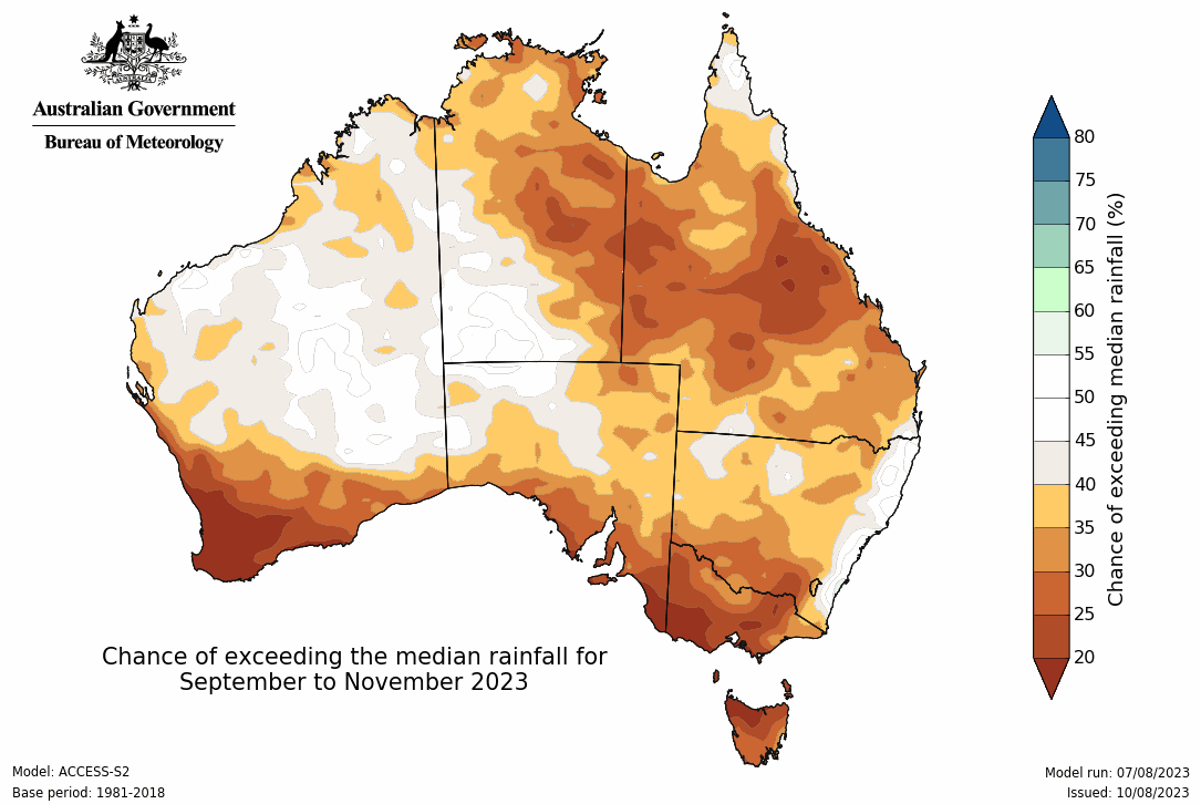
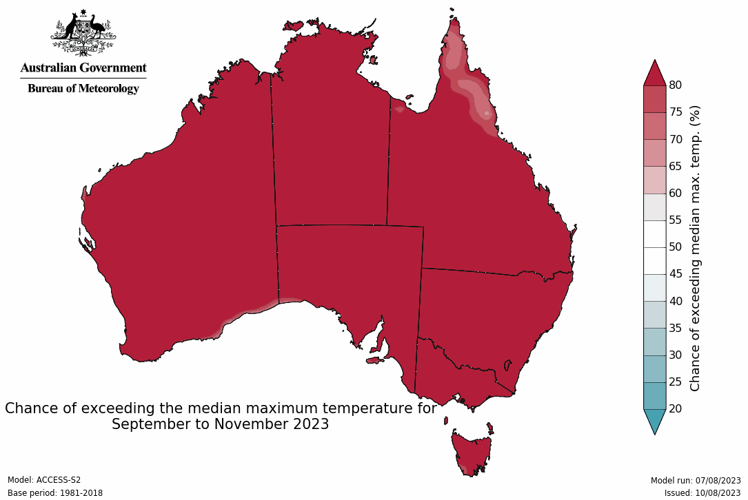
Images: Spring outlooks for rainfall (top) and maximum temperatures (bottom) in Australia. Source: Bureau of Meteorology




