

Australia’s Bureau of Meteorology is digging its heels into the sand and defying the World Meteorological Organization by announcing today that El Niño is not currently underway.
The World Meteorological Organization issued a statement on July 4 declaring that El Niño conditions had developed in the Pacific Ocean for the first time in seven years.
The WMO’s El Niño declaration came roughly one month after the U.S. Climate Prediction Center announced El Niño’s arrival, issuing an El Niño Advisory on June 8.
While Australia’s Bureau of Meteorology agrees that the tropical Pacific Ocean is in a clear El Niño-like pattern, they aren’t yet ready to join the WMO and CPC in officially declaring El Niño.
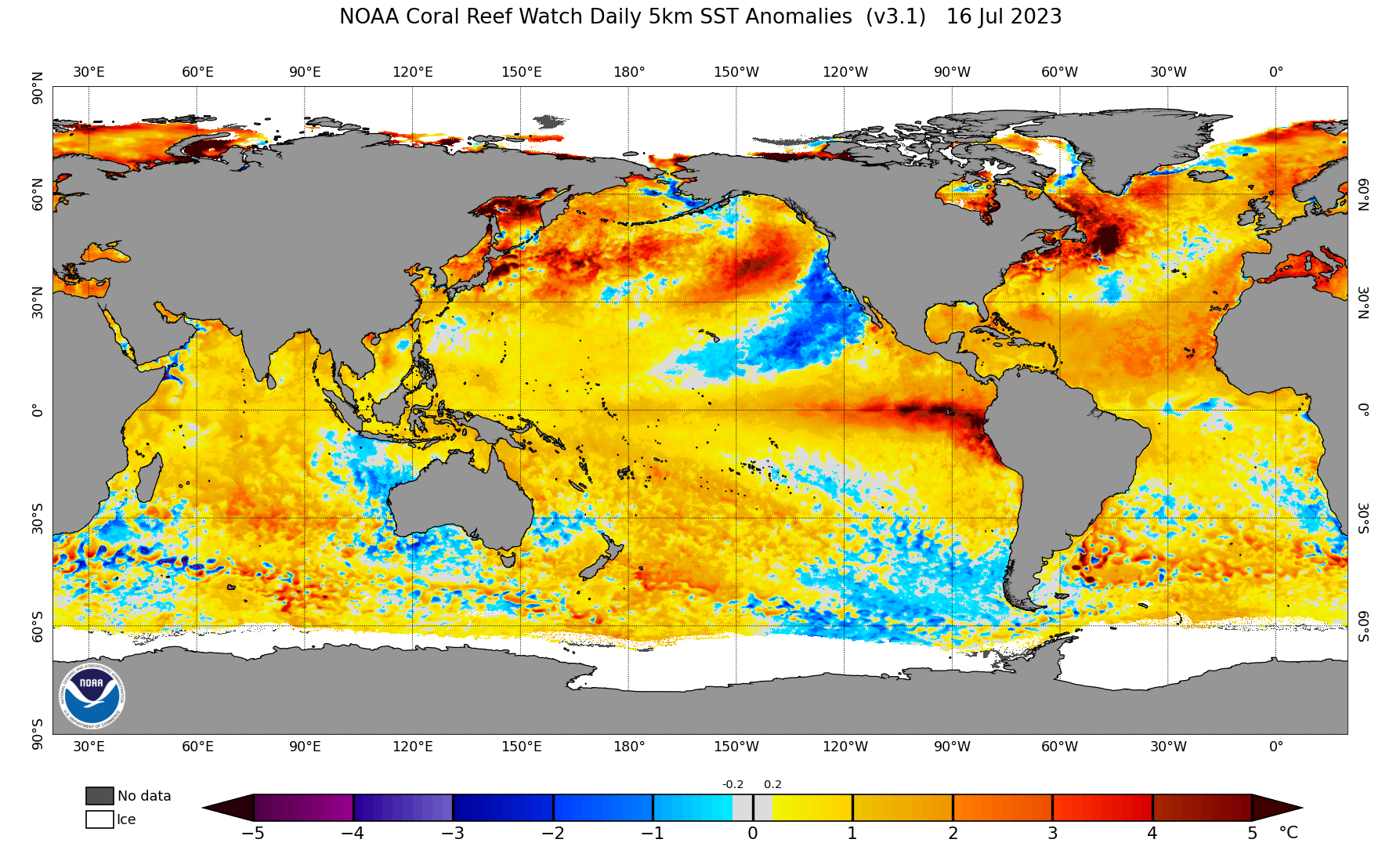
Image: Global sea surface temperature anomalies on July 16, showing a large tongue of abnormally warm water in the central and eastern tropical Pacific Ocean, a key component of El Niño. Source: NOAA
In its latest climate driver update issued on Tuesday afternoon, the Bureau stated that “the Pacific Ocean and atmosphere have yet to become fully coupled”, and “the ENSO Outlook remains at El Niño Alert.”
The Bureau reluctance to declare El Niño stems from the atmosphere refusing to respond to the abnormally warm waters sitting at the surface of the central and eastern tropical Pacific Ocean. This ‘coupling’ of the tropical Pacific Ocean and the overlying atmosphere are a critical part of El Niño and its associated impacts.
.png)
Image: The Bureau retained an El Niño alert in its latest climate driver update, issued on July 18, 2023. Source: BoM
For the Bureau of Meteorology to declare El Niño, any three of the following four criteria need to be met:
- Sea surface temperature: Temperatures in the NINO3 or NINO3.4 regions of the Pacific Ocean are 0.8 °C warmer than average.
- Winds: Trade winds have been weaker than average in the western or central equatorial Pacific Ocean during any three of the last four months.
- SOI: The three-month average Southern Oscillation Index (SOI) is –7 or lower.
- Models: A majority of surveyed climate models show sustained warming to at least 0.8 °C above average in the NINO3 or NINO3.4 regions of the Pacific Ocean until the end of the year.
While the first and fourth conditions from the list above have been satisfied, the atmospheric components (two and three) are yet to be met.
A good reason for this reluctance is that Australia is more responsive to the atmospheric component of El Niño than most other nations. Furthermore, the SOI compares the relative pressure difference between Tahiti and Darwin. Therefore, when the SOI is in a persistent negative value, we know that El Niño is actively suppressing the atmosphere and rainfall over Darwin, and by extension, Australia as a whole.
With most international climate monitoring organisations already declaring the onset of El Niño, and the ocean component of the phenomenon already firmly in place, it’s likely the Bureau will declare El Niño later this year. However, the atmosphere needs to get a move on for this to happen.
You can find out what El Niño means for Australian weather in our El Nino Guide: What is El Nino and how does it affect Australia?
DTN APAC has a variety of forecasting and alerting tools on hand to help your business cope with the challenges that an El Niño can bring. For example, with the increase in bushfire risk, our hotspot detection will alert you to nearby fires (even small ones) so you can take action to protect your personnel and assets. To find out more please visit our website or email us at apac.sales@dtn.com.




