
August 2024 across Australia was the warmest on record by a considerable margin, with a mean average temperature that was 3.02°C above the long-term average, while the 2024 winter was the second-warmest on record nationwide.
That’s an entire month that was three degrees warmer than average when you factor in both minimum and maximum temps at over 100 Australian weather stations across each state and territory.
The graph below paints a dramatic picture and points strongly to the underlying influence of climate change, with only two years in the last 30 not exceeding average temps nationwide in August.
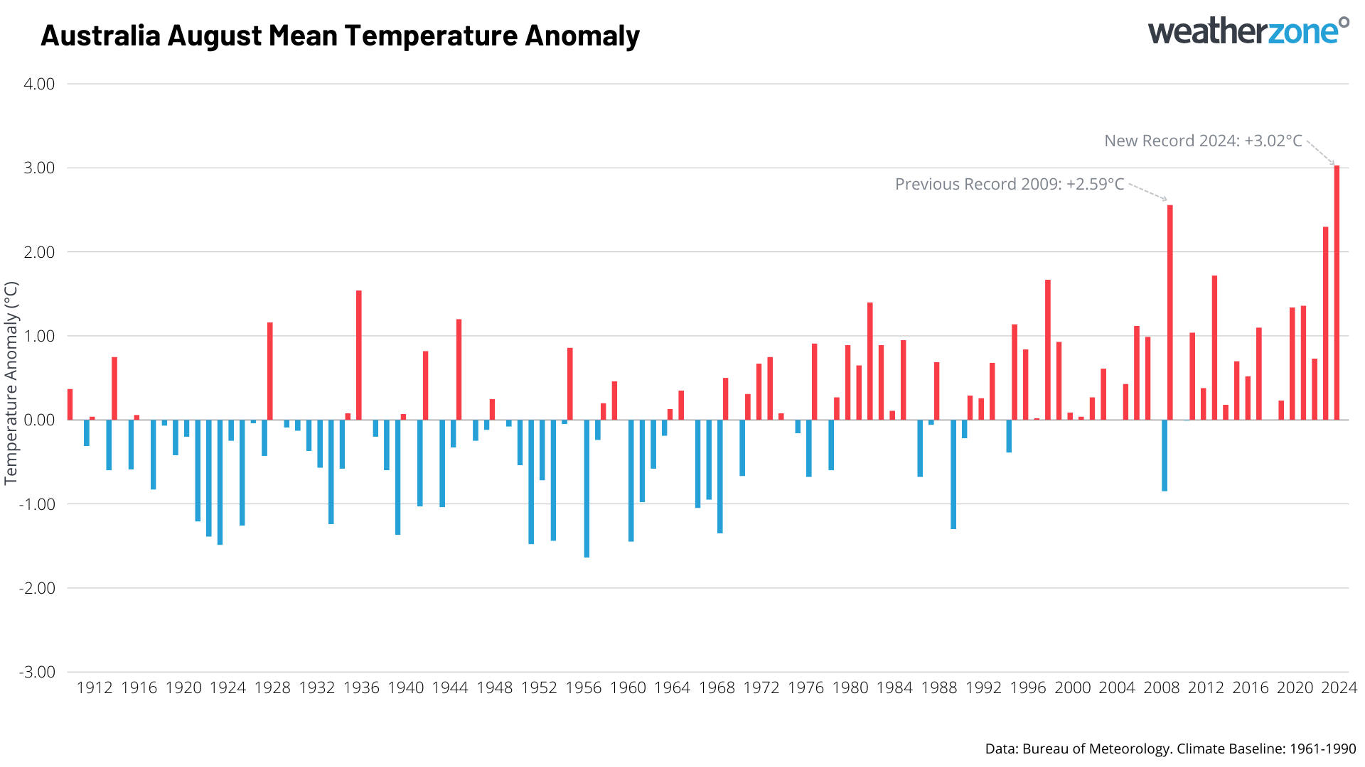
Image: August temperature anomalies by year compared to the period from 1961-1990. The international meteorological standard is to use a 30-year period.
Australia has never recorded a winter month anywhere near as warm as August 2024. This statistic will come as no surprise to most Australians, the majority of whom experienced unseasonable warmth in their area.
For example:
- All eight capital cities were much warmer than average both by day and by night in August 2024.
- Australia recorded its hottest winter day on record, with 41.6°C at Yampi Sound in northwest WA. The popular holiday spot of Broome, also in northwest WA, reached 40.5°C, which was its first winter day over 40°C.
- Queensland registered its hottest winter day on record, with the mercury falling just shy of 40°C at Birdsville.
- Sydney experienced an extraordinary run of winter warmth to close out August, with the last 11 days all reaching max temps which were at least five degrees above the August average. The heat peaked on August 30, with Sydney registering just its third 30-degree winter day on record (30.3°C), while Sydney Airport broke its winter record with a top of 31.6°C.
- Canberra’s average August maximum of 16.7°C was 3.7°C above the long-term average.
- Numerous places in Western Australian experienced their warmest winter on record, including many locations in southwest WA which was unusual as they were also wetter than average – and clouds and wet weather usually tend to keep daytime temperatures down.
- Snow depths in mainland Australia’s alpine areas plunged to near-record lows for August, as a promising ski season was virtually wiped out by warm air, wind and rain in the last two weeks of the month.
Why was August so warm?
Apart from the underlying influence of the warming climate mentioned above, August was a month when the cold fronts which bring rain, hail, snow and bitterly cold air to southern mainland Australia were largely absent, with high pressure dominating the country.
There was also an extraordinary build-up of heat in the interior of the country late in the month. This shows up strongly on the chart below.
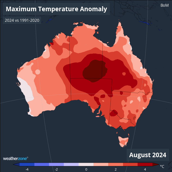
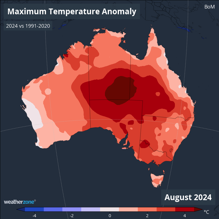
Image: Mean temperature anomalies (difference compared to the long-term average) Australia-wide in August 2024.
- What’s remarkable about the above chart is not just the dramatic red blobs in the centre of the country, but that the whole of Australia was warmer than normal.
- This wasn’t a case of cool here, warm there, but warmer overall when you average it out.
- Every single region of Australia was at least a degree warmer than the monthly average in August 2024, and that figure rose to almost six degrees in the interior (where Alice Springs had its warmest winter day on record, with its hottest day of 36.6°C exceeding the monthly average for January, the hottest month).
What about winter as a whole across Australia (not just August)?
As mentioned, it was Australia’s second-warmest winter, just falling short of the 2023 winter but not by much.
While national mean temps were around 0.7°C above average in both June and July 2024, the warmth in those months was nowhere as extreme as August, which meant the exceptionally warm winter of 2023 remains Australia’s warmest on record.
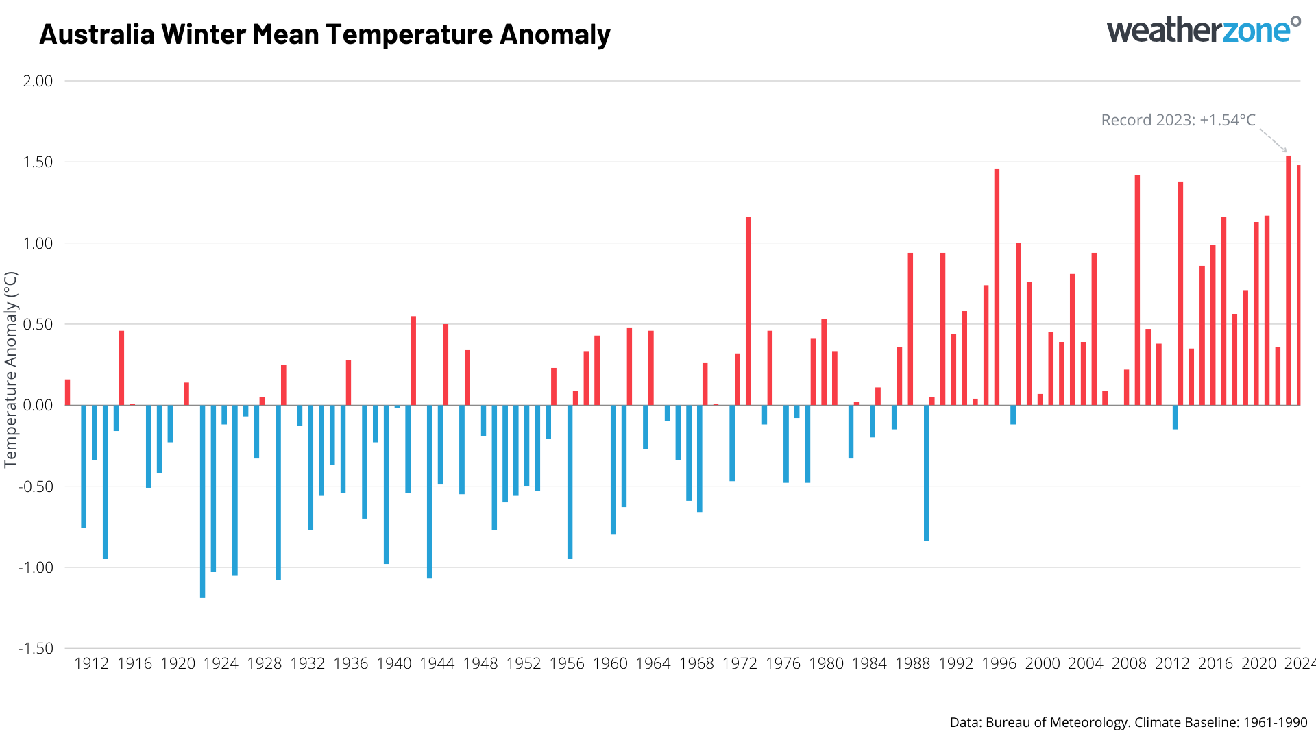
Image: Winter temperature anomalies by year compared to the period from 1961-1990.
- The winter of 2023 was 1.54°C above the long-term average.
- The winter of 2024 was 1.48°C above the long-term average.
And because the weather gods hgave a sense of humour, an exceptionally cold airmass is currently moving through southeastern Australia this Monday, bringing snow to the mountains and a frigid day to Melbourne, which was just 8.4°C at 1 pm.
The cold outbreak will be relatively short-lived and Melbourne should reach 20°C by Wednesday afternoon.
he shifting climate is bringing increased complexity and greater risks to businesses worldwide. We are here for you, delivering trusted weather solutions to optimize your operations and profitability.
DTN APAC is a diverse team, with global forecasting, product development and analytics expertise. Couple this with extensive industry experience spanning Aviation to Energy, and we are primed to assist you in strengthening your response to weather
impact.
We work hard to identify your operational pressures and tailor our services and products to meet your needs. Concise communication, giving you full situational awareness exactly when you need it, is our focus. We want to reduce weather risk in your operations, every day.
We deliver clear and comprehensive weather data, personalised risk assessments and briefings to you and your team, so that your critical decisions can be made with confidence.
We are available 365 days a year, so you always have the timely guidance you require, especially when severe conditions hit.
You have our insights to rely on to see you through complex situations, minimising potential loss of profit and maximising the safety of your staff and assets. For more information, please visit our website or email us at apac.sales@dtn.com.




