
El Niño and the typically drier-than-usual weather it brings across much of Australia is now officially one step closer after the BoM issued an El Niño Alert this Tuesday, June 6.
“The Bureau’s *ENSO [El Niño Southern Oscillation] Outlook has been shifted to El Niño ALERT, indicating a 70% chance of El Niño forming this year,” The BoM said on Tuesday afternoon. “This equates to roughly three times the normal chance of an El Niño forming.”
While an official Alert does not definitely mean El Niño will be declared in 2023, it indicates a significantly elevated likelihood, and it’s an upgrade from the previous state of “El Nino Watch” which simply meant an increased risk of an El Niño occurring compared to most years.
What is El Niño again?
- In short, it’s a shift in water temperatures and winds in the central and eastern tropical Pacific Ocean that affects weather in numerous ways both in Australia and elsewhere.
- Both El Niño and La Niña are examples of climate drivers – broad-scale climatic patterns which influence our day-to-day weather.
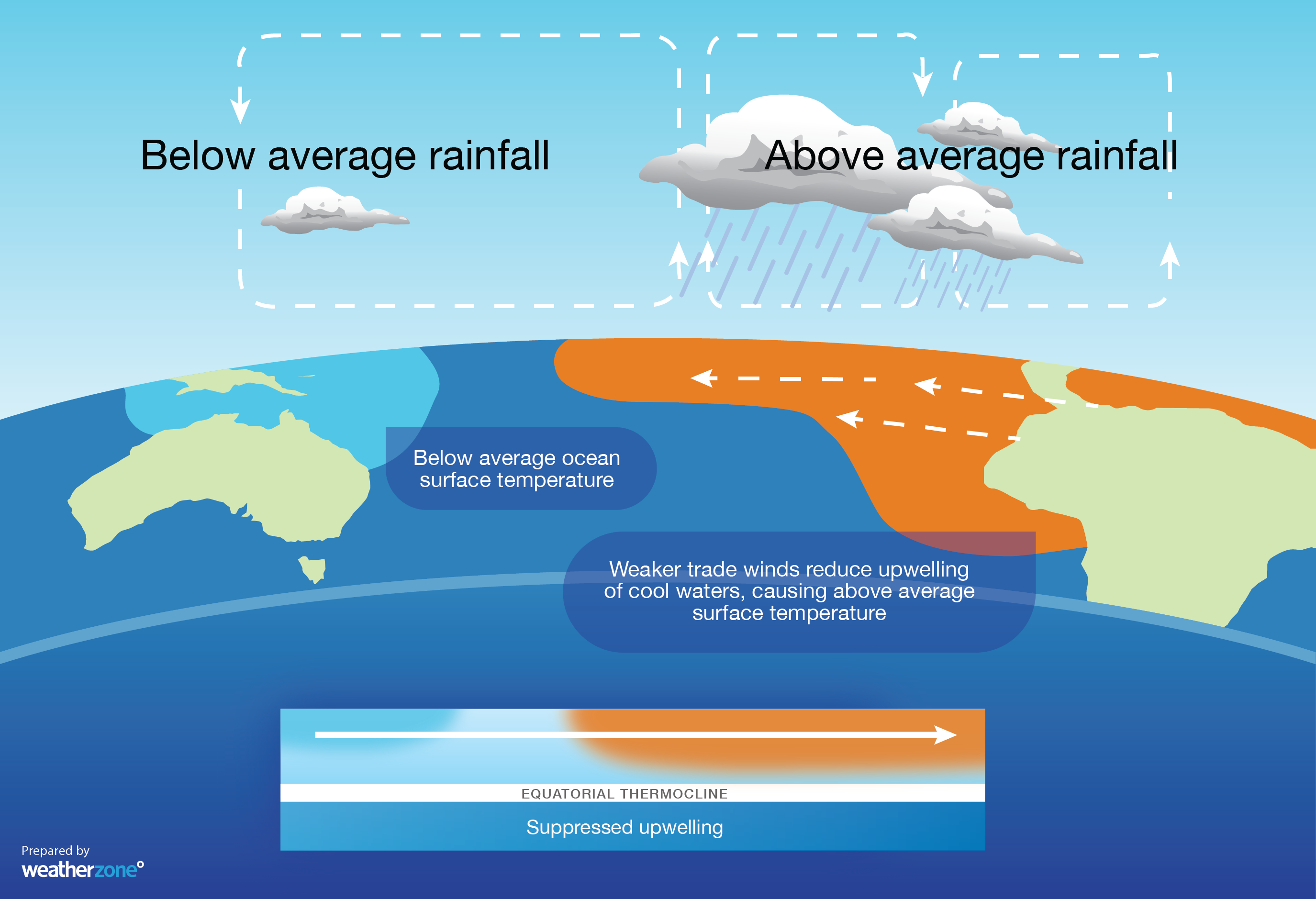
- El Niño is associated with a sustained period of warming in the central and eastern tropical Pacific Ocean, while La Niña is associated with a cooling of waters in that region. Both events are associated with shifts in broad-scale wind patterns, which in turn affect our weather.
- El Niño causes a weakening or reversal of the direction of the trade winds in the tropical Pacific. This atmospheric shift decreases the development of cloud that leads to heavy rainfall to the north of Australia. This then affects Australia’s weather more broadly.
- You might also hear the term “ENSO” this week. It simply means the “El Niño-Southern Oscillation” and it’s a term that describes the wavering between El Niño and La Niña states in the Pacific region.
How does El Niño typically affect Australia?
- El Niño typically causes below-average rain over large areas of Australia
- It also typically causes above-average daytime temperatures
- While days are usually warmer, clearer nights often cause an increased risk of frost during winter and spring
- El Niño often means reduced winter snow depths in our southern alpine region
- El Niño can also increase fire danger in parts of the county
- It often means a late onset of the monsoon (which feeds our tropical wet season) and can also reduce tropical cyclone activity in the Australian region
How do we know that El Niño is probably on its way?
As Weatherzone meteorologist Ben Domensino explained recently, the BoM uses both observations and forecasts from several oceanic and atmospheric indicators to monitor whether El Niño, La Niña or neutral conditions are present in the Pacific Ocean.
We’d urge you to read his story in full, but the super quick version is that the BoM looks at sea surface temps, winds, climate models and the Southern Oscillation Index (SOI).
The (SOI) at present is particularly relevant. See the massive dip on the graph below?
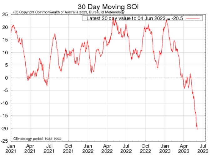
Image: The most recently available SOI 30-day average, ending June 4, reached a level of -9.3 Source: BoM.
For the record, the SOI measures the atmospheric pressure difference between Tahiti and Darwin. But what you really need to know is that it dropped below -7 on May 16 and continues to plummet.
Why is a plummeting SOI significant?
Because a SOI level of -7 El is the Niño threshold, and May 16 was the first time the 30-day SOI index had reached the threshold of -7 since mid-2020.
Due to the variable nature of the SOI signal, negative values of -7 or lower need to be sustained for around three months before the Bureau officially declares El Niño. We’re not there yet. But we’re getting a lot closer, and today’s El Niño alert was issued after the SOI index had been at -7 or lower for two months.
DTN APAC has a variety of forecasting and alerting tools on hand to help your business cope with the challenges that an El Niño can bring. For example, with the increase in bushfire risk, our hotspot detection will alert you to nearby fires (even small ones) so you can take action to protect your personnel and assets. To find out more please visit our website or email us at apac.sales@dtn.com.




