

The World Meteorological Organization has confirmed that 2023 was an astonishing year for our planet’s climate, with records obliterated in the atmosphere, hydrosphere and cryosphere.
Atmosphere
Global air temperatures frequently made headlines around the world in 2023 as records fell month after month.
Every calendar month from June to December set a new global average near-surface air temperature record for that time of year.
This string of exceptional warmth in the second half of 2023 pushed the annual global mean air temperature to 1.45°C (±?0.12?°C) above the 1850 to 1900 pre-industrial baseline. According to the WMO, this was the highest annual mean temperature on record, beating the previous record from 2016 by 0.16ºC.
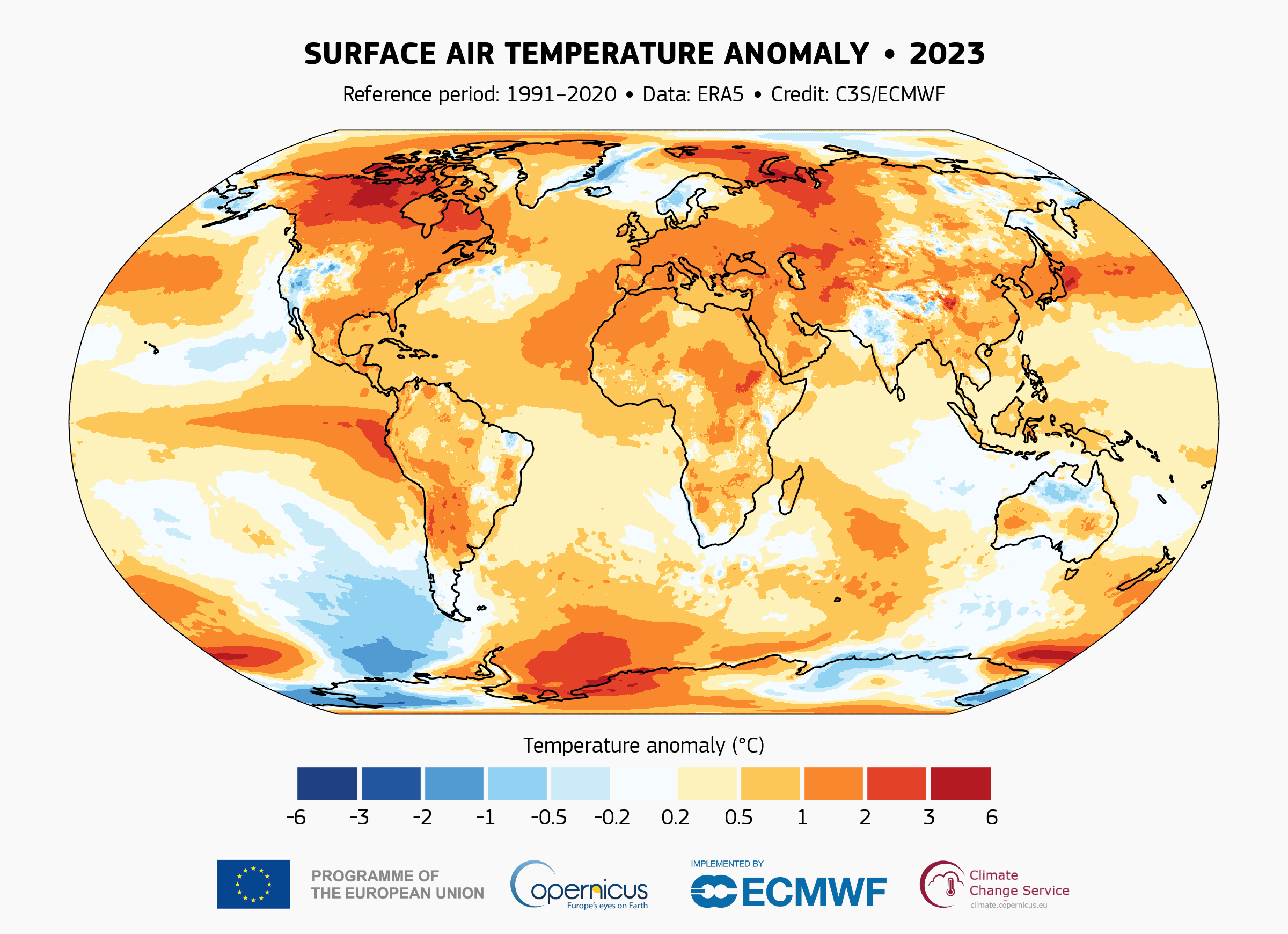
Image: Surface air temperature anomaly in 2023, based on the ERA5 dataset. Source: Copernicus Climate Change Service.
Oceans
The record warmth in Earth’s atmosphere last year was also mirrored in the oceans, with global sea surface temperatures reaching record-breaking levels from March onwards.
Every month from April to December set a new respective monthly record in 2023, while a new daily sea surface temperature record was observed in August (note that this has since been exceeded in 2024).
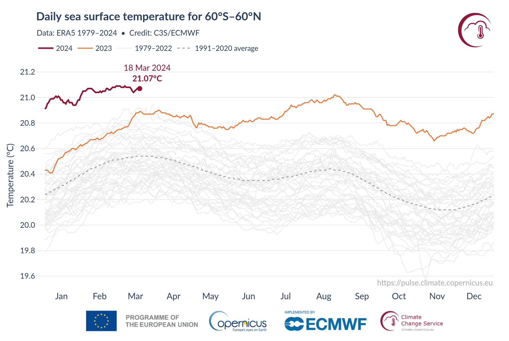
Image: Daily global sea surface temperatures between 1979 and 2024 to date, based on the ERA5 dataset. Source: Copernicus Climate Change Service
The global mean sea level also reached a new record height in 2023, driven by abnormal ocean warmth and increased melting of glaciers and ice sheets.
According to the WMO, “the rate of global mean sea level rise in the past ten years (2014–2023) is more than twice the rate of sea level rise in the first decade of the satellite record (1993–2002).”
Ice
Parts of the cryosphere – the frozen portions of our planet – also broke records in 2023.
Antarctic sea-ice extent reached record lows for the seasonal minimum extent in February and maximum extent in September.
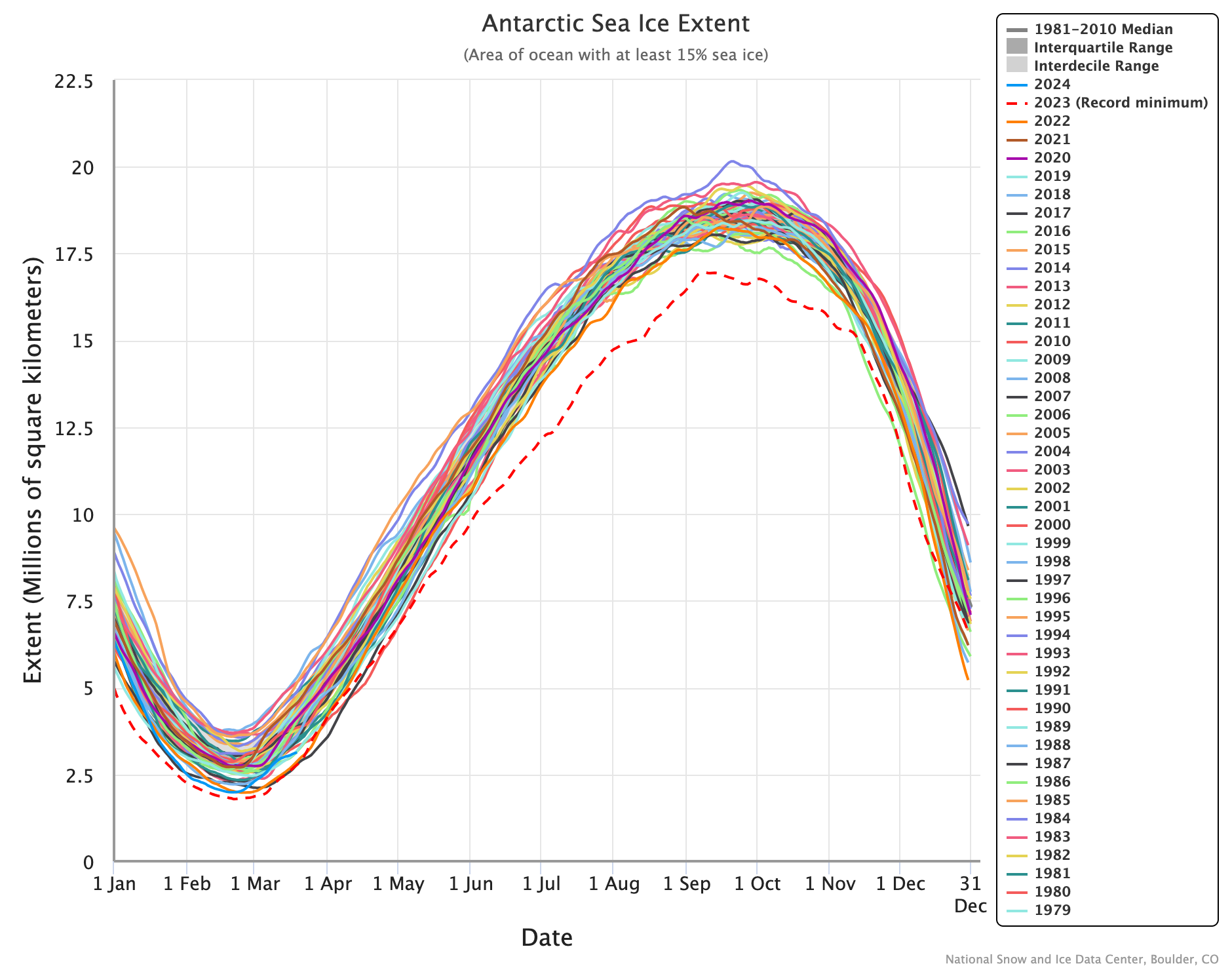
Image: Antarctic sea ice extent between 1979 and 2024 to date, showing record-breaking low sea ice extent in 2023 (dashed line). Source: NSIDC
Glacier melt was also pushed to new levels in 2023. According to the WMO, “preliminary data from the global set of reference glaciers for the hydrological year 2022-2023 show they experienced the largest loss of ice on record.”
What made 2023 so warm?
Climate change and El Niño were both contributing factors to the record-breaking warmth in 2023. However, these drivers alone aren’t enough to account for the magnitude of last year’s abnormal warmth.
According to the Copernicus Climate Change Service, other influences that may have contributed to the exceptional state of the climate in 2023 are:
- Enhanced stratospheric water vapour due to the eruption in January 2022 of the Hunga Tonga–Hunga Ha’apai volcano
- Reduced aerosols due to lower sulphur dioxide emissions by shipping
- The approach of the current solar cycle to its peak.
These influences are still an active topic of research and may continue to influence Earth’s global climate system in 2024. Monitoring Earth’s global climate system is an essential part of understanding how the climate is changing and what steps need to be taken, now and in the future, to mitigate its effects.
You can’t control the shifting climate, but you can gain precision insights to optimise your response. DTN APAC, a DTN company, has been providing weather intelligence and innovative forecasting systems to Australian businesses since 1998.
We have intuitive solutions that serve industries from aviation, mining and energy right through to marine, and everything in between. Rest assured, if we don’t already have a product to address your business’ weather needs, we will work tirelessly to create one. For more information, please contact us at apac.sales@dtn.com.




