Global climate records have been shattered in 2023, with temperatures in the atmosphere and ocean at the warmest levels ever observed, according to a new report.
The World Meteorological Organization (WMO) released a provisional State of the Global Climate report on November 30 to coincide with the start of the COP28 United Nations Climate Change conference in Dubai.
While the WMO’s final State of the Global Climate 2023 report will come out in 2024, this week’s report provides an interim update on the state of the global climate to inform discussions at COP28. Below are some of the key points from the report:
Greenhouse gases
The global average temperature has been gradually increasing in recent decades, primarily in response to increasing concentrations of atmospheric greenhouse gases from human activities.
These global greenhouse gases continue to increase, with the concentrations of carbon dioxide, methane and nitrous oxide observed reaching record high levels in 2022. These greenhouse gas concentrations have continued to rise this year, contributing to the record-breaking warmth across the globe.
Atmospheric temperature
This year is on track to be the world’s warmest year on record, with new data from the WMO showing that the mean near-surface temperature so far in 2023 (January to October) was 1.4°C warmer than the pre-industrial average (between 1850-1900). The size of this anomaly up to October means 2023 is virtually certain to be the planet’s warmest year in 174 years of records.
The map below shows that the ten years leading up to 2023 (as of October) have been the warmest 10-year period on record.
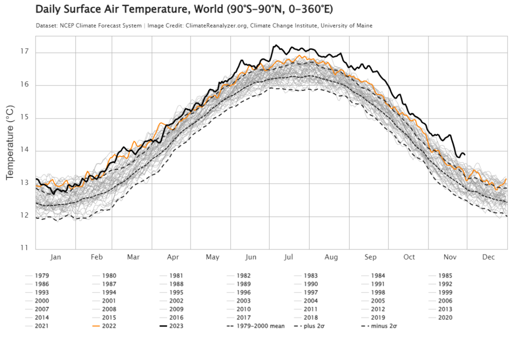
Image: World Daily surface air temperature since 1979 showing 2023 (black) and 2022 (orange) and previous years (grey), Source: climatereanalyzer.org ,Climate change institute, University of Maine
This year’s global mean temperature should comfortably beat the joint warmest years on record, which were 2016 and 2020.
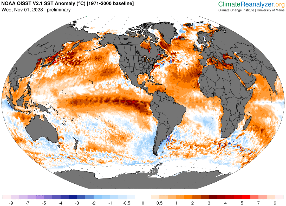
The ocean heat in 2022 reached its highest level since records began 65 years ago. The black line below shows the 2023 Sea Surface Temperatures (SSTs) have been tracking above the previous record for most of the year.
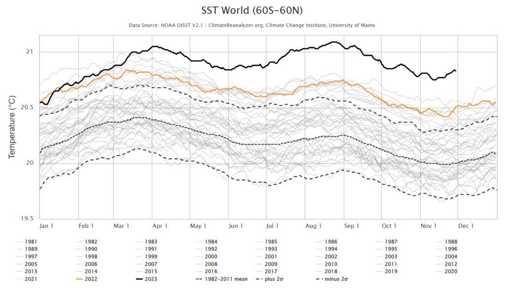
Image: World Daily Sea Surface temperature since 1981, showing 2023 (black) and 2022 (orange) and previous years (grey), Source: climatereanalyzer.org ,Climate change institute, University of Maine
The ocean covers around 70% of the Earth’s surface and absorbs heat and greenhouse gases. While the absorption of heat in the ocean can slow the warming of the atmosphere, the warming oceans have increased the sea level and ice melt significantly.
Sea Ice
Antartica has seen record low sea ice extent since satellites began observing the ice in 1979.
The images below shows that on Wednesday, November 29, the Antarctic and Artic Sea Ice extent is much lower than the median ice edge from the 1981 to 2010 period.
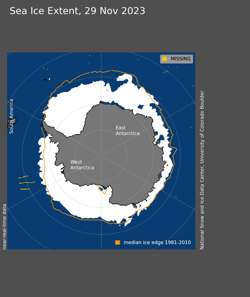
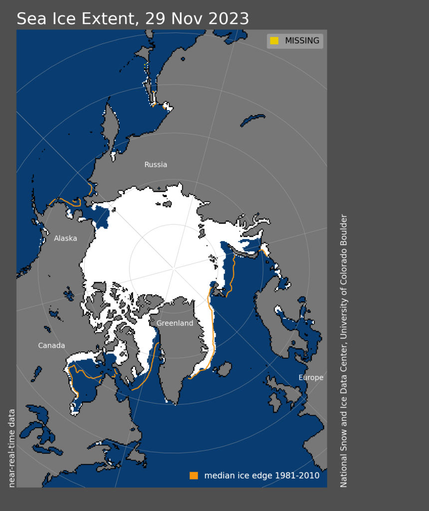
Images: Antarctic (top) and Artic (bottom) daily sea ice extent, showing ice (white shade) and the 1981 to 2010 average extent (orange) Source: National Snow and Ice Data Centre
It was also reported that the glaciers in western North America, the European Alps and Switzerland have all experienced extreme melt.
Sea level rise
The melting of glaciers and ice sheets has meant that the global mean sea level in 2023 reached a record high for the satellite era, which because in 1979. The rate of sea level rise has doubled in the past decade compared to the decade between 1993 and 2003.
Extreme weather
The WMO’s report also mentioned the extreme weather that has impacted many areas of the world in 2023:
- Extreme heat has affected many parts of the world, including record-breaking heatwaves in Europe in July and August
- Wildfires in Hawaii, Canada and Europe
- Flooding in Greece, Bulgaria, Türkiye, and Libya
The WMO’s full report will come out in the first half of next year.
Are you protecting your enterprise from the increasingly volatile weather risk?
You can’t control the shifting climate, but you can gain precision insights to optimise your response.
DTN APAC, a DTN company, has been providing weather intelligence and innovative forecasting systems to Australian businesses since 1998.
We have intuitive solutions that serve industries from aviation, mining and energy right through to marine, and everything in between. Rest assured, if we don’t already have a product to address your business’ weather needs, we will work tirelessly to create one.
With our network of global partners, we provide trusted, industry-leading services that can mitigate weather risk, keep your valuable staff and assets safe, and ensure you are operating at peak efficiency. For more information, please contact us at apac.sales@dtn.com.


