
Large areas of Australia have just experienced one of their warmest starts to winter on record as global air and ocean temperatures surge to unprecedented levels for this time of year.
The first fortnight of winter 2023 has featured some unseasonably warm temperatures in Australia. The maps below show how daily maximum temperatures have compared to the long-term average on each of the first 12 days in June. Red and orange areas show where temperatures have been warmer than average, while green and blue are cooler-than-average.
A lack of strong cold fronts during the last couple of weeks has allowed unusually warm air to linger over Australia, particularly in central, southern and eastern parts of the country. This warm air has taken the usual bite out of the start of winter and hindered the buildup of early-season snow in the Alps.
The map below shows a crude estimate of the 850 hPa temperature anomaly over Australia during the first 11 days of the month combined. The large red blob over the Australian Interior shows that temperature around 1.5 km above central Australia have been running more than three degrees above average in the first half of June.
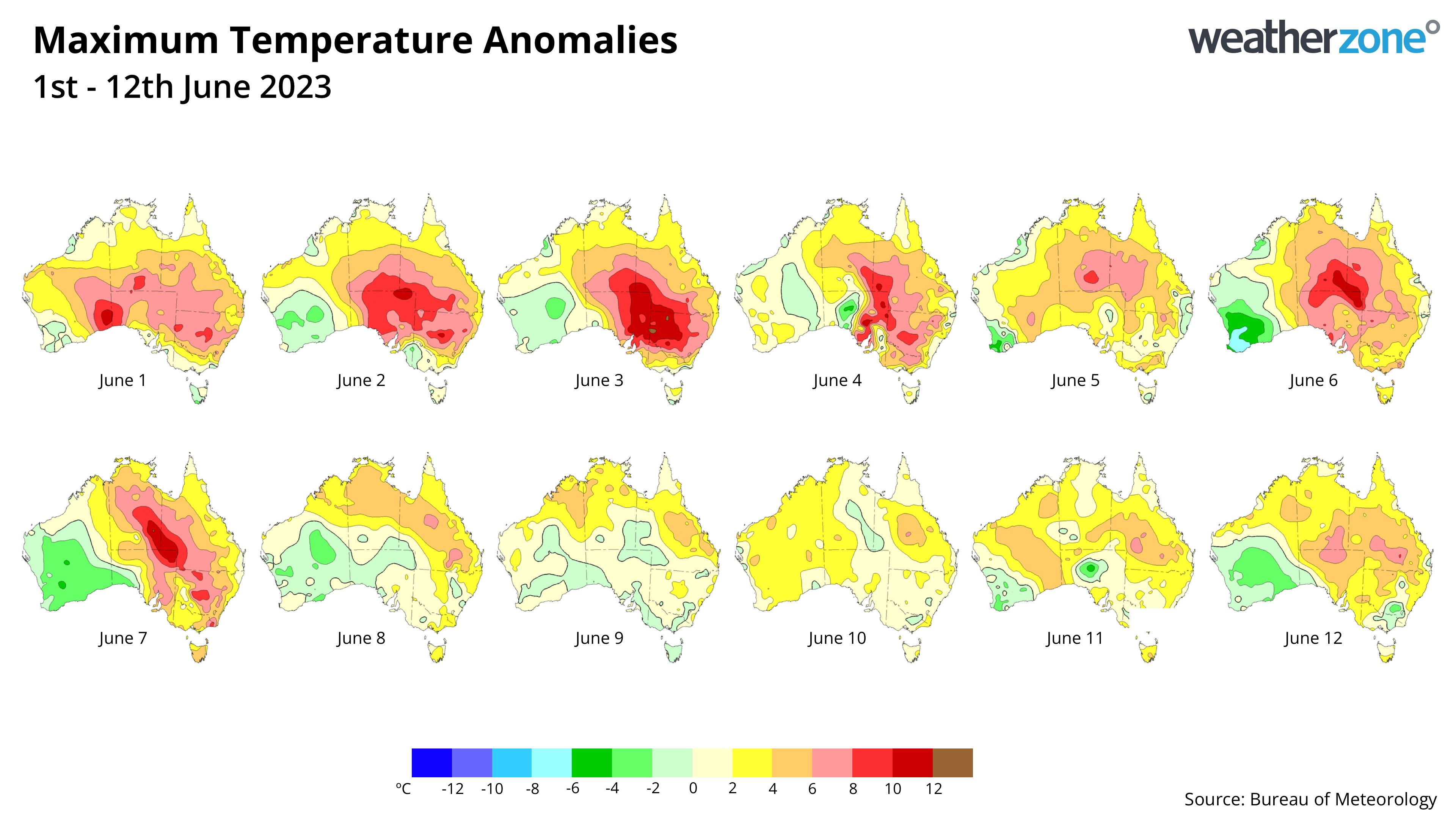
Image: 850 hPa temperature anomaly during the first 11 days of June 2023. Source: NOAA / NCAR
Some standout statistics from the opening fortnight of winter:
- The average maximum temperature in Alice Springs, NT during the first 14 days of June has been around 24.3ºC. Based on daytime warmth, this is the 4th warmest first fortnight of winter in records dating back to 1878.
- The mean maximum temperature at Longreach, Qld during the first 14 days of June was 28.6ºC. This is 5ºC above average and its warmest start to winter in records dating back to 1897.
- Charleville’s (Qld) mean maximum temperature in the first 14 days of June was around 25.2ºC. This is 5ºC above the long-term June average and Charleville’s 2nd warmest first fortnight of winter in 135 years of records.
- In SA, Adelaide’s mean temperature (minimums and maximums combined) during the first 14 days of winter has been around 16.1ºC. This is four above average and the city’s 2nd warmest start to winter in records dating back to 1887.
- In Melbourne, Vic the average minimum temperature during the first 14 days of June was 10ºC, making this the city’s 6th warmest start to winter in 169 years of records.
Exceptional global warmth
Australia’s unusually warm start to winter has occurred against a backdrop of unprecedented global warmth.
The two graphs below show annual air and ocean surface temperature anomalies during the past four decades, with the black line representing 2023 to date. The graphs show that our planet’s air and ocean temperatures are both currently running at record high levels for this time of year.
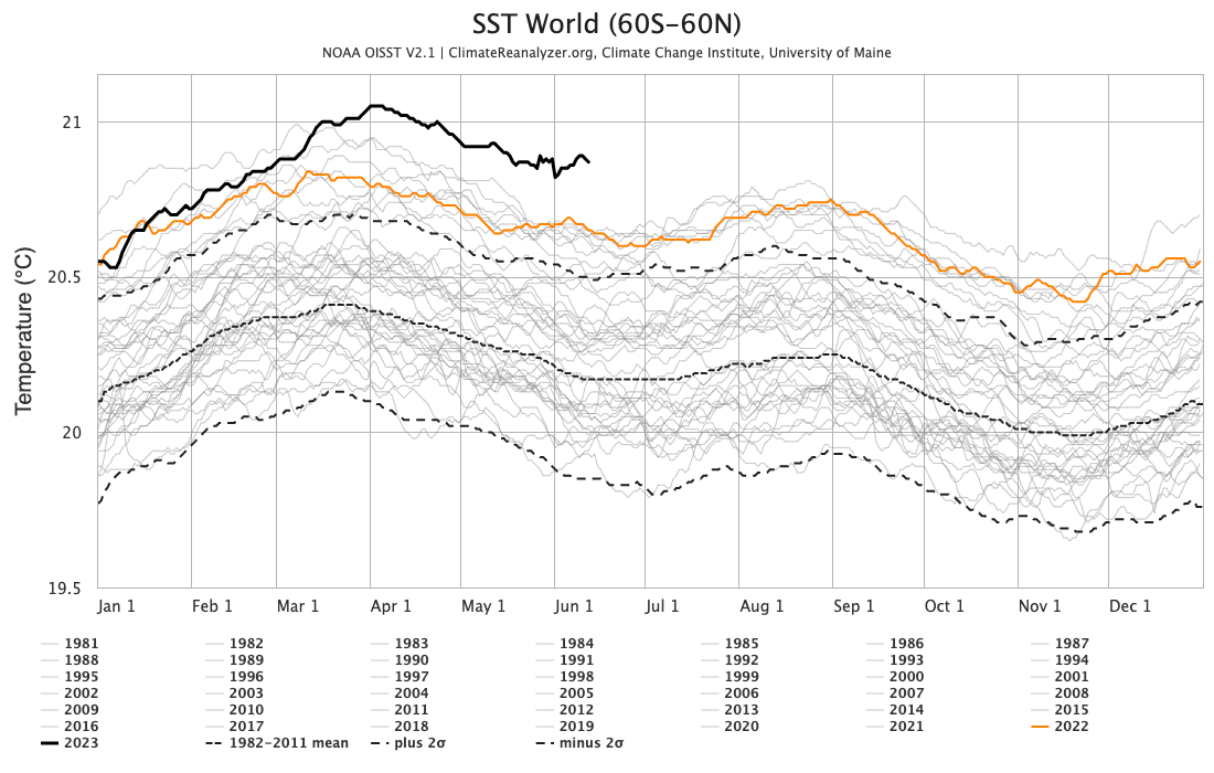
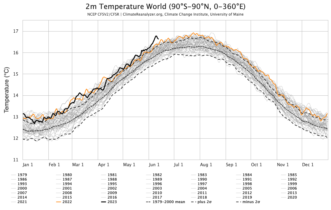
Images: Global sea surface (top) and surface air (bottom) temperature anomalies. Source: ClimateReanalyzer.org
While Australia’s recent run of abnormally warm weather has contributed to these record-breaking global temperature anomalies, the maps below show that even more abnormal warmth is occurring elsewhere.
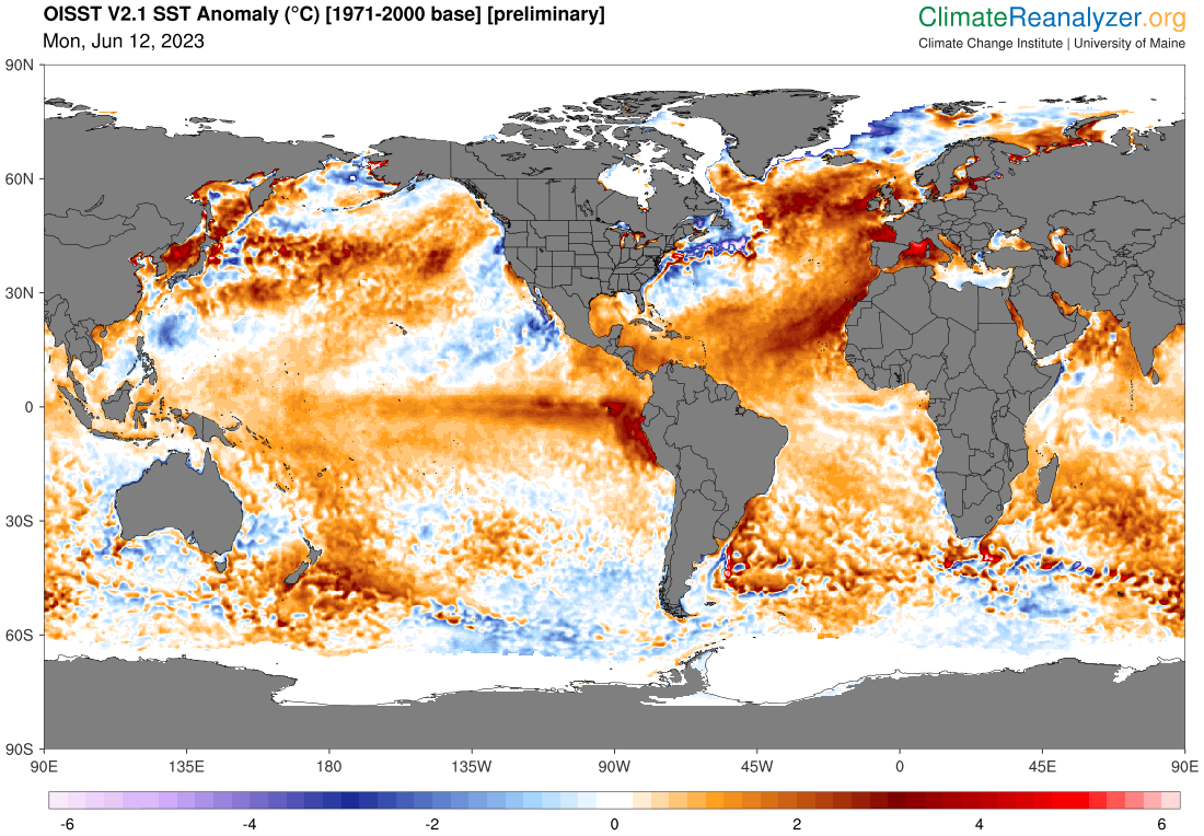
Image: Global sea surface temperature anomaly on June 12, 2023, using 1971-2000 as the baseline. Source: ClimateReanalyzer.org
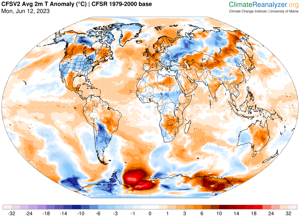
Image: Global surface air temperature anomaly on June 12, 2023, using 1979-2000 as the baseline. Source: ClimateReanalyzer.org
A developing El Niño pattern has caused unusually warm water to build up in the tropical Pacific Ocean in recent weeks. Another large blob of exceptionally warm water for this time of year has developed in the North Atlantic Ocean.
Air temperatures near the fringes of Antarctica have been more than 20ºC above average at times this month. This polar warmth is contributing to the lowest Antarctic sea ice extent in satellite records (since 1978).
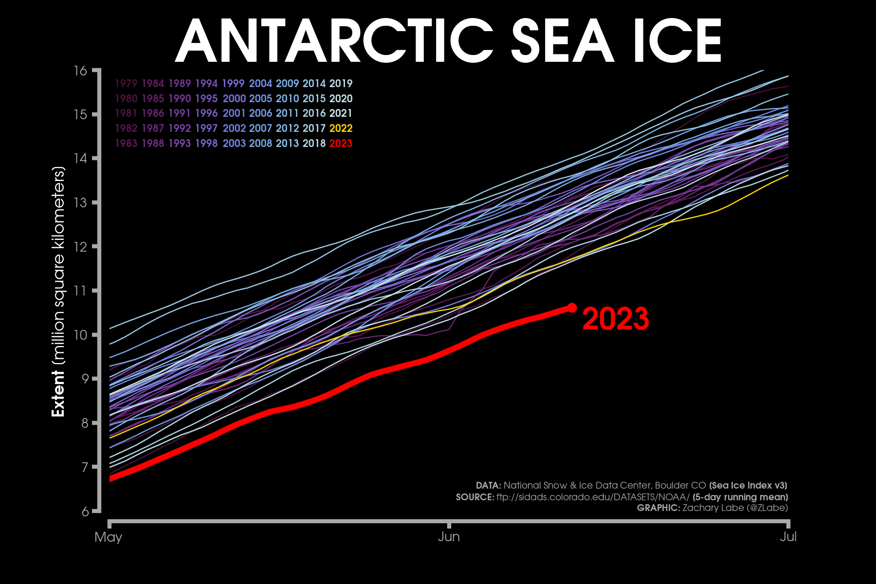
Image: Yearly Antarctic sea ice extent between 1979 and 2023, showing that 2023 is currently running below any other year in this period. Source: zacklabe.com
With the Pacific Ocean’s El Niño pattern expected to strengthen further in the coming weeks and months, more record-breaking warmth may be on the cards for our planet in the second half of 2023.
DTN APAC has a vast array of services available to meet the needs of any weather-exposed industry. From our Mining Blast Dispersion forecasts, Hub Height Wind forecasts, and Lightning tracking and alerting we have all your needs covered. To find out more, explore our website or email us at apac.sales@dtn.com.


