Prosper in a dynamic world
Search

Australia’s wettest April in 17 years, coolest in eight

Surges of tropical cloud and rainfall produced a relatively cool and wet April for large parts of Australia, although a few places in Queensland registered their warmest April on record.

Australia’s area-averaged rainfall during April was 41.4 mm, which is 10.9 mm above the 1961-1990 average and the country’s wettest April since 2006.

The map below shows that most of the anomalously high rainfall in last month occurred over WA, the NT and SA. This broad area of unseasonable rain was caused by injections of tropical moisture associated with Tropical Cyclones Herman and Ilsa.

Australia's wettest April in 17 years. coolest in eight

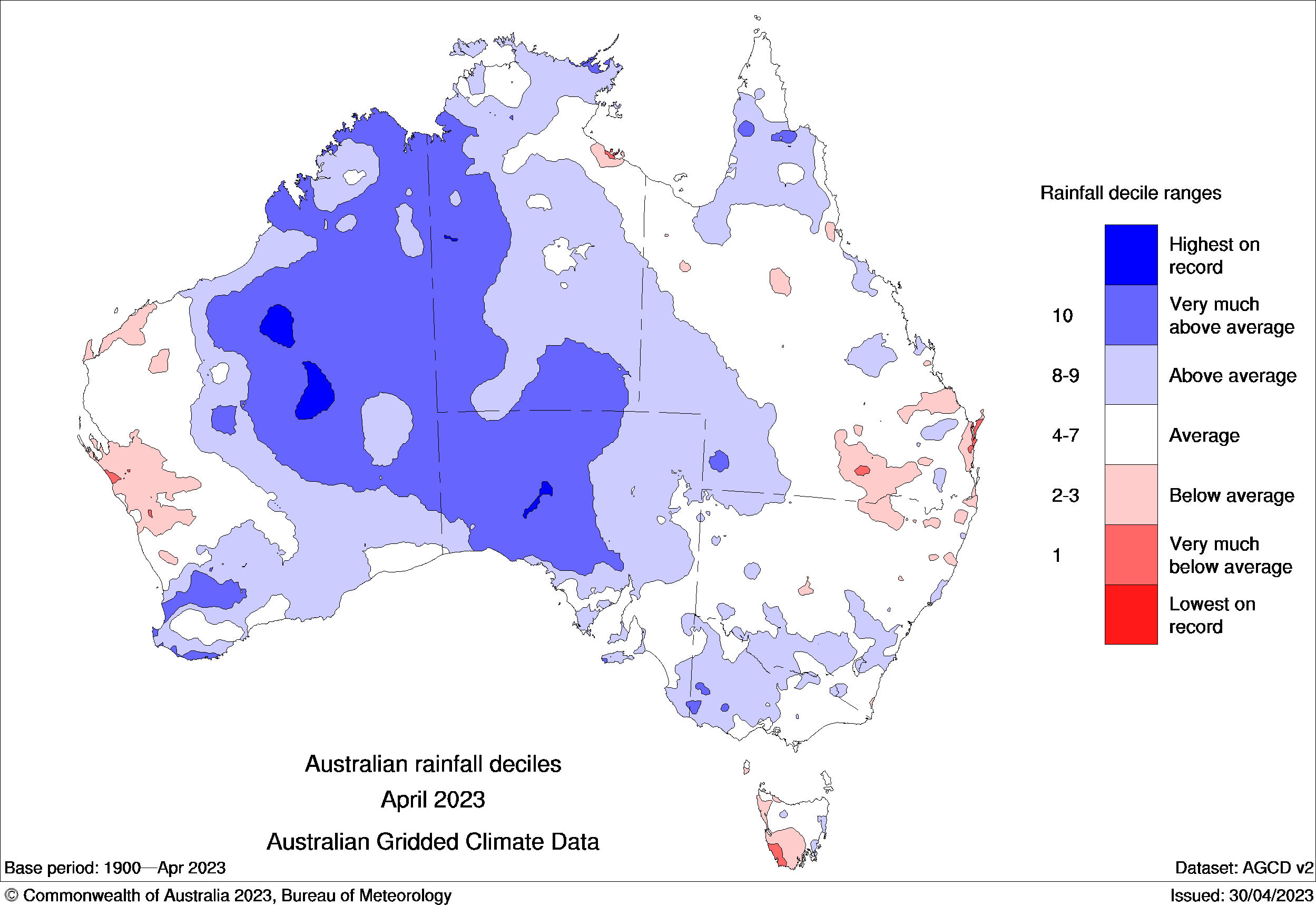
Image: Rainfall deciles during April 2023. Source: Bureau of Meteorology

Abundant cloud cover also helped suppress daytime temperatures over large areas of Australia last month. The country as a whole registered a mean maximum temperature of 28.65ºC, which is 0.05ºC below the 1961-1990 average and Australia’s coolest April maximum temperature since 2015.

Australia's wettest April in 17 years. coolest in eight

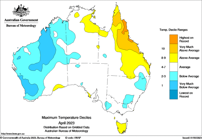
Image: Maximum temperature deciles during April 2023. Source: Bureau of Meteorology

But while April was relatively cool for Australia as a whole, there were some pockets of exceptional mid-autumn warmth.

Queensland’s mean maximum temperature was 1.1ºC above the long-term average and some areas in the state’s eastern tropical had their warmest April on record based on maximums.

DTN APAC can provide tailored climate briefings to your business to alert you of the most likely weather conditions and hazards to look out for during the upcoming season. Now is a good time to get a good look at the forecast for winter and beyond. To find out more or to book a presentation, please email apac.sales@dtn.com.

Latest news

Satisfy your weather obsession with these news headlines from around the nation, and the world.

Negative Indian Ocean Dipole officially underway – here’s what it means for Australian businesses and industries

A negative Indian Ocean Dipole (IOD) event is now underway, increasing the likelihood of above average rain over large parts of Australia in the coming months. What is the Indian Ocean Dipole (IOD)? The IOD is an index used to monitor sea surface temperatures across the tropical Indian Ocean. It’s an important index for the […]

La Niña more likely this year after BoM switches to new index – what does this mean for Australian businesses?

The likelihood of La Niña occurring in 2025 has increased due to a change in the way the Bureau of Meteorology calculates sea surface temperature anomalies in the tropical Pacific Ocean. What is La Niña? La Niña refers to a distinct pattern of sea surface temperatures across the tropical Pacific Ocean. When La Niña is […]

Southern Hemisphere’s polar vortex is weakening – here’s what this means for Australian weather

Stratospheric warming high above Antarctica could cause the Southern Hemisphere’s polar vortex to weaken at an unusually fast pace over the coming weeks. This weakened polar vortex has the potential to affect weather patterns across Australia and other parts of the Southern Hemisphere. What is the polar vortex? The polar vortex is a large circulating […]

Severe thunderstorms, tornadoes and flooding rainfall lash out over NSW businesses and industries

Severe thunderstorms, tornadoes and flooding rainfall have disrupted transport, rail, aviation and many other industries across NSW as a low pressure system tracked over the state. Severe thunderstorms and tornadoes in western NSW A tornado was observed near the town of Young on the South West Slopes of New South Wales around 3:30pm on Wednesday […]