Prosper in a dynamic world
Search

Records tumble in NSW and the ACT

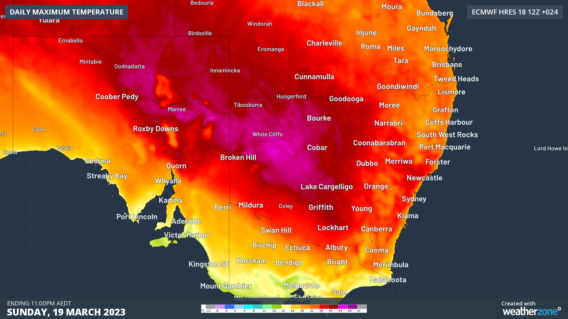
March records have tumbled in NSW and the ACT as the state sees an unusually late and widespread burst of extreme heat.

Both Forbes (40.7°C) and Wagga Wagga (39.9°C) have had their hottest March day in 83 years, with Bathurst (36.6°C) having their hottest March day in 81 years. Orange (34.5°C) had their hottest March day in 58 years. 

Some places even managed to bust long-standing records for their hottest March in history:

  • Katoomba (34.8ºC) with records available back to 1957
  • Mount Boyce (34.2°C) with a 33-year history 
  • Mudgee (38.3ºC) with 62 years of records
  • Moss Vale (37.0°C) with combined records at Moss Vale and Bowral dating back to 1962
  • Goulburn (37.6°C) with records back to 1962

The nation’s capital Canberra reached 37.4°C at 3:45pm, its hottest March day in 25 years. This is only 0.1 degrees off matching the long-term record of 37.5°C set in 1998 with records stretching back to 1939.

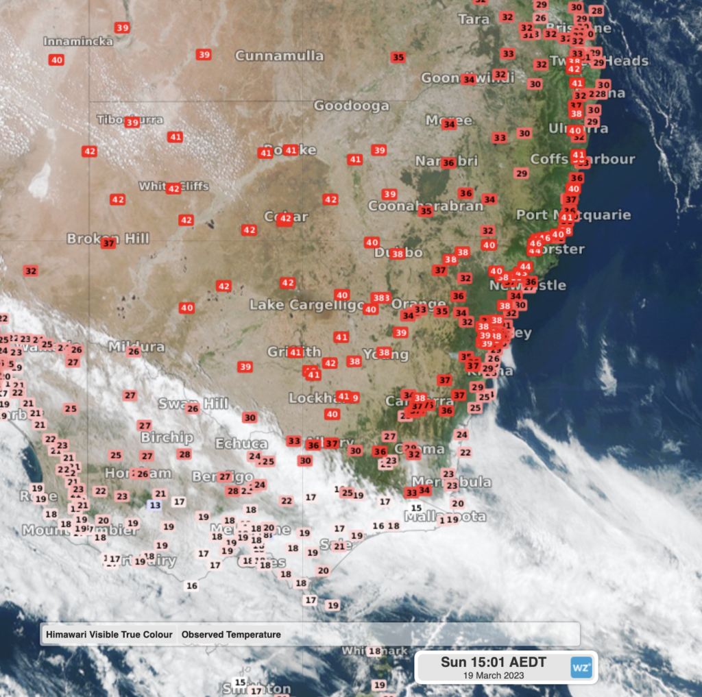
Image: Satellite image and observed temperatures over NSW at 3pm AEDT

This heat has been brought from the country’s interior and northern WA by a pair of slow-moving troughs over the last few days. The cold front that crossed SA, Victoria and Tasmania on Saturday now is pushing up over southern parts of NSW, bringing some welcome relief.

To find out about Weatherzones temperature and heatwave forecasts, visit our website or email us at apac.sales@dtn.com.

Latest news

Satisfy your weather obsession with these news headlines from around the nation, and the world.

How does DTN help businesses monitor bushfire induced pyrocumulonimbus thunderstorms that ignite more fires?

Intense heat from bushfires during elevated fire danger days can trigger fire-induced pyrocumulonimbus thunderstorms that ignite additional fires. In early January 2026, an extreme heatwave sweeping over southeastern Australia brought catastrophic fire danger to Victoria. Intensely hot bush and grass fires spread erratically and quickly in hot, dry and gusty winds, with pyrocumulonimbus generating lightning, […]

Active seas to the north and east of Australia disrupting port and maritime operations

Seas to the north and east of Australia are experiencing periods of increased activity this week, leading to disruptions to port, maritime and offshore operations. Intense and hazardous Tasman Sea Ocean conditions across NSW’s South Coast rapidly deteriorated last Friday as a deep feed of easterly winds whipped up large and dangerous seas. The Batemans […]

Transport, emergency and energy industries flooded across Greater Sydney with weekend deluges

Transport, emergency, energy and port industries in eastern NSW and Sydney were impacted by significant flash flooding with intense and heavy rainfall this weekend. Rainfall rates between 80 and 140mm in one to three hours were registered across parts of Sydney’s Northern Beaches and Central Coast on Saturday afternoon and evening. In some areas, these […]

DTN Dangerous Thunderstorm Alerts in action with severe thunderstorms disrupting Perth industries

Severe thunderstorms impacted southwest WA and the Perth region on Sunday, December 14, 2025, triggering Dangerous Thunderstorm Alerts (DTA) by DTN for industries and businesses in the region. DTN operates Dangerous Thunderstorm Alerts (DTA) which alert businesses and industries to thunderstorms based on intensity and movement. These alerts provide advanced notice of thunderstorms moving into […]