Norfolk Island just endured a direct hit from a category 2 tropical cyclone but barely had winds reach the strength of a category 1 system. So how did they escape the worst and how lucky was it?
What weather did they receive?
Norfolk Island recorded a maximum wind gust of 102km/h, typical of a category 1 tropical cyclone, and its strongest gust in at least 14 years. Sustained winds did not actually reach gale-force but were near-gale (sustained 50-60km/h) for about 24 straight hours from 6am on Saturday to 6am on Sunday. Rainfall added up to 102mm over the 2 days the storm crossed. While this rainfall is somewhat heavy, just 3 months ago they received 105mm in a 24-hour period on 3rd December. Oceans were about as rough as predicted, peaking at a significant wave height of 6-8 metres.
Did Norfolk Island receive a direct hit?
Yes, or as close as you could have for a small island. Winds died down to a measly 7km/h averaged over a 10-minute period at 10pm on Saturday night. This coincided with the lowest pressure reading of 958hPa, both suggesting the eye passed directly over the island. This is a globally accepted sign that a location was directly hit by a tropical cyclone. You can also see the characteristic 180° wind shift from NNE before the eye to SSW afterwards below.
Passage of Tropical #CycloneGabrielle over Norfolk Island. pic.twitter.com/vYvzi5I1FU
— Andrew Miskelly (@andrewmiskelly) February 11, 2023
While Gabrielle gave the residents of a rough ride, it was not as bad as the would-be record-breaking 140+km/h wind gusts that were forecast.
So why was it weaker than forecast?
Most of the break Norfolk Island received was due to Tropical Cyclone Gabrielle undergoing extratropical transition. This is a process that changes the low pressure system from using warm waters as its primary energy source to the difference in air temperatures on either side of the system. One of the tell-tale signs this is occurring is a tropical cyclone will start to lose its radial symmetry (looking like an annulus or ‘doughnut’ shape) and starting to stretch in certain directions. This stretching starts to develop both a cold front and warm front that is common closer to the poles.
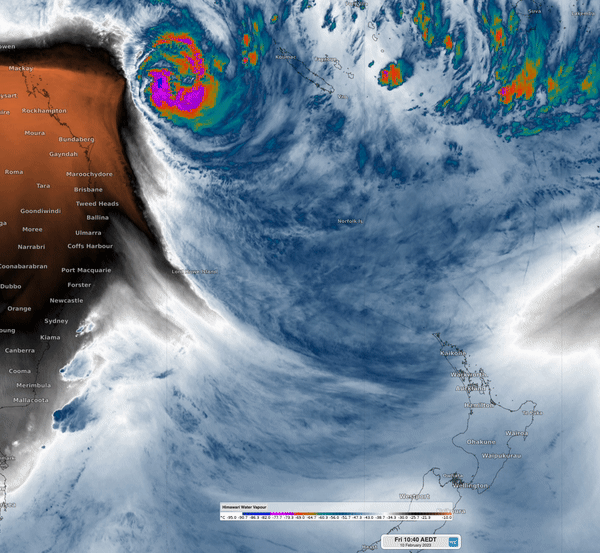
GIF: Water vapour around Tropical Cyclone Gabrielle showing cold, dry air in orange wrapping over the north, while the moisture in the warm front affects the southern side of the system.
Norfolk Island was fortunate to be located in the gap between the warm and cold fronts in the lead up to landfall, ensuring that winds were not as strong. Even as the typically strongest part of a tropical cyclone hit, the eyewall, it was so fragmented by this point that winds did not increase that significantly. In fact, the highest wind gust of 102km/h occurred at around 2pm, when the cold front hit the region, rather than with the eyewall.
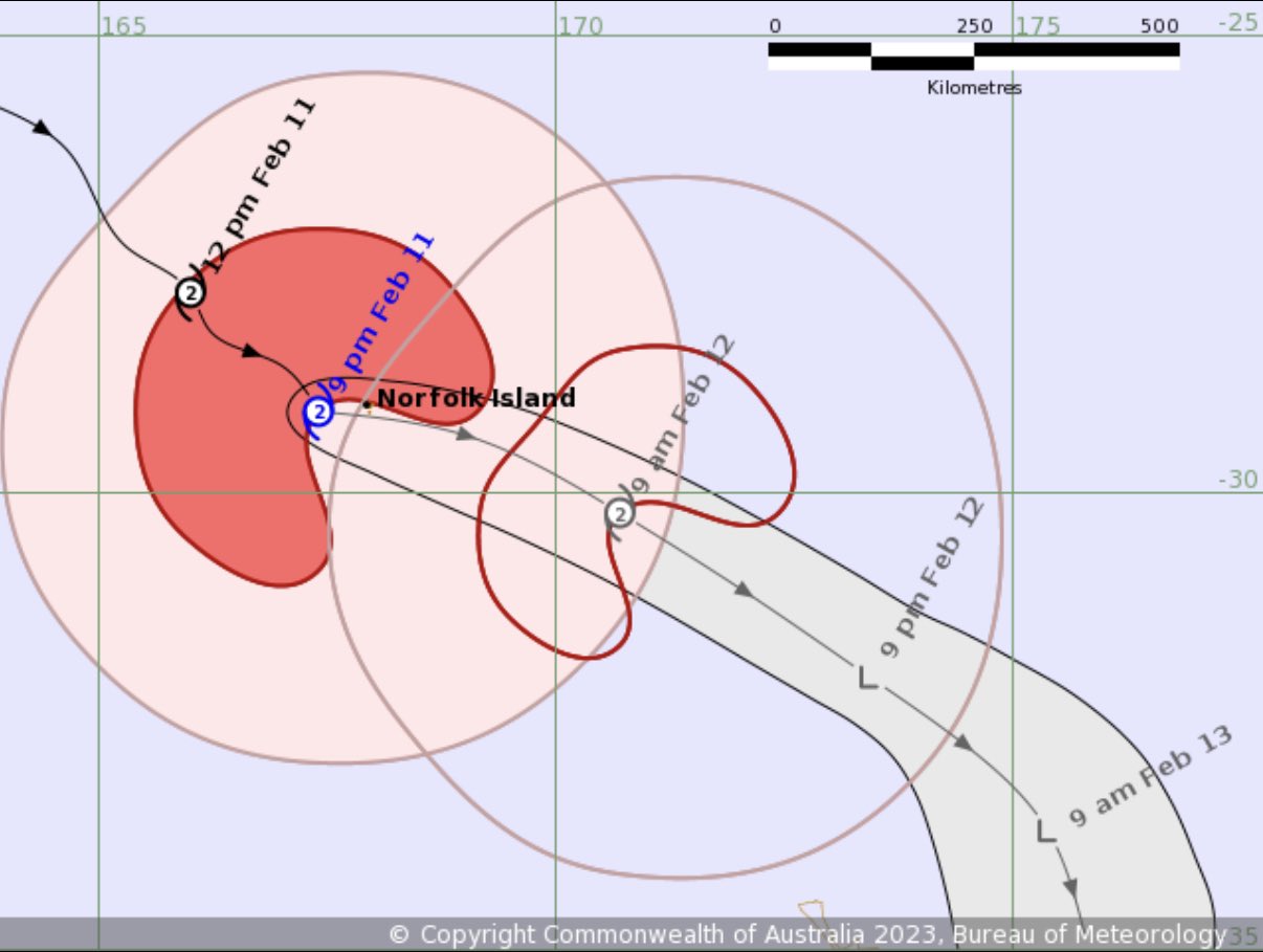
Image: Tropical cyclone track map issued by the Bureau of Meteorology at 9pm NFDT Saturday. The gap in the red shading shows the calmer winds in the slot between the cold and warm fronts.
If the system was just a little further north, Norfolk Island would have been more exposed to the powerful winds associated with the cold front many hours before the centre of the system approached.
The other fortunate aspect for the Island was where the areas of most convection were occurring. These can be seen on the southern, western and northern sides of Gabrielle at various stages during landfall. Due to some near-perfect timing, all of these areas of convection just missed the island even as they wrapped around it.
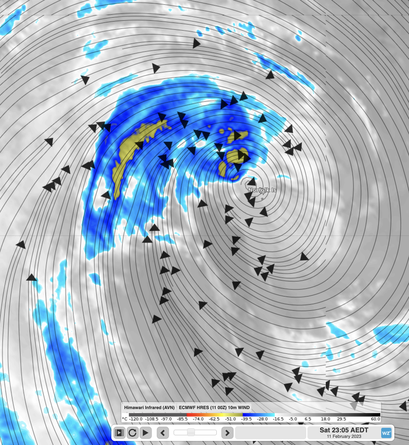
Image: A powerful area of convection (yellow shading) in the eyewall sweeping around just to the north of Norfolk Island at 11pm on Saturday
Thunderstorms in tropical cyclones can often see powerful wind gusts exceeding 130km/h, so avoiding these hazards was crucial. If the island was further south or west, it would have borne the brunt of Gabrielle, with intense rainfall and likely several powerful wind gusts (estimated exceeding 140km/h).
Overall, Norfolk Islanders can be quite relieved the system wasn’t as bad as forecast due to some fortuitous circumstances that were very hard, if not impossible to predict.
The now fully transitioned Ex-Tropical Cyclone Gabrielle is impacting the much larger North Island of New Zealand. Some areas will likely experience several hundreds of millimetres of rain and wind gusts exceeding 100km/h. You can see the warnings here.
How Weatherzone can help you prepare for Tropical Cyclones
DTN APAC has a suite of tropical cyclones services we provide to deliver our clients with as much forewarning of tropical cyclones as we can. We have 4 levels of forecasts timeframes:
- Tropical cyclone seasonal outlooks
- Weekly tropical update
- Daily 7-day tropical cyclone forecast
- Detailed tropical cyclone impacts (issued every 1-6 hours aligning with the BoM’s offical advisories)
Through these products you can have as much preparation as possible for tropical cyclones and their impacts. To find out more, please email us at apac.sales@dtn.com.


