
Tropical cyclones and heatwaves are both Australian summer staples, but did you know that a tropical cyclone can lead to a heatwave?
A heatwave in Australia, but particularly for the southeast, is often triggered by a special kind of high pressure system called a ‘blocking’ high. Blocking highs are high pressure systems that have been locked in place by the jetstream, meaning they stay virtually stationary for several days up to a fortnight. When there is a blocking high in the Tasman Sea, northerly winds (because in the southern hemisphere, winds blow anticlockwise around a high) are directed to South Australia, southern NSW, Victoria and Tasmania. If this happens over a lengthy period, hot desert air builds up, creating a heatwave.
Tropical cyclones can help trigger these heatwaves in two main ways. The first is shown in the diagram below.
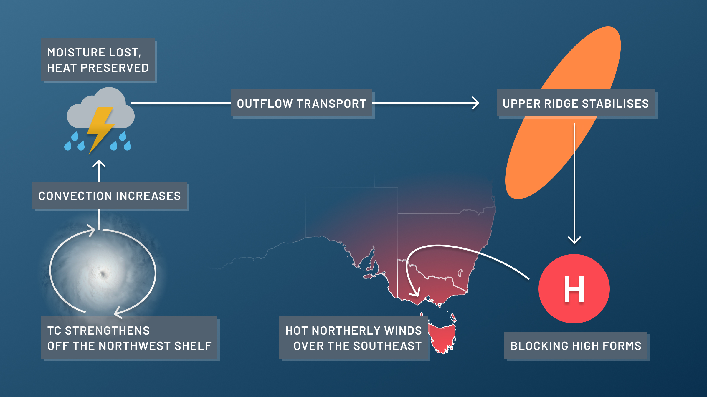
When a tropical cyclone builds strength of the northwest shelf of Australia, it causes more hot tropical air to rise high in the atmosphere. As it does, most of the moisture is lost through rain but the heat in it is preserved*. Because a tropical cyclone needs to disperse this rising air (what goes in must come out), the outflow of the tropical cyclone strengthens, sending hot air away from the system.
* Heat is not directly conserved because the pressure difference between the surface and aloft causes it to cool down. What is actually conserved is the air’s potential temperature. That means if we take the same parcel of air back to the altitude/pressure it came from, it would be the same temperature as before.
When this transported air meets the jetstream further south, it causes it to rotate anticlockwise and build an upper high pressure ridge. Any high pressure system beneath the new upper ridge now becomes a blocking high and locks in place. That allows the hot desert air to flow to the southeast.
The second way tropical cyclones cause heatwaves is that the air that accumulates in the upper ridge will slowly start to descend back down to the ground in a process called subsidence. While this can take days or even weeks, the blocking high can give the air enough time to make this journey towards the ground. As the air descends, it warms back up to its original temperature, providing extra heat and energy to the heatwave.
Both above processes were crucial in creating one of the worst heatwaves in Australian history: the January/February 2009 heatwave that occurred in the days leading up to the infamous Black Saturday Bushfires (7th February 2009). During this heatwave Melbourne reached 43°C for three consecutive days, and the all-time state temperature records were set in Victoria (48.8°C in Hopetoun) and Tasmania (42.2°C in Scamander). This heatwave was heavily influenced by Tropical Cyclone Dominic, a category 2 system that brought severe flash-flooding around Onslow and the Gascoyne River. The outflow from this cyclone, triggered a large blocking high to form in the Tasman Sea.
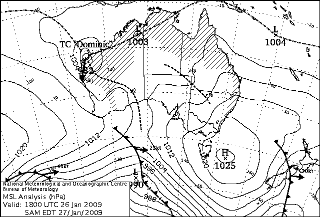
Image: MSLP chart from 27th January 2009, showing TC Dominic over the northwest shelf, and the blocking high developing just west of Tasmania. That high would stay in virtually the same position until 2nd February.
Tropical cyclones links to heatwaves in Australia perfectly embodies the line “A land of droughts and flooding rains” from Dorothea Mackellar’s famous poem “My Country”. So, when you see a tropical cyclone brewing off the northwest shelf and heat building in the south, remember that they are often linked.
DTN APAC provides forecasts temperatures up to 14 days ahead, so your business can have the up to 2 weeks warning of an impeding heatwave. To find out more, please visit our website or email us at apac.sales@dtn.com.




