
La Niña appears to be on its last legs and some long-range forecast models are hinting at the return of El Niño later this year.
The Pacific Ocean is currently in a La Niña pattern that has been in place, on and off, over the past three years. This prolonged period of La Niña events produced record-breaking rain and flooding over large areas of Australia.
However, the current La Niña has been weakening over the last few weeks and most forecast models suggest that it will soon come to an end.
After La Niña, what comes next?
It’s very unlikely that we will see a fourth consecutive La Niña event developing in 2023. We can say this with some confidence because four back-to-back La Niña events have never been recorded before and no forecast models are saying that another La Niña will occur this year.
That leaves either El Niño or neutral conditions (neither El Niño nor La Niña) in the Pacific Ocean in 2023.
The Pacific can’t flip from La Niña to El Niño without first passing through a neutral phase, so a neutral Pacific Ocean is what we are likely to see in the immediate aftermath of the current La Niña.
Indeed, there is good model consensus that the Pacific Ocean should return to a neutral phase by the end of the Southern Hemisphere’s summer (Northern Hemisphere’s winter).
Then, as we venture further into 2023, it becomes unclear whether the Pacific Ocean will stay in a neutral state or transitions into El Niño.
Numerous forecast models increase the likelihood of El Niño during the middle of this year. The graphs below show the most recent official ENSO outlooks from Australia’s Bureau of Meteorology, and the U.S. Climate Prediction Center (CPC) and Columbia University’s International Research Institute for Climate and Society (IRI).
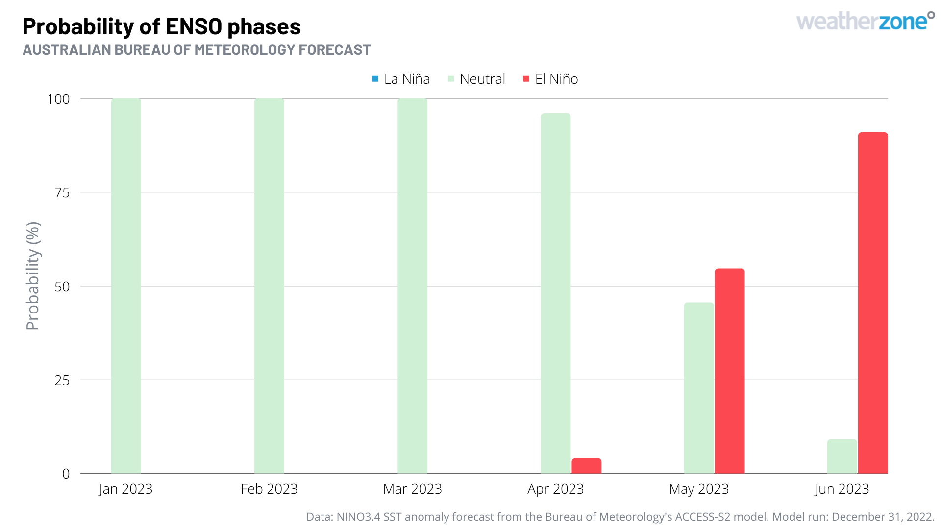
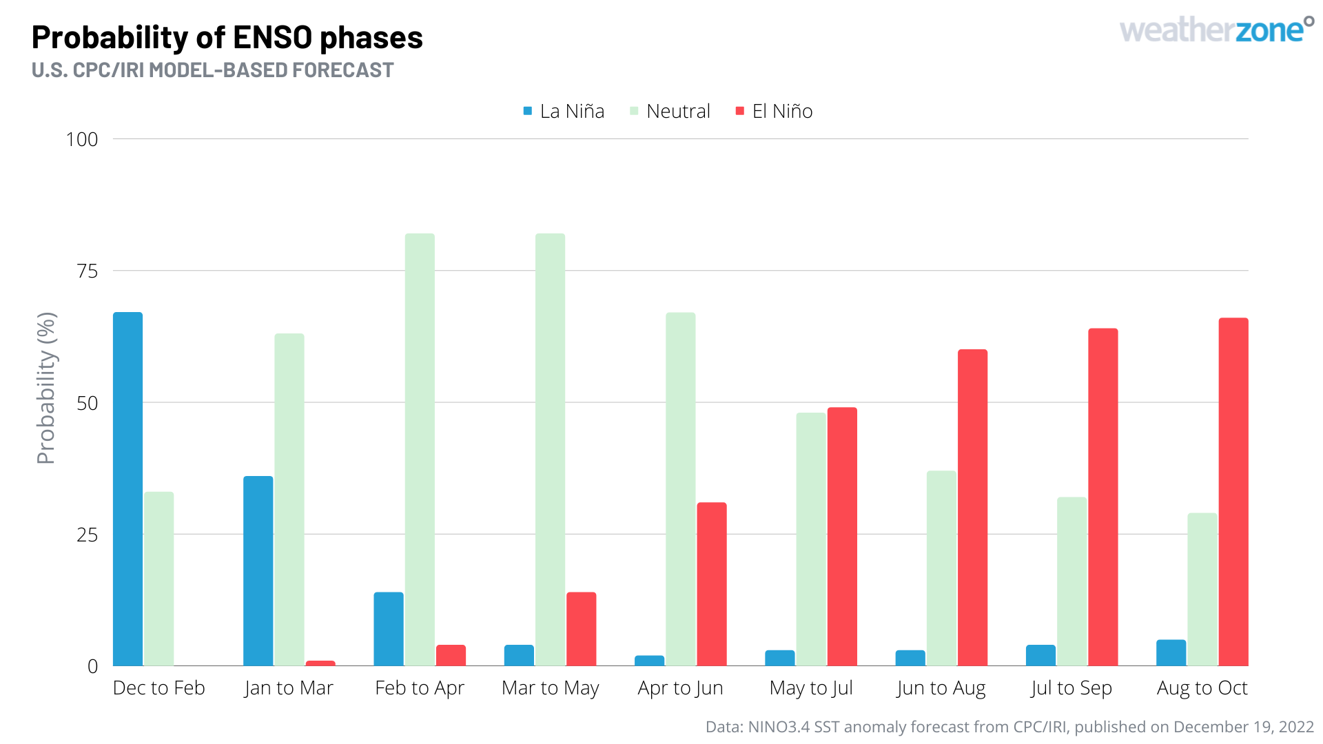
Images: Official El Niño-Southern Oscillation (ENSO) outlooks from the Australian Bureau of Meteorology, and the U.S. Climate Prediction Center (CPC) and Columbia University’s International Research Institute for Climate and Society (IRI). These outlooks are based on the most recent Niño-3.4 sea surface temperature anomaly forecasts from each organisation.
Both of the forecast graphs above show a clear transition towards El Niño in the middle of 2023, with El Niño becoming more likely than neutral conditions from around May or June.
Despite this clear signal in the outlooks, it is very important to point out that the accuracy of these models is lower at this time of year and should be treated with some caution.
According to Dr Andrew Watkins, Technical Lead of Extended Prediction at the Bureau of Meteorology, “the Bureau surveys several international climate models when making its ENSO predictions. ENSO outlooks for May 2023 and beyond show a range of possibilities depending upon the climate model used. We will need to wait till late summer and early autumn to have a clearer and more accurate view of what is coming next winter.”
It will be worth keeping a close an eye on the Pacific Ocean and its overlying atmosphere in the coming months to see how things evolve as we head further into 2023. To find out more about DTN APAC climate briefings, please email us at apac.sales@dtn.com.


